
 Portuguese
  Spanish
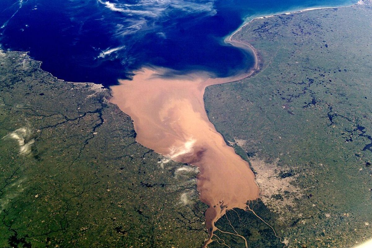
Discover The Río de la Plata, Unique Estuary of South America, With Brackish Zone, Giant Watershed, And Key Role In The Hydrological System.
At the southernmost tip of South America, the Río de la Plata seems to defy any simple definition. It receives the colossal waters of the Paraná and Uruguay rivers, forming a funnel spanning hundreds of kilometers and opening an impressive gap on the coast before meeting the Atlantic. It is not just an ordinary river, nor a closed sea, nor merely a bay. It is a hybrid that intrigues scientists and rewrites the way we view the continent’s great water systems.
Alongside the Amazon basin, the system formed by the Paraná, Uruguay, and the Río de la Plata itself is the second major water giant of South America, draining a huge portion of the continent’s interior. But about 280 kilometers before releasing its waters into the ocean, the banks cease to be “narrow river” and open into an immense funnel of murky waters, suspended sediments, and brackish zones. It is in this environment that geology, hydrology, and oceanography converge, turning the Río de la Plata into a scientific puzzle.
A Colossal Funnel Between Rivers and Ocean
As the Paraná and Uruguay rivers approach the Atlantic, the Río de la Plata ceases to behave like a traditional watercourse.
-
James Webb Telescope Uncovers Unexpected Clues on Mysterious Moon, Potentially Redefining Planetary Origins

-
$1.5 Billion Sleipnir Vessel Transforms Ocean into Floating Construction Site with 12 Hybrid Engines and Capacity to Lift 20,000 Tons

-
23 Years After Tragedy, Brazil’s Alcântara Space Center to Launch New Suborbital Rocket in 2026 with South Korean SEBIT Project Targeting Near-Space Tests
-
Entrepreneur Turns Neighbor’s Coffee Grounds Waste into Eco-Friendly Pellets, Earning Up to $40,000 Monthly in Brazil


About 280 kilometers before opening to the ocean, the banks begin to recede, and the channel widens into a funnel shape, creating a massive indentation on the South American coast.
This transition is not a classic delta, with multiple channels and islands, as seen in the Amazon. Instead, the Río de la Plata forms a kind of open horn, where the width increases much more rapidly than the distance to the sea.
The depth also follows a different pattern. What was once a very deep depression now presents a gentle gradient, with bottoms ranging from approximately 2 to about 20 meters in the transition zone with the Atlantic, resulting from millions of tons of accumulated sediments over time.
It is as if the Río de la Plata were a gigantic aquatic corridor that cushions the passage between the riverine and marine environments, spreading energy, sediments, and salinity over a vast area.
The Geological Origin of The Río de la Plata
The strange and monumental shape of the Río de la Plata is not a product of chance. It was born from an ancient wound in the Earth’s crust.
During the fragmentation of the supercontinent Gondwana, a vast geological fault formed in the region, opening a large depression that would serve as a mold for the future estuary.
This fault created a kind of “notch” in the continental margin, a natural fit for the ocean that reached depths of about 2 kilometers.
Over the ages, tectonics continued to shape the South American relief, and much of the surface runoff of the continent was redirected to this depression.
The great rivers then began to dump millions of tons of sediments there, which accumulated and slowly filled the bottom.
Today, the balance between sediment input from the rivers and the action of the Atlantic tides results in a Río de la Plata with a relatively shallow bottom, gentle gradient, and a very particular transition between the interior of the continent and the open ocean.
Freshwater, Brackish, And Marine Zones In The Río de la Plata
Throughout its 280 kilometers of estuarine extension, the Río de la Plata is not uniform. It is compartmentalized into zones with distinct physical and chemical characteristics, creating completely different habitats within the same body of water.
Near the mouth of the rivers that feed it, the fluvial influence is dominant. There, the Río de la Plata presents low salinity, around 2 practical salinity units, functioning almost like a freshwater environment.
It is an area where water still behaves more like a river, although it is already within the large funnel that leads it to the sea.
As one moves toward the ocean, a wide area of brackish water emerges, known as the mixing zone.
In this section, salinity gradually increases and organizes into a strong vertical gradient, with saltier water near the bottom and fresher water at the surface.
Suspended sediments remain intense, giving the water an orange or brownish color, one of the most prominent visual marks of the Río de la Plata.
After surpassing the region where Montevideo, the capital of Uruguay, is located, the Río de la Plata reaches its greatest width and greatest depth within the funnel.
In this area, the push of the Atlantic tides becomes much stronger, and salinity increases to levels that can be more than ten times those measured at Buenos Aires.
This is the stretch in which the system approaches a marine environment, although it still maintains the transitional identity typical of a large estuary.
The Scientific Enigma: River, Bay, Marginal Sea, or Estuary
It is no wonder that the Río de la Plata is considered a puzzle within hydrology. It does not fit perfectly into classical definitions.
By name, it would be a river, since “river” in Spanish and Portuguese means exactly that. But when we look at the geometry and function, calling the Río de la Plata simply a river is inadequate.
It somewhat resembles a bay, as it is a wide cut in the coastline where the continent curves inward, making space for marine waters.
It also bears traits of a marginal sea, as it is a semi-closed body linked to the ocean, influenced by tides and with a wide opening to the Atlantic.
At the same time, its functional essence is that of an estuary, the mouth zone of a large river system affected by tides, where freshwater and saltwater meet and form brackish water.
The strong presence of the mixing zone and the vertical salinity gradient makes the estuary the category that best captures the identity of the Río de la Plata, even though it is much larger and more complex than the majority of classic estuaries described in books.
Therefore, the scientific community continues to debate. Each definition brings elements that apply in part, but none seem to fully embrace what the Río de la Plata is in practice.
A Natural Laboratory To Understand Large Hybrid Systems
Besides being an important point in South American geography, the Río de la Plata serves as a natural laboratory.
In it, one can observe how giant rivers deliver sediments to the sea, how salinity organizes in large estuaries, and how the relief inherited from ancient tectonic plates continues to influence the behavior of current waters.
The funnel shape, the history of geological faults, the filling by sediments, and the complex brackish zone make the Río de la Plata a model for studying transitions between riverine and marine environments at large scale.
It helps to understand everything from the formation of specific habitats to the transport of nutrients, pollutants, and organic matter between the continent’s interior and the ocean.
In the end, the Río de la Plata shows that simple labels do not always capture reality. More than a river, bay, marginal sea, or estuary, it is a hybrid system that holds the memory of Gondwana in its shape and waters, the pulse of the great rivers, and the breath of the Atlantic tides.
And for you, who reads about this South American water giant, is the Río de la Plata more river, sea, or estuary?


