Portuguese
  Spanish
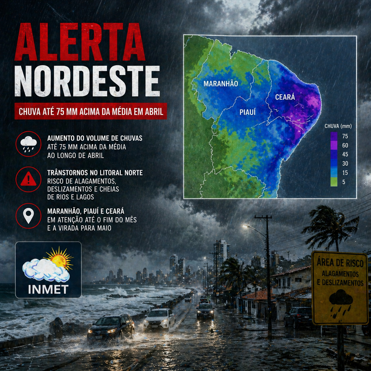
INMET indicates above-average rain in the Northeast in April, with risk of storms, high accumulations, and impacts on coastal cities.
On April 1, 2026, the National Institute of Meteorology (Inmet) confirmed a scenario of concern for a significant part of the Northeast: the official climate forecast for April indicates rain up to 50 mm above the historical average in practically all states of the region, with the exception of Bahia, where volumes tend to be close to climatology. The most significant highlight appears in the north of Maranhão, Piauí, and Ceará, where the positive anomaly can reach up to 75 mm above the historical average for April.
This positive deviation indicates a potentially wetter than normal month in broad areas of the Northeast, especially in the northern strip of the region, but Inmet’s official prognosis speaks of an above-average rain anomaly and not, in itself, a continuous sequence of severe events throughout the month.
Northern coast concentrates higher risk with high accumulations and storms
The INMET weekly forecast reinforces that the north-central Northeast, especially Maranhão, Piauí, and Ceará, should concentrate the largest volumes. In some areas, accumulations can:
-
8-Year-Old Finds 900-Year-Old Viking Bronze Buckle on Swedish Beach While Fossil Hunting
-
China Tests Giant 582-Ton Magnets to Contain Plasma Hotter Than the Sun’s Core, Aiming to Cut Superconductor Costs and Generate First Electricity from “Artificial Sun” by 2030
-
Lenovo Unveils Legion Y700 Tablet with RGB Backlighting, 5G, and SIM Card Support
-
Lenovo Unveils Legion Y700 Tablet with RGB Backlighting, 5G, and SIM Card Support
- Exceed 100 mm in a few days
- Reach 150 mm in isolated spots
- Repeat over consecutive weeks

This behavior is associated with the persistence of atmospheric systems that keep the atmosphere loaded with moisture. When high volumes repeat in sequence, the soil saturates and the risk of disruptions increases significantly.
Intertropical Convergence Zone keeps the Northeast under constant instability
The main driver of this scenario is the Intertropical Convergence Zone, known as ITCZ. This system is responsible for:
- Formation of heavy clouds
- Frequent and voluminous rains
- Persistence of atmospheric instability

April is precisely the period of greatest ITCZ activity in the extreme north of Brazil, which explains the increase in the frequency and intensity of rains.
The continuous presence of this system prevents long periods of stability, keeping the region under recurrent risk of intense precipitation.
Recent events already show extreme accumulations in a short period
The pattern predicted for April is not just theoretical. Recent data from the National Center for Monitoring and Natural Disaster Alerts indicate that, by the end of March 2026, several areas in the North and Northeast had already recorded high volumes in a short time.
Some examples include:
- More than 130 mm in Salvador (BA)
- More than 120 mm in Maceió (AL)
- High accumulations also in cities in Maranhão
These episodes reinforce that the atmosphere is already in a state favorable for intense rainfall. When extreme events begin to occur even before the peak of the rainy season, the risk for the rest of the month increases.

Difference between coast and interior creates contrast of impacts within the region
Despite the general scenario of above-average rainfall, the behavior is not uniform throughout the Northeast. The coast, especially the north and part of the east coast, tends to record:
- More frequent rainfall
- Higher accumulated volumes
- Higher risk of storms
The interior, on the other hand, may present:
- More irregular rainfall
- Periods of dry weather
- Lower accumulated volume
This contrast creates different types of impact within the region itself, with some areas facing excess water while others deal with water irregularity.
Coastal cities enter alert zone for flooding and disruptions
With high volumes and concentrated events, urban areas begin to face direct risks. Among the main impacts are:
- Flooding on urban roads
- Overload of drainage systems
- Transportation disruption
- Water accumulation in vulnerable neighborhoods
Cities on the north and east coasts are particularly sensitive to this type of scenario, due to their proximity to the ocean and high urban density.

When intense rainfall coincides with high tide or limited drainage, impacts can intensify rapidly.
Agriculture and infrastructure can also be affected by excessive rainfall
Excessive precipitation does not only impact urban areas. In rural areas, high volumes can cause:
- Soil waterlogging
- Difficulty in agricultural management
- Loss of productivity
- Logistical delays
Furthermore, rural roads and local infrastructure can suffer damage due to soil saturation. Excessive rain can be as problematic as drought, depending on the intensity and duration of the events.
Pattern reinforces trend of greater climate variability in the Northeast
The behavior observed in April 2026 is aligned with a broader scenario of climate variability. The alternation between periods of intense rainfall and drier phases has become more frequent, influenced by factors such as:
- Ocean temperatures
- Changes in atmospheric circulation
- More intense seasonal variations
This irregularity makes climate planning more challenging for cities and productive sectors.
Constant monitoring will be decisive to reduce risks in the coming weeks
Given this scenario, monitoring weather forecasts gains strategic importance. Alerts issued by agencies such as INMET allow anticipating events and reducing impacts.
Frequent updates on atmospheric conditions are essential, especially during periods of persistent instability. The capacity for response depends directly on the quality of real-time information available.
Given this scenario, is the Northeast prepared to deal with increasingly intense and frequent rains?
The advance of an above-average rainfall pattern across virtually the entire region places the Northeast in a moment of attention at the end of April.
With high volumes, concentrated events, and impacts already observed in recent episodes, the scenario points to a period of increased risk.
The central question is whether cities, drainage systems, infrastructure, and regional planning are prepared to face a climatic pattern that tends to be more intense, irregular, and unpredictable in the coming years.