
 Portuguese
  Spanish
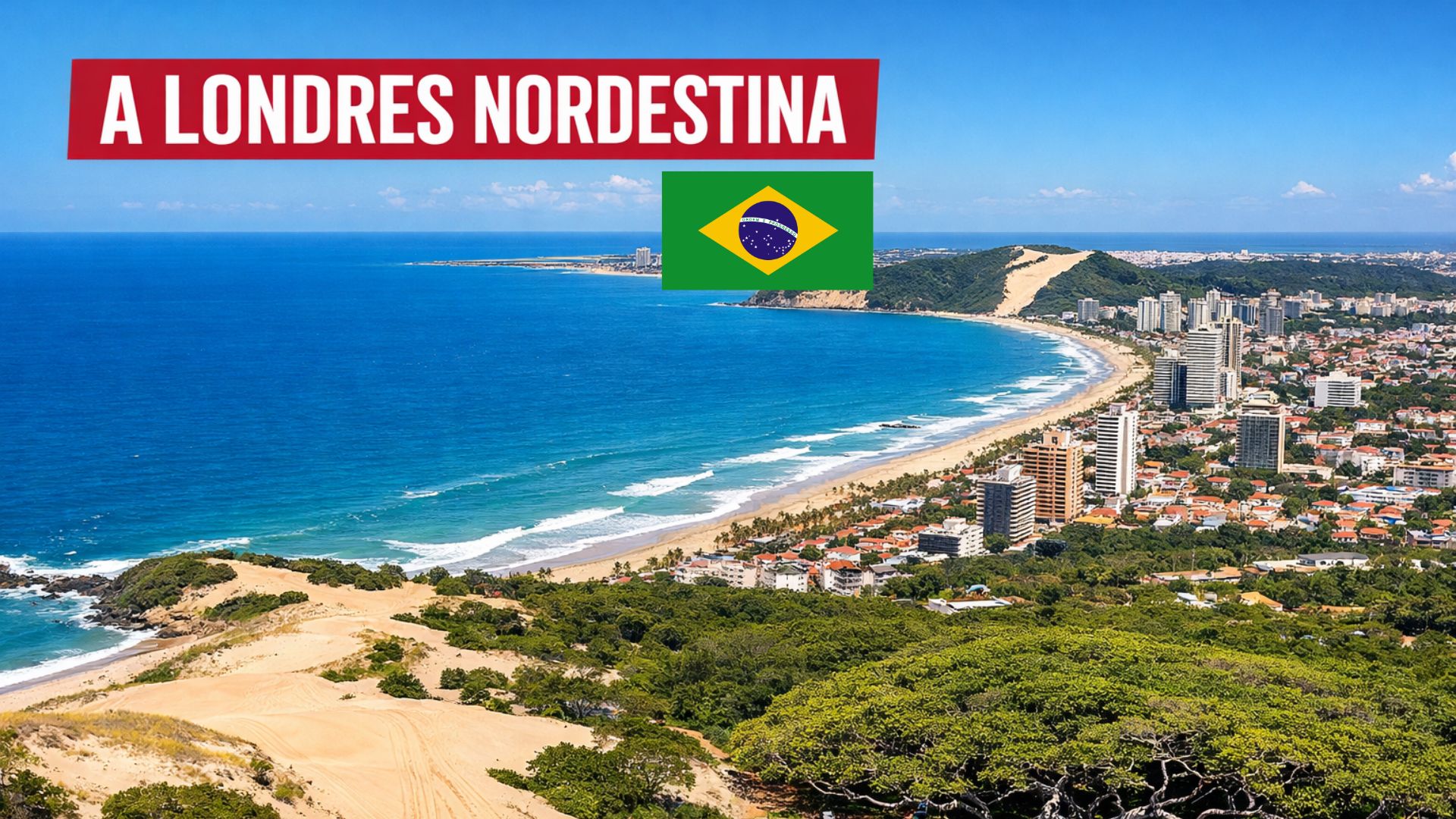
Northeastern Capital That Combines Almost Permanent Sun, Preserved Dunes, High Social Indicators, and an Economy That Goes Beyond Tourism, Natal Brings Together Natural Landscapes, Active Urban Life, and Cultural Symbols That Help Explain Its National and International Projection as a Destination and City to Live In.
Natal, the capital of Rio Grande do Norte, concentrates urban beaches, dunes, and preserved forest areas just minutes away from neighborhoods with services, commerce, and a hotel network.
The city earns the nickname “City of the Sun” as it is often described as having more than 300 sunny days a year and experiences relatively small temperature variations throughout the months, according to Climatempo’s climatology.
Data from IBGE also indicate a HDI of 0.763 (2010), an index that places the municipality in the high human development range and is often used as a reference in regional comparisons.
-
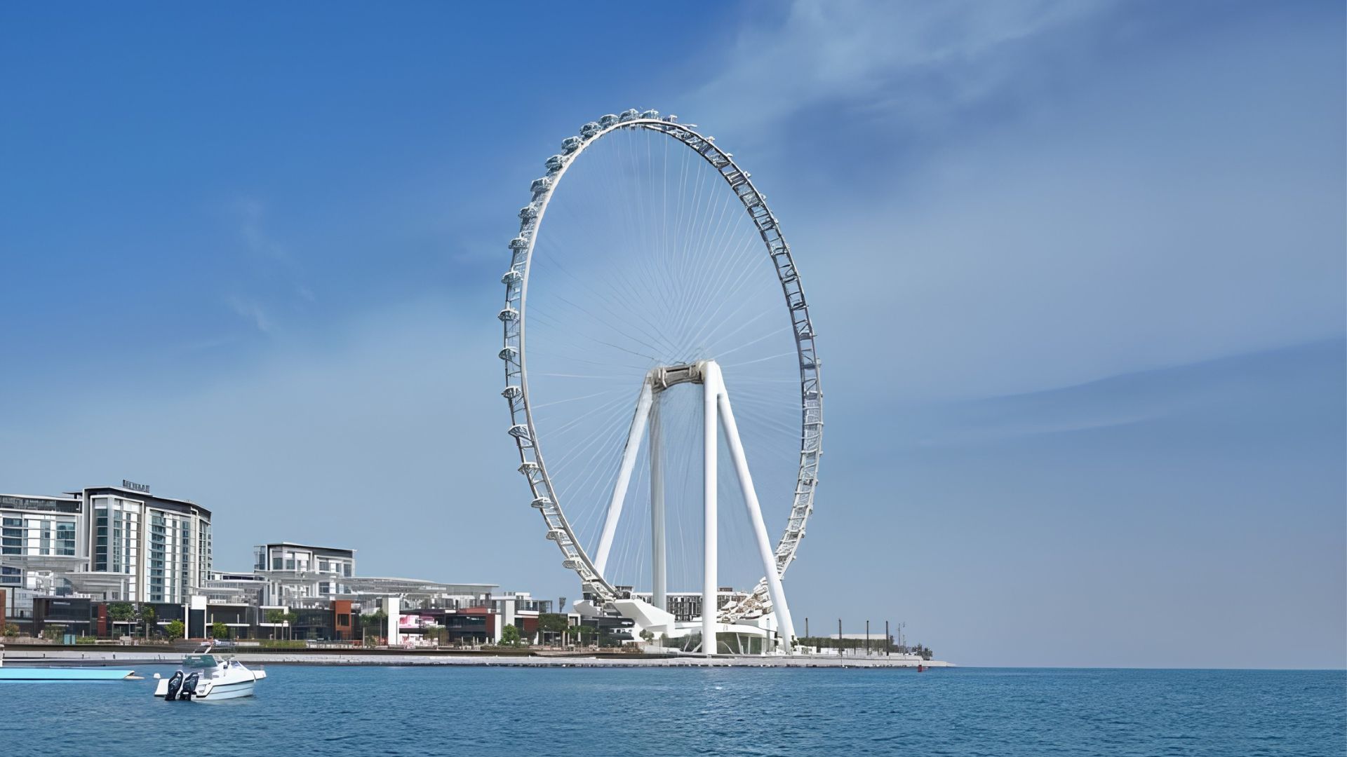
World’s Tallest Ferris Wheel Opens in Dubai, Offering Thrilling Heights Over the Persian Gulf

-
Northern Lights May Be Visible in 19 U.S. States Tonight as Solar Ejection Approaches Earth, Potentially Triggering Geomagnetic Storm

-
Energy-Efficient Upgrade: Brazilian Utility Offers Discounts to Replace Old Fridges and Bulbs with New Models in Paraná Homes
-
World’s Fastest Tractor, the JCB Fastrac Two, Hits Nearly 247.5 km/h with Over 1,000 Horsepower


At the same time, part of the international fame and local slogans surrounding Natal, such as the idea of having “one of the purest airs in the Americas,” circulate in publications and promotional materials without clear public documentation regarding methodology, period, and comparative criteria.
This contrast between tourist image, official data, and narratives consolidated over time helps explain why the capital of Rio Grande do Norte is often described by different labels.
Among them is the term “Northeastern London,” a recurring expression in the local imagination, but without a standardized historical origin.
Urban Daily Life Among Dunes, Central Neighborhoods, and Green Areas

In daily life, the city organizes itself between dense areas and circulation axes that approach the sea and large portions of native vegetation.
One of the central points of this relationship is the Dunas State Park of Natal, known as Parque das Dunas, created in 1977 and managed by the state environmental agency.
The area is often described as one of the largest urban parks in the country, playing a significant role in regulating the microclimate and conserving remnants of Atlantic forest within the urban mesh.
Meanwhile, regions like Tirol, Petrópolis, and Ponta Negra concentrate services, commerce, and a substantial part of the circulation of residents and visitors.
The result is a routine where commutes for work, study, and leisure coexist with the landscape of dunes, restinga, and constant wind, a characteristic associated with the trade winds of the potiguar coast.
The dynamics of a capital brings typical challenges of urban centers, including security issues, but also reinforces the city’s role as a regional hub.
This role is reflected in the presence of universities, hospitals, commerce, and specialized services that cater not only to Natal’s residents but also to individuals from the metropolitan area and the interior of the state.
Social Indicators and Economy Beyond Tourism
IBGE records a HDI of 0.763 (2010) for Natal, a number published in its municipal panels and aligned with the Human Development Atlas.
The index combines income, education, and longevity and frequently appears as a benchmark for comparison within Rio Grande do Norte and the Northeast.
In the local economy, tourism holds a prominent position, but does not exhaust the municipality’s productive activity.

The service structure, health network, and urban commerce sustain a significant portion of daily activity, while the metropolitan region hosts activities frequently mentioned in economic analyses, such as segments of the textile chain and shrimp farming.
This combination helps explain why Natal has characteristics of a tourist city and, at the same time, a capital with its own dynamics outside the high season.
In demographic terms, IBGE points to a population of 751,300 people in the 2022 Census and an estimate of over 780,000 inhabitants in 2025, reinforcing the urban size of the municipality.
Buggy on the Dunes and Experiences That Shape Local Tourism
Among the tours most associated with the image of Natal are the routes that head north to the coast, with an emphasis on the moving dunes of Genipabu, in Extremoz, a neighboring municipality.
In this itinerary, the question “With or Without Emotion?” has become a cultural signature of the ride and defines whether the journey will have more intense maneuvers or a more moderate drive.
The circuits vary according to tide, wind, and daily conditions, combining crossings through dunes, beaches, and lagoons.
Around this route, freshwater lagoons serve as a pause along the way, with tourist activities that have become trademarks of the region.
At sea, part of the flow is directed towards the natural pools formed by reefs, such as the Parrachos de Maracajaú, often described as being about 60 km from Natal in tourist itineraries.
Within the city itself, the Ponta Negra Beach remains an urban postcard, with the Morro do Careca prominently featured on the horizon.
The dune, cited in various references as having about 107 meters, has had restricted access for years, a measure adopted to reduce environmental impacts and preserve the vegetation and stability of the terrain.
Fort of the Kings Magos and the Historical Origins of the Capital

The history of Natal appears directly to many visitors at the Fort of the Kings Magos, a building linked to the beginning of Portuguese occupation in the region and often presented as a founding landmark of the city.
Widely cited historical records indicate December 25, 1599 as the date associated with the founding of the municipality.
The construction of the fort dates back to the end of the 16th century and occupies a strategic position at the mouth of the Potengi River.
The site integrates routes that address colonial disputes on the northeastern coast and helps contextualize the urban formation of the capital.
In addition to this period, Natal also preserves memories from the 20th century, such as the strategic role of the state during World War II, a theme present in museums, archives, and historical tours around the city.
Largest Cashew Tree in the World and the Landscape of Pirangi
Along the coastal strip south of Natal, Pirangi Beach in Parnamirim is home to the most famous cashew tree in the state.
The tree is widely publicized as the Largest Cashew Tree in the World, with an area of around 8,500 m², a dimension explained by a growth anomaly.
In this process, the branches spread laterally and, upon touching the ground, create new rooting points, forming a canopy that blends with the landscape.
The tour includes walkways and observation areas that allow visitors to view the tangle of branches.
Even with the emergence of recent comparisons involving other large trees, Pirangi remains a consolidated reference in local tourism, with a permanent visitation structure and recurring presence in travel guides.
Climate in Natal and the Regularity of the Sun Throughout the Year
The climate is one of the most cited elements in descriptions about the potiguar capital but presents important nuances.
Climatempo’s climatology indicates monthly averages with little variation between minimums and maximums throughout the year, maintaining high temperatures most of the time.
Rainfall mainly concentrates between autumn and local winter, although even during this period the city often experiences frequent intervals of clear weather.
In practice, summer combines intense sun and warmer sea, while the rainiest months do not eliminate the presence of clear days.
Additionally, winds gain prominence for much of the year, favoring sports like kitesurfing and influencing the thermal sensation in coastal areas.
Ginga with Tapioca and the Culinary Identity of Redinha
Although shrimp is a recurring symbol of the potiguar coast, the food most associated with the local identity is ginga with tapioca.
The dish is linked to the Redinha Market and combines small fried fish served inside tapioca, consolidating itself as a cultural reference of the city.
The delicacy received formal recognition as a cultural heritage of Rio Grande do Norte, reinforcing its role in collective memory, work, and the popular cuisine associated with the seaside and fishing routines.


“Áustria Nordestina”, “Londres Nordestina”, o que mais vão fomentar… para promover…Agora estão querendo promover como Penedo-AL a cidade do Festival de Cinema….Esse é o país onde toda semana chegam vários vôos alugados pelo governo dos USA trazendo brasileiros deportados… venezuelanos, chilenos e colombianos e NENHUM argentino….