Portuguese
  Spanish
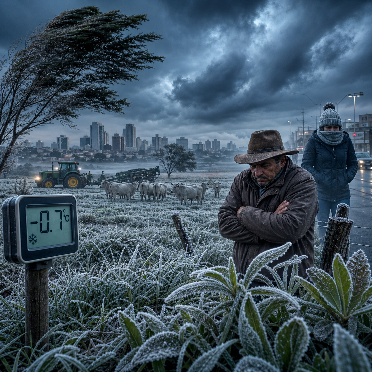
Polar mass advances over Mato Grosso do Sul, brings temperatures below 8°C and brings risk of frost and impacts on health and agriculture.
According to Climatempo, the most intense cold air mass of polar origin recorded in 2026 begins to enter through Rio Grande do Sul on the night of Sunday, April 26, progressively advancing north in the following days. The most severe core remains in the South on Monday and Tuesday, but the south and southwest of Mato Grosso do Sul enter the direct path of the polar air as the system advances.
The Weather and Climate Monitoring Center (Cemtec) has already issued alerts for a sharp decline in temperature and risk of frost in municipalities such as Amambai, Ponta Porã, Aral Moreira, Coronel Sapucaia, Iguatemi, Naviraí, and Paranhos.
Climatology of Mato Grosso do Sul explains why cold in April is considered an out-of-pattern event
To understand the impact of this episode, it is necessary to observe the typical climate pattern of the state. Mato Grosso do Sul has a well-defined climate regime, with hot and rainy summer between November and April and dry and milder winter from May to October. In April, temperatures still remain high.
-
Engineers Develop Fridge-Sized Machine to Produce 95-Octane Synthetic Fuel from Air and Water, Aiming to Sustain Combustion Engines Without Oil

-
Two-Armed Robot Uses AI to Reassemble Destroyed Pompeii Frescoes, Solving an “Impossible” Puzzle
-
New Law in Brazil Requires Breaks for Type 1 Diabetes Management at Work, School, and Public Exams

-
Scientists Confirm “Greening” of Antarctica: Ice on the World’s Coldest Continent Turns Green as Mosses Multiply Over Tenfold in Four Decades


The historical average of maximum temperatures in Campo Grande ranges between 28°C and 29°C, while the minimums generally do not drop below 20°C. Frost events during this period are rare and do not form part of the expected climate behavior.
Geography and topography facilitate the advancement of polar masses through the south of the state
The geographical configuration of Mato Grosso do Sul contributes to the entry of cold air in specific episodes.
The south-north axis and the relatively flat terrain allow polar masses to advance with less barrier when they present greater intensity.
Regions near the border with Paraguay, such as Ponta Porã and Iguatemi, are at a similar latitude to cities in the South of Brazil and can record significantly lower temperatures when the atmospheric system is strong.
Civil Defense and Inmet issue alert for drop greater than 10°C in less than 24 hours and risk of frost
The weather alerts indicate two main risks for the state. The first is the sharp decline in temperature, with drops greater than 10°C in less than 24 hours. The second is the risk of frost in at least 14 municipalities in the extreme south.
Among them are Amambai, Aral Moreira, Coronel Sapucaia, Eldorado, Iguatemi, Itaquiraí, Japorã, Laguna Carapã, Mundo Novo, Naviraí, Paranhos, Ponta Porã, Sete Quedas, and Tacuru.
Impact of cold on agriculture may affect second crop corn in critical development phase
Mato Grosso do Sul is one of the main producers of second crop corn in Brazil. In April, part of the crops is still in the grain filling phase, considered sensitive to low temperatures.

Frosts with temperatures below 3°C for prolonged periods can cause irreversible damage to plants, compromising productivity.
Campo Grande registers abrupt temperature drop and enters risk zone for public health
Campo Grande is located in an intermediate zone, receiving influence from polar air when the system is more intense.
The forecast indicates minimums between 8°C and 12°C, with a drop greater than 20°C compared to the temperatures recorded in the previous days.
This type of sudden variation has a direct impact on health, especially in populations not adapted to the cold.
Temperature oscillations increase the risk of respiratory and cardiovascular diseases
Medical studies indicate that rapid temperature changes are more dangerous than isolated extreme cold.
The sudden drop favors the worsening of respiratory diseases, such as bronchitis and pneumonia, in addition to increasing the risk of cardiovascular events. Small children and the elderly are the most vulnerable groups.
The Pantanal has its own climatic characteristics due to the large presence of water and vegetation. This condition can soften minimum temperatures compared to drier regions in the southern part of the state.
However, high humidity intensifies the thermal sensation, making the cold more uncomfortable for humans and animals.
Humid cold in the Pantanal may increase thermal stress in herds and affect productivity
In prolonged episodes of humid cold, cattle may show increased energy expenditure and greater susceptibility to respiratory problems.
These factors directly impact the productivity and health of herds, especially in extensive systems.
Climate models point to a scenario of greater thermal variability. Extreme heat events, with temperatures above 40°C, are expected to alternate with more intense incursions of polar air.
This increasing amplitude requires constant adaptation of productive systems and urban infrastructure.
Now we want to know: is Mato Grosso do Sul prepared to handle increasingly extreme climatic events?
The advance of polar masses outside the expected period reinforces the trend of increasing climatic variability.
In your view, is the state prepared to face these changes or is the risk likely to grow in the coming years?