Portuguese
  Spanish
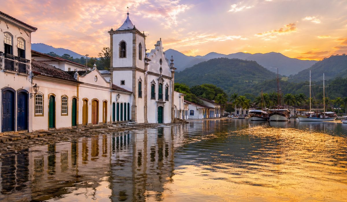
Historic city on the coast of Rio de Janeiro combines colonial heritage, tides that advance over stone streets, preserved Atlantic Forest, and international recognition in a list that compares villages from different continents.
Paraty, on the southern coast of Rio de Janeiro, was included by Forbes in the list of the 50 most beautiful villages in the world in 2025, curated by the Unforgettable Travel Company.
The city appears in 35th position and is the only Brazilian representative in the ranking, which has Bibury, in England, in first place.
The choice gave international visibility to a combination of a listed historic center, stone streets, colonial churches, traditional cachaça production, the Atlantic Forest, and a bay with dozens of islands.
-
Billionaire says the most valuable skill will help overcome job elimination caused by AI, following Bill Gates’ fears

-
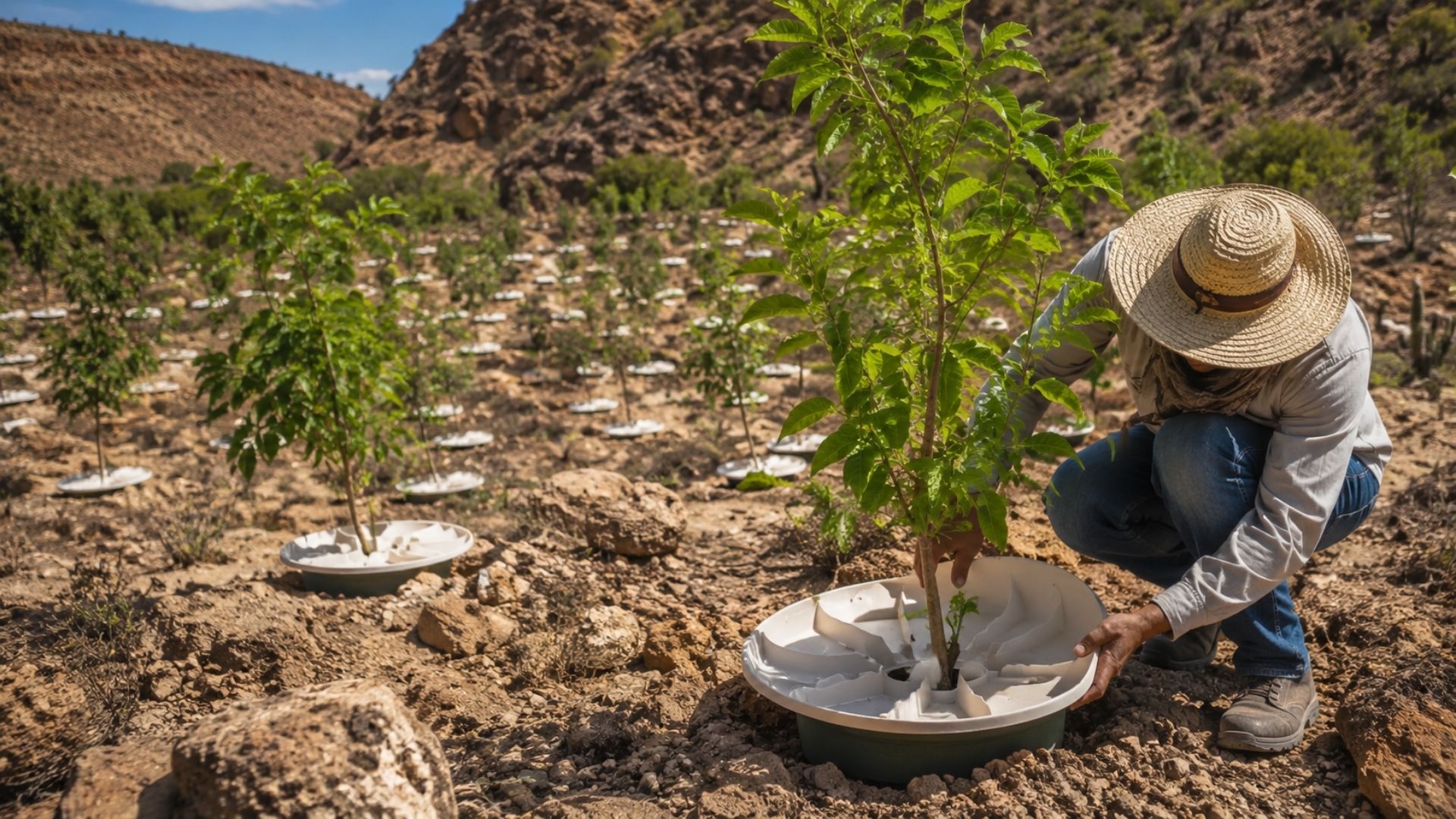
A Dutchman created a ‘box’ that makes trees grow in the desert almost without water and without irrigation: the invention has already brought seedlings to dozens of countries and achieves up to 90% survival where common planting did not exceed 10%.

-
Abandoned warehouse hid a giant collection of rare computers, with over 2,000 artifacts from the 1930s to the 1980s.
-
Scientists warn that melting ice is triggering an alarming chemical transformation in preserved areas, and the first signs are already concerning researchers worldwide.


Iphan also noted Paraty’s inclusion on the list and reported that the magazine highlighted the relationship between history, culture, and nature in the city.
In the Forbes Brasil article, Paraty is described as a destination on the coast of Rio de Janeiro that preserves colonial churches and stone streets.
The publication also mentions the boats that leave the pier heading towards Saco do Mamanguá, in addition to the trails, waterfalls, and the tradition linked to artisanal cachaça.
Forbes highlights Paraty among the most beautiful villages in the world
The list “The 50 Most Beautiful Villages in the World in 2025” was published by Forbes Brasil on September 21, 2025.
According to the magazine, the selection brought together places that go beyond traditional tourist routes and have historical marks and their own unique characteristics.
Paraty appears alongside destinations such as Hallstatt, in Austria, Reine, in Norway, Giethoorn, in the Netherlands, and Oia, in Greece.
The Brazilian city’s presence in the ranking was related to elements documented by the publication, such as the historic center, the colonial churches, access to Saco do Mamanguá, and cachaça production.

The municipality is located on the Costa Verde of Rio de Janeiro and combines a historic urban area with coastal landscapes and stretches of the Atlantic Forest.
This framework also appears in Unesco’s description for the Paraty and Ilha Grande site, which includes the historic center, protected areas of the Atlantic Forest, part of the Serra da Bocaina, and the Atlantic coastal region.
High tide in Paraty explains the sea’s advance into the historic streets
One of the best-known aspects of the historic center is the entry of seawater into certain streets during periods of high tide.
The phenomenon occurs in low-lying areas near the pier and is more noticeable on days with a greater tidal range.
The physical explanation is linked to the tidal cycle, influenced by the relative positions of the Moon, the Sun, and the Earth.
During the new moon and full moon phases, the spring tide usually produces more pronounced differences between high and low tide, which can increase the advance of water over low-lying coastal areas.

In Paraty, this natural behavior interacts with the old urban design.
The historic center preserves stone streets and colonial buildings built in an area directly connected to the port, a relationship that was recorded by Unesco when describing the conservation of the 18th-century urban layout and part of the colonial architecture of the 18th and 19th centuries.
The water that advances over the pavement is also one of the images that gave the city its tourist appeal.
However, the description of the phenomenon should be treated as the result of the combination of tide, coastal relief, and historical urban occupation, without asserting technical engineering details that have not been proven by an official source.
Paraty’s history involves the colonial port and the Estrada Real
The formation of Paraty is linked to its strategic position between the sea and the interior.
According to Unesco, at the end of the 17th century, the city was the final point of the Gold Path, a route used to transport gold to Europe.
The port also served as an entry point for tools and enslaved Africans sent to work in the mines.
The Old Path of the Estrada Real, associated with the route between Ouro Preto and Paraty, is about 710 kilometers long, according to the Estrada Real Institute.
Of the total, 320 kilometers consist of ascents and descents, with stretches of dirt road, asphalt, trail, and pavement.
With the change in economic routes throughout the colonial and imperial periods, Paraty lost some of its centrality as a port.
This process contributed to the preservation of old urban characteristics, recognized today in heritage listings and the inscription of the Paraty and Ilha Grande site on the World Heritage List.
The historic center was listed as a heritage site by Iphan in 1958.
Since 2019, Paraty and Ilha Grande have been on Unesco’s list as a mixed site, a category that recognizes cultural and natural attributes in the same property.

Paraty’s world heritage site combines culture and the Atlantic Forest
Unesco describes Paraty and Ilha Grande as a natural-cultural landscape that includes the historic center of Paraty, protected areas of the Atlantic Forest, part of the Serra da Bocaina, and the coastal region.
The organization also points out that the historic center has preserved its 18th-century urban plan and a significant part of the colonial architecture from the 18th and 19th centuries.
The recognized area involves six components, including the Historic Center of Paraty, Morro da Vila Velha, and conservation units such as the Serra da Bocaina National Park, the Cairuçu Environmental Protection Area, the Ilha Grande State Park, and the Praia do Sul State Biological Reserve.
From an environmental standpoint, Unesco reports that the region is located within the Atlantic Forest hotspot and has a high occurrence of endemic species.
The official description mentions, among other data, 450 registered bird species and the presence of threatened species, such as the jaguar and the southern muriqui.
This combination of architectural heritage and biodiversity helps explain why Paraty is analyzed by preservation agencies from two dimensions.
The city is not treated merely as a colonial complex, but as part of a landscape where territory, human occupation, forest, sea, and traditional communities are interconnected.
Paraty’s Cachaça has recognition linked to its territory
Cachaça is another element associated with the local identity.
In 2007, Paraty had been recognized with an Indication of Provenance for cachaça; on January 30, 2024, the INPI published the change of registration to Denomination of Origin.
According to the INPI, the change considered natural and human factors related to production.
The agency cites conditions such as the relief of the Serra do Mar, high rainfall, relatively high temperatures, and the characteristics of the sugarcane grown in the region, which influence aspects of the final product.
The update reinforces the link between territory and production technique.
In the case of Paraty, the cachaça is no longer identified solely by its geographical origin but is now recognized for specific characteristics of the environment and production method.
The local gastronomy also relies on elements of the Caiçara culture, fishing, and the relationship with the Atlantic Forest.
Dishes with fish, shrimp, banana, and regional ingredients are part of the tourist offering, although specific recipes vary among restaurants, communities, and events.
Tourism in Paraty requires preservation of the historic center and nature
Paraty’s inclusion in the Forbes ranking comes at a time when historic coastal destinations face debates about preservation, tourism, and climate events.
In the case of the Paraty and Ilha Grande site, UNESCO itself cites vulnerability associated with climate change and the recurrence of natural disasters.

The management of areas like this involves monitoring built heritage, visitor circulation, trail conservation, protection of environmental units, monitoring of coastal areas, and control of interventions in the historic center.
These are topics addressed by preservation agencies, public authorities, researchers, and local communities.
In the daily tourist experience, the visitor encounters a territory where different layers overlap.
The same itinerary can include a walk through the historic center, observing the tide in the stone streets, a boat trip through the bay, a visit to distilleries, and travel along stretches connected to the Estrada Real.
This combination explains Paraty’s presence on international lists without requiring the city to be presented as a static backdrop.
The recent recognition is linked to the way heritage, landscape, and traditional uses remain visible in an area that is still inhabited, visited, and subject to environmental and urban pressures.