

 Portuguese
  Spanish
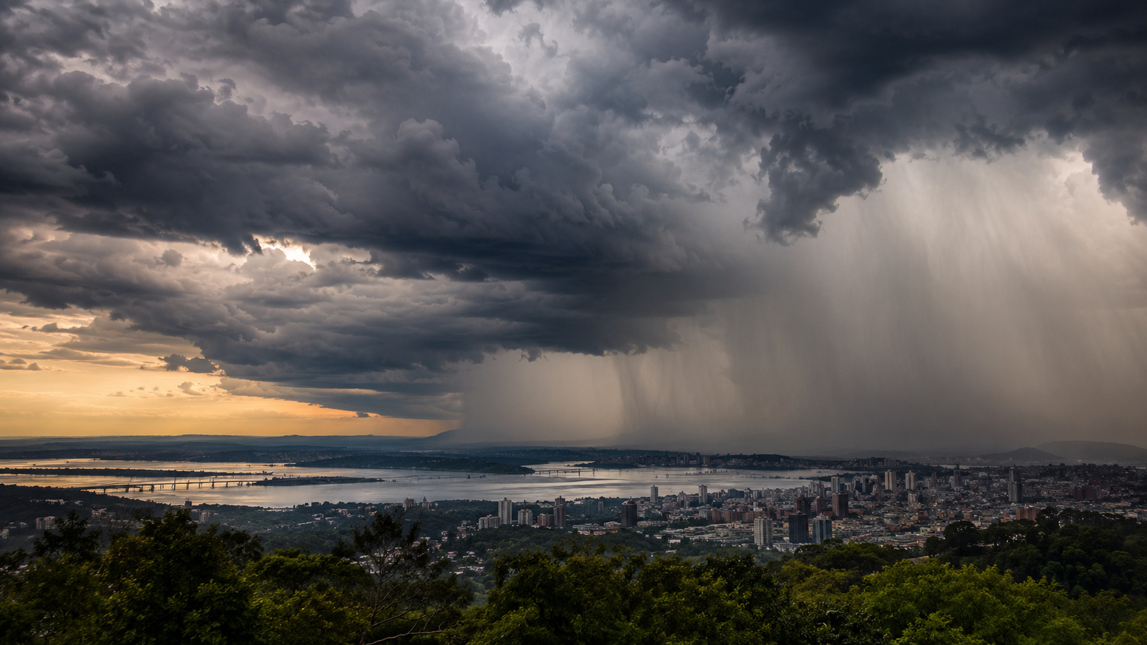
Forecast for the second half of 2026 indicates above-average rainfall in Southern Brazil, with increased risk due to consecutive months of saturated soil and full rivers.
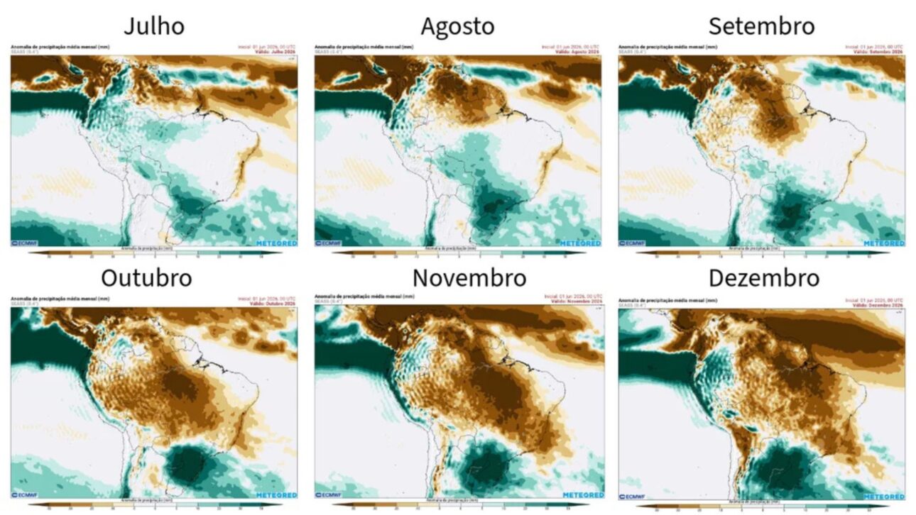
According to Tempo.com, based on the new seasonal forecast from ECMWF, the second half of 2026 is expected to have persistently above-average rainfall throughout the Southern Region of Brazil. The projected signal for July, August, September, October, November, and December indicates monthly anomalies exceeding 50 mm, which once again puts Rio Grande do Sul, Santa Catarina, and Paraná at the center of meteorological attention.
When this monthly surplus is summed over six months, the projected total may exceed 250 mm above the historical average for the semester. This number does not represent an isolated storm or a single extreme episode, but rather the repetition of months wetter than normal, a condition that increases hydrological risk because it saturates the soil, raises river levels, and reduces the landscape’s ability to respond to new storms.
Southern Brazil may record more than 250 mm of rain above average throughout the entire second half, according to a meteorologist’s warning. The number does not refer to an isolated storm or a single extreme event, but to the projected surplus accumulated for the period, considering the sum of expected monthly rainfall compared to the region’s historical average.
-
Science still debates how to measure the intelligence of someone who may be one of the most brilliant Brazilians of today, with an IQ of 188 recorded in a specific test, 55 cited qualifications, and membership in high IQ societies.

-
ALMA and James Webb telescopes reveal star-forming gas in ancient galaxies, and discovery shows a rare piece of cosmic history

-
OpenAI wants to transform ChatGPT into a powerful super app with AI agents, enhanced Codex, and tools for businesses before a potential billion-dollar IPO.
-
Alibaba launches artificial intelligence for robots in China and reveals why big techs now want machines that do much more than just talk


What the above-average rainfall forecast in the South really means
According to Tempo.com, the most important point of the projection is not just the final total, but the persistence of excess rainfall throughout the entire semester. In practical terms, this means the region may go through the second half of the year with a sequence of months wetter than historical climatology, creating an environment more vulnerable to floods and landslides.
This type of scenario is more concerning than an isolated data point might suggest. When above-average rainfall repeats for several months, the problem is not only the volume falling from the sky but also what has already accumulated on the ground.
With the soil saturated for weeks or months, just one intense event is enough for urban drainage to fail, rivers to overflow, and hillside areas to lose stability.
Why El Niño Increases Rain in the South and Dries Other Parts of Brazil
According to Greenpeace Brazil, El Niño is a natural climatic phenomenon associated with the abnormal warming of the surface waters of the Tropical Pacific, capable of altering wind patterns, atmospheric circulation, and rainfall distribution in various parts of the planet. In Brazil, this rearrangement usually divides the territory into opposing behaviors.
In the South, the most common effect is increased rainfall and the frequency of intense events, with a higher risk of floods and landslides.
Meanwhile, in the North, Northeast, and parts of the Midwest, the pattern usually favors reduced rainfall, higher temperatures, prolonged droughts, and worsening wildfires. In the Southeast and Midwest, the phenomenon can also intensify heatwaves and episodes of low humidity.
In the video below, the expert Ronaldo from Clima.Terra highlights among many important details the fact of 250 mm of rain in the southern region. This value refers to the total accumulation of the final months of the year, ECMWF warns of something around 50 mm per month.
This difference occurs because the warming of the Pacific reorganizes the atmospheric circulation over South America.
In practice, rain systems tend to become more favorable to the South, while other regions become more susceptible to moisture blockage. Therefore, the excess precipitation in the South of Brazil during El Niño episodes is not a coincidence, but a known atmospheric response to this type of oceanic warming.
The risk of excessive rain is real
According to Greenpeace Brazil, the expression “Super El Niño” is usually used when the sea surface temperature anomaly in the equatorial Pacific exceeds +2°C compared to the historical average. The term gained traction in public debate as it refers to very intense episodes from the past, but it does not replace the technical classification used by meteorological agencies.

The most important scenario for those living in the South is not the rhetorical strength of the expression, but the fact that the projected atmospheric signals point to a wetter second half than normal, with the potential to exacerbate impacts if persistence is indeed confirmed.
What is at risk with consecutive months of above-average rain in the South
According to Greenpeace Brazil, extreme events associated with El Niño can directly affect urban infrastructure, public health, agricultural production, water supply, energy, and mobility. In the South, this means that the concern is not limited to large cities. The problem reaches roads, rural areas, drainage systems, slopes, and entire production chains.
For agriculture, prolonged excess rain can hinder planting, management, and harvesting, as well as increase the risk of fungal diseases in crops sensitive to constant humidity.
For municipalities, the combination of already saturated soil with new intense rain events increases the chance of flooding, flash floods, and landslides.
For the electric sector, fuller reservoirs can be positive in part of the system, but peaks of concentrated precipitation can also damage structures and complicate operations.
The forecast is strong, but it is still a seasonal projection and not a closed certainty
According to Tempo.com, the new round of the ECMWF gained more weight because it was released after the so-called predictability barrier, a period when climate models tend to present greater uncertainty for the second half.
With this phase overcome, the projected signal for the South became more relevant and maintained the pattern of above-average rain.
The final volume of rain and the spatial distribution of events still depend on the interaction between the Pacific and other climatic factors, including the influence of other oceans and regional-scale atmospheric circulation.
The main message remains the same: the South of Brazil has a high chance of experiencing the second half of 2026 with above-average rainfall, and the best response is to use the advance notice to prepare crops, infrastructure, monitoring, and civil defense while there is still time to prevent some of the damage.


Be the first to react!