 Portuguese
  English
  Spanish
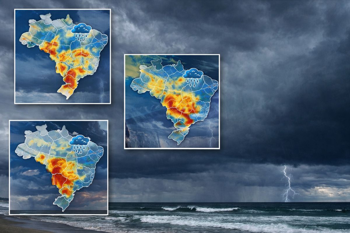
The cold front begins to act this Monday (13) and is expected to cause heavy rain, storms, and a drop in temperature in the South, Southeast, and Midwest. Between the end of April and the beginning of May, a mass of cold air may drop the minimum temperatures to around 8°C in elevated areas of Brazil.
A new cold front is arriving in Brazil this Monday (13) and is expected to change the weather in at least three regions of the country. The weather system is advancing over the South with forecasts of heavy rain, risk of storms, strong winds, and lightning, and its effects are expected to extend to the Southeast and Midwest in the following days. The cold front does not act in isolation: it interacts with the heat and humidity already present in the atmosphere, which favors the formation of heavy clouds and increases the potential for more intense precipitation than usual for this time of year.
The instability will not be temporary. According to Canal Rural, the trend is for increased rainfall volumes until Wednesday (15), with intensification between April 16 and 20 in the Midwest and a return of rains to the Southeast and South between April 21 and 25. In addition to precipitation, the cold front paves the way for a mass of cold air expected between the end of April and the beginning of May, which may lead minimum temperatures to around 8°C in higher altitude areas. For those who thought the heat would last, the change will be abrupt.
When the cold front begins to impact Brazil
According to the portal ndmais, the change in weather begins to be felt this Monday (13), with the gradual advance of instability areas over the South of the country. The cold front moves from southwest to northeast, pushing the warm air upward and creating conditions for stronger rains as it advances. In the early hours, the impact is concentrated in Rio Grande do Sul and Santa Catarina, but the system quickly expands to Paraná and then to the southern part of the Southeast.
-
China creates a capsule with artificial intelligence that scans the stomach in just 8 minutes and can reduce costs by up to R$ 1,400, paving the way for a new era of gastrointestinal diagnostics without tubes, sedation, and discomfort for patients.

-
Scientists simulate nuclear fireball in the laboratory and discover a surprise in the radioactive fallout by observing how cesium, uranium, and cerium change when they remain at high temperatures for a longer time.

-
The Earth’s magnetic pole has decided to “take a trip” towards Russia, getting closer and closer to Siberia, and forcing scientists to update the model used by GPS, airplanes, ships, and military systems worldwide.
-
An underwater volcano on the seafloor off Oregon is showing clear signs of impending eruption, and scientists are observing everything in real-time.


Throughout the week, the cold front loses speed but gains amplitude. Between Tuesday and Wednesday, the rains spread through the interior of São Paulo, Minas Gerais, and Mato Grosso do Sul, while the Midwest begins to feel the effects of the combination of tropical humidity and instability brought by the system. The forecast is for significant rainfall accumulations in several of these areas, with a risk of flooding in urban regions where drainage is poor.
Which regions will the cold front hit hardest
The South is the first region to feel the effects and also faces the most immediate risks. The forecast includes heavy rain with a risk of storms, strong winds, and lightning, especially in the west and center-south of Rio Grande do Sul and Santa Catarina. In Paraná, impacts are expected between Monday and Tuesday, with downpours concentrated in the west and southwest of the state.
In the Southeast, the cold front acts less intensely but still significantly. The increase in cloud cover and rain showers should concentrate in the southern part of the region, affecting areas of São Paulo, Paraná, and southern Minas Gerais. In the Midwest, the combination of heat, humidity, and the instability brought by the cold front creates conditions for stronger rains, particularly in Mato Grosso, where accumulations may be high between April 16 and 20.
What to expect from the rain over the next few weeks
The cold front marks the beginning of a prolonged period of instability that is expected to extend until the end of April. Until Wednesday (15), the highest volumes of rain should concentrate in the North and part of the Northeast, influenced by the Intertropical Convergence Zone (ITCZ), while the South and Southeast face the more direct effects of the frontal system. The coast of Bahia also comes into the radar of instabilities, with high precipitation volumes expected in the coming days.
Between April 16 and 20, the scenario intensifies in the Midwest. Mato Grosso, northern Northeast, and Pará are expected to experience frequent rains and high accumulations. Between April 21 and 25, precipitation gains even more strength, with the advance of instabilities over Goiás and a return of rains to the Southeast and South. This period raises the risk of flooding and rising river levels in urban areas, a particularly relevant alert for cities that have already faced drainage problems this year.
The drop in temperature that the cold front will cause
In addition to the rain, the cold front brings a drop in temperature that will be felt especially in the first days of the system’s action. The thermometers are expected to register a significant drop in the South and Southeast, with lower minimums than those observed in recent weeks. After the passage of the cold front, temperatures will gradually rise again, especially in the South Region, but this warming will be temporary.
The most relevant data for those planning the coming weeks is that a new mass of cold air is expected between the end of April and the beginning of May, which could lead minimum temperatures to around 8°C in higher altitude areas. Mountainous regions of the South and Southeast are the most vulnerable to this drop, but even lower altitude cities may feel the cooling. For those who have already stored their blankets, the recommendation is to take them back out of the closet.
What explains the change in weather caused by the cold front
The cold front is a weather system that forms when a mass of cold air advances and pushes warm air upward. This dynamic favors the formation of heavy clouds, thunderstorms, and intense precipitation, especially when the displaced warm air contains a lot of moisture, as is the case during this transitional period between summer and autumn. In the current scenario, the cold front acts in conjunction with high humidity and other atmospheric phenomena, which amplifies the effects in various regions.
The seasonal transition explains why this type of event is more frequent between April and May. As autumn progresses, cold air masses become more frequent and intense, pushing instability further north in the country. The pattern that is shaping up for the coming weeks suggests a sequence of cold fronts interspersed with brief periods of stability, a typical behavior of the beginning of the Brazilian autumn that may persist until June.
The cold front arrives this Monday and is expected to bring heavy rain, storms, and cold of up to 8°C in three regions of Brazil. Have you already felt the change in the weather? Do you think this autumn will be colder than normal? Tell us in the comments how the forecast is in your city.


Be the first to react!