Portuguese
  Spanish
Low pressure system can cause more than 100 mm of rain in RS before polar air mass, with risk of storms, hail, and strong winds.
In April 2026, the National Institute of Meteorology (Inmet) warned, in Meteorological Bulletin No. 16/2026, published on April 20, about the formation of a low pressure system over the Southern Region, with the potential to cause a sudden change in weather conditions, especially in the west of Rio Grande do Sul. According to the official bulletin, rainfall accumulations in the area could exceed 100 millimeters in the first days of the week, with a risk of storms, gusts of wind, lightning, and hail.
The scenario was reinforced by analyses released by Climatempo on April 22 and 23, which indicated the advancement of instabilities over the gaucho territory, with moderate to heavy rain, isolated storms, and high accumulations, especially in the west, center, and northern half of the state. The company also highlighted the combined action of low-level jets, atmospheric troughs, and a low pressure area, elements that increase the organization of storms in the South of the country.
MetSul Meteorologia, in analyses published between April 21 and 23, also associated the instability with the presence of low pressure and a semi-stationary cold front, indicating that the atmospheric pattern favored persistent rain and locally strong episodes in Rio Grande do Sul. This type of configuration is typical of severe weather events concentrated in a short period, increasing the risk of disruptions in urban and rural areas.
-
Scientists Develop Method to Store Wind and Solar Energy by Liquefying Air for On-Demand Power Generation

-
Brazilian Engineer Who Grew Up Without Electricity Develops Software, Expands AltoQi to 67,000 Clients, Aiming for $21 Million by Digitizing Brazil’s Construction Industry

-
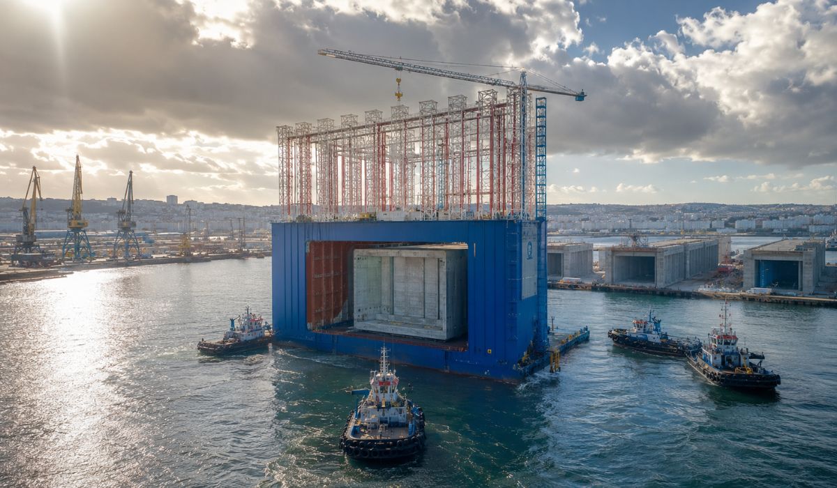
Spain Launches World’s Largest Floating Dry Dock: 56-Meter Giant Produces Massive Concrete Structures in A Coruña Using Technology Proven in Brazil

-
AI-powered toys that talk, recognize faces, and collect data face scrutiny from Brazilian government over children’s privacy concerns


What is a low pressure system and why does it generate intense storms
A low atmospheric pressure system is characterized by a region where warm, moist air tends to rise rapidly. This upward movement favors the formation of dense cumulonimbus clouds, responsible for strong storms.

In the case observed in Southern Brazil in April 2026, the low pressure acts in conjunction with other meteorological factors:
- The presence of warm, moist air coming from the Amazon region
- The advancement of a cold air mass from the south of the continent
- The interaction between wind currents at different levels of the atmosphere
This combination creates a highly unstable environment, in which the atmosphere becomes conducive to the formation of organized storms.
The greater the contrast between warm and cold air masses, the greater the intensity of the storms, especially when there is a high availability of moisture.
Forecast of more than 100 mm of rain concentrates risk in the west of Rio Grande do Sul
According to INMET, the highest volumes of rain are expected to concentrate in the west and central region of Rio Grande do Sul, areas that already have a history of extreme events associated with low pressure systems.
The predicted accumulations exceed 100 millimeters in a few days, which represents a significant amount of precipitation for a short period. For comparison, this volume can be equivalent to almost the entire monthly average of rain in some cities in the region.

This type of accumulation raises the risk of flooding, river overflow, and damage to urban and rural infrastructure, especially in areas with limited drainage or already saturated soil.
Additionally, the intensity of the rain may vary locally, with storm cores capable of producing even higher volumes in specific points.
Hail, lightning, and wind gusts reinforce severe weather scenario
In addition to voluminous rain, the forecast indicates the occurrence of phenomena typical of severe storms. Hail is one of the main risks associated with this type of system. It forms within storm clouds when intense updrafts keep ice particles suspended, allowing them to grow before falling.
Frequent electrical discharges, resulting from the accumulation of charges within the clouds, and strong wind gusts, which can exceed 60 km/h in some more intense episodes, are also expected.
The combination of these factors increases the potential for damage, including fallen trees, unroofing, and impacts on the power grid.
Abrupt transition paves the way for the arrival of a cold air mass
One of the most relevant aspects of this low-pressure system is that it precedes the entry of a polar cold air mass, expected to advance over Southern Brazil in the following days.
This sequence is common in atmospheric dynamics:
- First, an area of instability associated with low pressure forms
- Then, the cold front advances, organizing rain and storms
- Subsequently, cold air enters, dropping temperatures
This pattern creates a rapid and striking change in weather, transitioning from warm and unstable days to a scenario of intense cold in just a few days.
Potential impacts affect agriculture, transport, and urban areas
The effects of such a meteorological event go beyond atmospheric conditions and directly impact strategic sectors.
In agriculture, excessive rain can harm crops, hinder harvests, and affect the soil. Hail, on the other hand, poses a direct risk to sensitive crops.
In transport, intense storms can cause disruptions on highways and affect air operations, especially at airports in the South of the country.
In urban areas, the main risk is related to floods, power outages, and structural damage. These impacts make meteorological monitoring essential for preventive decision-making.
History shows that similar systems have already caused extreme events in the South
Events associated with low-pressure systems are not uncommon in Southern Brazil, but their intensity can vary significantly. In previous years, similar episodes have already caused:
- Rainfall above 150 mm in a few days
- Storms with large hail
- Wind gusts capable of causing structural damage
The pattern observed in April 2026 presents characteristics compatible with these events, which reinforces the need for attention. The recurrence of these systems shows that they are part of the region’s climatic dynamics, but it does not eliminate the risk associated with each specific occurrence.
Interaction between air masses reinforces instability in the South of the country
Another important factor to understand the scenario is the interaction between different air masses. The presence of warm and humid air in central Brazil creates a high energy base in the atmosphere. When this air encounters a cold air mass advancing through the South, a sharp thermal contrast occurs.
This contrast favors the formation of more intense instabilities, with greater potential for severe storms. This mechanism is one of the main reasons for the intensity of the events predicted for the end of April.
Meteorological monitoring allows anticipating risks and reducing impacts
The forecast of events like this is the result of significant advances in meteorology. Numerical weather prediction models, combined with satellite data and meteorological stations, allow identifying instability patterns in advance.

Institutions like INMET and private centers constantly update their projections, adjusting scenarios as new data is incorporated. This continuous monitoring is fundamental for alerting the population and guiding preventive actions.
Given this scenario, how can events like this repeat throughout the year
The occurrence of a low-pressure system followed by cold air ingress raises an important question about climate behavior throughout the year. Similar events can repeat, especially during transitional periods between seasons, when air masses with different characteristics interact more frequently.
With the advancement of monitoring and forecasting technologies, the ability to anticipate these phenomena increases, but the challenge of dealing with their impacts remains.
Given increasingly intense and concentrated episodes, the question that arises is clear: how are cities, producers, and infrastructure systems preparing to face abrupt weather changes that can occur in a matter of hours?