
 Portuguese
  Spanish
On June 22, 2013, UNESCO announced the inscription of the Honghe Hani Rice Terraces in southern Yunnan. The rice staircase covers 16,603 hectares, was shaped by the Hani people for 1,300 years, and relies on villages, forests, and community channels against droughts, tourism, and local landslides.
A rice staircase carved into the mountains of China over approximately 1,300 years has transformed the slopes of Yunnan into a monumental agricultural system. The Honghe Hani Rice Terraces descend the Ailao mountains to the banks of the Hong River, forming irrigated layers that resemble steps between forests, villages, and narrow valleys.
International recognition came in 2013, when the UNESCO World Heritage Committee inscribed the Cultural Landscape of Honghe Hani Rice Terraces on the World Heritage List. The same landscape that impresses with the harmony between people and environment also faces pressures: growing tourism, risk of landslides, and vulnerability of farmers’ permanence on the land.
An agricultural work shaped over 1,300 years
The terraces were created by the Hani people, who transformed areas of dense forest into irrigated rice fields. According to UNESCO, this collective construction developed over about 1,300 years, following the contours of the mountains and responding to an environment of narrow valleys, ravines, and heavy rains.
-
The largest Gothic church in Northern Europe began in 1248 to house the relics of the Three Wise Men, remained unfinished for centuries, and was only completed 632 years later, with steel, steam, and a German national campaign that turned the delay into a historical symbol.

-
A city in India was inaugurated in 1968 in front of 5,000 people, welcomed young people from 124 nations, and today gathers more than 3,300 residents from 60 nationalities trying to prove that humanity can live without divisions of country, religion, and politics.
-
An abandoned weapons factory that still contains ammunition and military vehicles has been discovered.
-
Businessman puts modern 1,100 square meter fortress in Russia up for sale for $550,000, featuring high walls, archer towers, a 1.2-hectare plot, and an isolated location on the banks of the Don River.


In some places, the rice staircase gathers up to 3,000 terraces between the lower part of the forests and the valley floors. The result is not just a beautiful landscape, but a traditional agricultural technology based on water, terrain, community work, and accumulated knowledge.
Where the Honghe Hani Rice Terraces are located
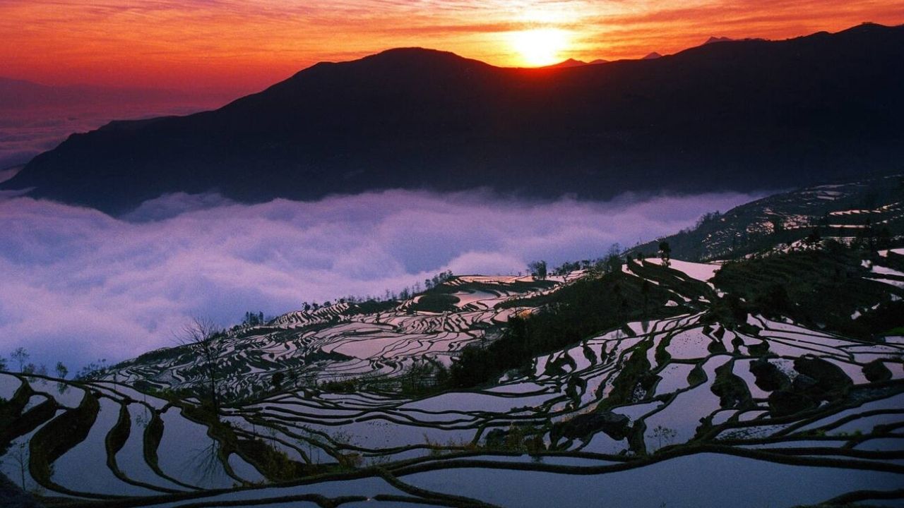
The cultural landscape is located in the south of Yunnan province, in the mountainous terrain of the Ailao mountains, south of the Hong River. The UNESCO news of June 22, 2013, reports that the inscribed area covers 16,603 hectares.
The technical decision also describes three main terrace areas: Bada, Duoyishu, and Laohuzui. They are in different basins and have varied slopes. In Bada, the terrain is gentler; in Duoyishu, steeper; in Laohuzui, the slope is very steep.
Forests at the top function as a natural water reservoir
The Hani system depends on a direct relationship between forests, water, terraces, and houses. The forests at the top of the mountains capture and sustain the water needed to irrigate the rice fields along the slopes.
UNESCO identifies different types of forest in the landscape, including ancient water recharge areas, sacred forests, consolidation forests, and village forests. Without this vegetation cover at the top, the rice staircase would lose part of the natural mechanism that keeps irrigation functioning.
Community canals spread water through mountains and valleys
Water reaches the terraces through a complex system. Cracks in the rocks conduct rain, while sandstone layers under granite mountains help store and release water in the form of springs.
Based on this natural functioning, the Hani developed a network of canals to distribute water between terraces and valleys. UNESCO records four main canals and 392 branches, totaling 445.83 km, maintained communally. This traditional engineering is what keeps agriculture alive on the slopes.
Villages were built between forests and rice fields
The landscape includes 82 relatively small villages, with about 50 to 100 families each. They are located above the terraces and just below the forests at the top of the mountains, in a territorial organization directly linked to water use.
The traditional houses have walls of compacted earth, adobe, or stone and earth, with high thatched roofs that give a “mushroom” appearance. According to UNESCO, at least half of the village houses are still made wholly or partially with traditional materials.
Red rice sustains a living agricultural culture
Red rice is the main crop of the terraces. UNESCO describes an integrated agricultural system in which rice cultivation is related to animal husbandry, water management, community practices, and ancient social and religious structures.
This set is important because the landscape does not function solely as a plantation. It expresses a way of living where agriculture, village, forest, spirituality, and social organization mutually reinforce each other for many generations.
Religious traditions also protect the landscape
UNESCO highlights that the Hani people maintain social and religious structures linked to respect for nature. Above the villages, there are places associated with the village god, called Angma, and the earth’s protective god, Misong.
In these spaces, residents pray for peace, health, and prosperity. This aspect helps explain why the rice terrace is considered cultural heritage, not just an agricultural work. The value lies both in the landscape and in the knowledge and rituals that maintain it.
System withstood drought, but remains exposed to landslides
UNESCO’s assessment states that the terraces demonstrated high resilience against climate change and drought, including during the great drought of 2005. This point reinforces the strength of traditional water management in the mountains.
But resilience does not eliminate all risks. UNESCO itself warns that the terraces are vulnerable to landslides, as they were built on slopes with an average inclination of 25%. The ancestral work overcame droughts, but it remains dependent on the stability of steep mountains.
Growing tourism may pressure villages and customs
In 2013, UNESCO recorded that tourism had not yet generated significant adverse impacts, but the number of visitors was rapidly increasing. The organization pointed out the need for infrastructure and tourism management to prevent the villages from being overwhelmed.
This is a common dilemma in visually impressive heritage sites. Tourism can generate income, but it can also alter routines, pressure housing, increase service costs, and transform living communities into a backdrop for visitors. The rice terrace needs protection precisely because it is still inhabited and cultivated.
Risk of Rural Abandonment Also Appears in the Alert
UNESCO points out vulnerability in the capacity of the agricultural and forestry system to ensure sufficient income for farmers to remain on the land. This alert brings the heritage closer to a contemporary problem: the difficulty of keeping young people and families in the countryside.
If the production of red rice ceases to sustain local life, the risk is not only economic. The loss of farmers can weaken the maintenance of channels, terraces, traditional houses, and community rituals. When those who care leave, the landscape begins to lose its living foundation.
Traditional Houses Face Pressure from Modern Materials
The authenticity of the landscape was recognized by the continuity of traditional forms, agricultural practices, local knowledge, and customs. However, UNESCO also noted risks related to the replacement of materials in housing.
Concrete blocks instead of adobe and tiles instead of thatched roofs have begun to change the appearance of the villages. The introduction of external architectural styles was also pointed out as a negative impact factor on the traditional image of the landscape.
Protection Depends on Management Until 2030
The area is protected by China’s legal instruments and was designated in 2008 as a historic site protected by the Yuanyang county government. UNESCO also cites local rules, conservation plans, and village norms to control construction, preservation, and management.
The management plan mentioned runs from 2011 to 2030, with short, medium, and long-term goals. It involves local agencies, committees, and specialized administration to take care of the terraces, forests, villages, irrigation systems, and traditional culture.
When a Landscape Only Survives if It Continues to Be Lived
The Honghe Hani Rice Terraces impress because they look like a giant sculpture in the mountains, but their real strength lies in the daily work of the communities that still cultivate, maintain channels, respect forests, and preserve ancient practices.
The lingering question is difficult: should places like this rice staircase receive more visitors to generate income or need strict limits to protect villages, farmers, and traditions?
Do you think it’s possible to preserve a living heritage without turning the community into a tourist attraction? Leave your opinion in the comments.


Be the first to react!