Portuguese
  Spanish
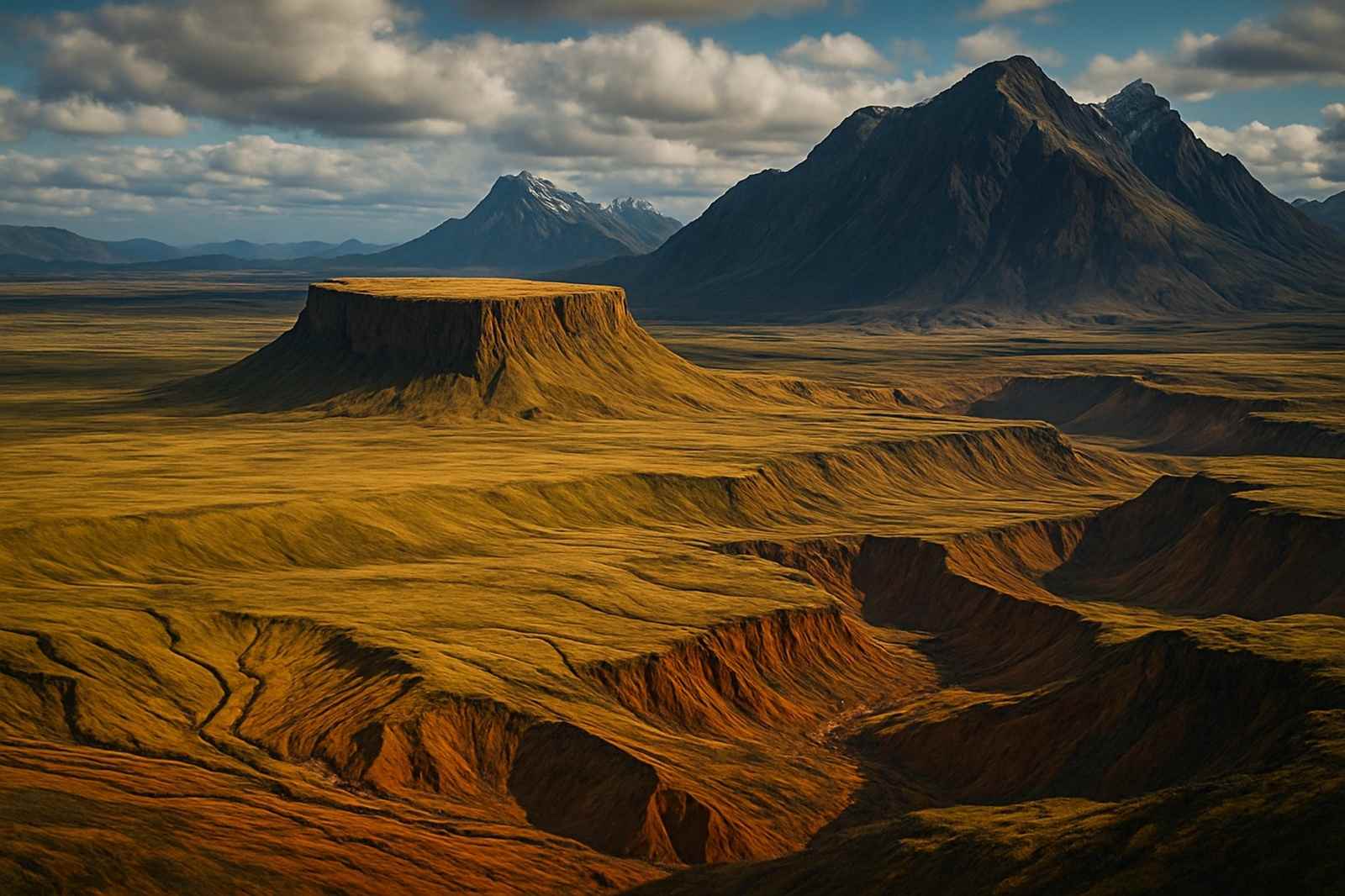
Forms Such As Plateaus, Plains, Depressions, And Mountains Result From Natural Processes That Include Erosion, Sedimentation, And Tectonic Movements. These Structures Shape The Earth’s Surface And Help To Understand The Dynamics Of The Lithosphere In Different Regions
The relief corresponds to the aspect of the Earth’s surface layer, the lithosphere, and presents marked variations with plateaus, plains, depressions, and mountains.
These forms arise from natural action that takes place over time, whether in short intervals or over millions of years.
The movement of tectonic plates and erosion caused by water and wind directly influence these changes. The area of Geography dedicated to the study of these structures is Geomorphology.
-
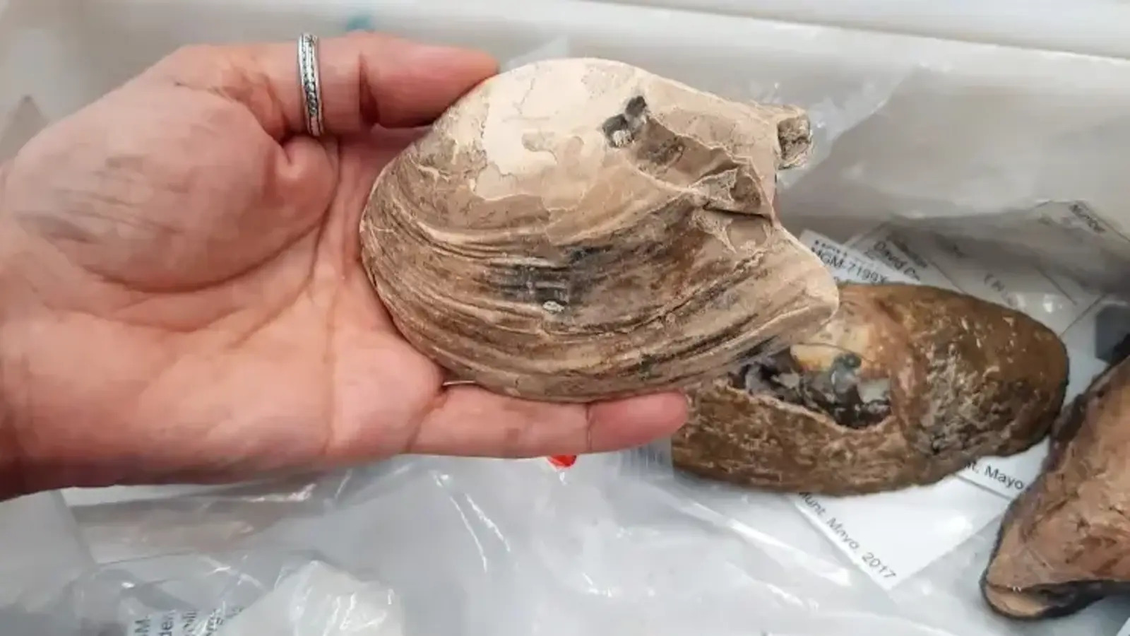
Scientists Discover 125-Million-Year-Old “Pregnant Fossil” with Preserved Embryos and Microscopic Larvae Inside Mollusk in England

-
17-Year-Old Justin Bernstein Develops Bacteria to Produce Glass on Arctic Ice to Reflect Sunlight, Wins $50,000 U.S. Scholarship

-
The 19-Meter Rocket-Helicopter: A Private Industry Prototype That Challenged Space Race Logic

-
Brazilian Students Convert Seized Illegal TV Boxes into Linux-Powered Mini Computers for Schools and Social Projects Across São Paulo


Plateaus
Plateaus are elevated and relatively flat surfaces with steep slopes and well-defined boundaries. There, erosion predominates because there is a constant loss of sediments. The altitude of this type of relief can vary from 300 meters to over 2000 meters, depending on the region.
Among the plateaus, three main types stand out. The sedimentary plateaus are composed of sedimentary rocks accumulated over time.
The crystalline plateaus are formed by metamorphic and magmatic rocks that arise from the wear of ancient mountains. The basaltic plateaus result from volcanic eruptions that create layers of specific rocks.
Some expressive examples include the Antarctic Plateau, located in Antarctica, the Patagonia Plateau, located between Argentina and Chile, and the Tibetan Plateau, which extends across China. These regions exemplify the diversity of conditions capable of giving rise to elevated surfaces.
Plains
Plains are essentially flat, slightly undulating areas of low altitude. Their formation process is based on sedimentation, characterized by the accumulation of sediments that come from higher regions, where erosion is more intense. For this reason, plains are considered landforms in constant construction.
It is common for these areas to be near mountains and plateaus, as they depend on material transported from these regions.
Among the main types are coastal plains, formed by sediments coming from the sea, river plains, originated from deposits left by rivers, and lacustrine plains, which are formed by sedimentation in lakes.
Some important examples are the Pannonian Plain, located in Central Europe, the Jeffara Plain, which extends between Tunisia and Libya, and the Pantanal Plain, present in Brazil and small areas of neighboring South American countries.
It is worth noting that a plain and a sedimentary basin are not equivalent, as the former is a landform, while the latter is a geological structure.
Depressions
Geographical depressions correspond to surfaces with lower altitudes compared to neighboring areas. There, erosion predominates, just as it does in other landforms. This type can appear near mountains, plateaus, and plains, creating remarkable transitions in the landscape.
There are two main types of depressions. The absolute depression is below sea level, placing it among the deepest regions of the planet. The relative depression is above sea level but located at a lower point than the nearby elevations.
Among the best-known examples are the Cuiabana Depression, located in the central region of Brazil, the Caspian Sea, situated between Europe and Asia, and the Dead Sea, positioned between Israel, Palestine, and Jordan in the Middle East.
Mountains
Mountains represent elevated forms with altitudes higher than the surrounding areas. The highest point is called a peak and stands out for its sharp elevation compared to the surroundings. The formation of mountains occurs from earthquakes and volcanic eruptions resulting from the movement of tectonic plates.
This relief can be classified into three main types. Volcanic mountains emerge from eruptions that accumulate rocky material.
Faulted mountains appear due to geological faults that uplift blocks of rocks. Folded mountains are a direct result of tectonic plate movements that compress and deform materials.
Examples include Mount Everest, located in the Himalayas between Nepal and China, Mount Fuji, situated between the provinces of Shizuoka and Yamanashi in Japan, and Mount Olympus, in the mountain range of the same name in Greece.
Other Landforms
In addition to the main classifications, other structures complete the diversity of the Earth’s relief. The escarpment is a steep slope, usually related to plateaus. A cuesta presents a differentiated slope, with one side gentle and the other steep.
A tableland, also known as a tabular plateau, has a flat-topped surface. A mountain range combines different forms into a single surface. Ainselberg appears as an isolated rocky elevation, typical of arid and semi-arid regions.
Reliefs in Brazil
In Brazil, three forms of relief predominate: plains, plateaus, and depressions. Among the main plains are the Pantanal, the Amazon Plain, and the Coastal Plain. Among the plateaus stand out the Amazon Plateaus, the Parecis Plateau and Chapada, and the Guimarães Plateau.
The most significant depressions are the Sertaneja and São Francisco Depressions, the Peripheral Depression of the Eastern Border of the Paraná Basin, and the Northern Amazonian Marginal Depression. The Brazilian territory also features tabular plateaus, tablelands, and mountain ranges, such as the Coastal Tablelands, the Chapadas of the Mid-North, and the Mantiqueira Mountains.