Portuguese
  Spanish
Inmet issued a danger alert for Santa Catarina, Paraná, Mato Grosso do Sul, and São Paulo this Sunday (26) due to an extratropical cyclone formed off the coast of Rio Grande do Sul and Uruguay. The forecast includes winds of up to 100 km/h, accumulated rainfall of 100 mm in a single day, and risk of hail, floods, roof damage, and falling trees in over 50 cities in Santa Catarina and dozens of municipalities in the other three states.
An extratropical cyclone formed off the coast of Rio Grande do Sul and Uruguay is advancing over four Brazilian states this Sunday with destructive potential that led Inmet to issue a danger alert for regions of Santa Catarina, Paraná, Mato Grosso do Sul, and São Paulo. The Santa Catarina Civil Defense confirmed that the rain can be punctually intense with isolated storms in all regions of the state, accompanied by lightning, wind gusts, and hail. The winds can reach 100 km/h and the volume of rain can reach 100 millimeters in a single day.
Instability was already present in the early hours of the morning in western Santa Catarina and in areas bordering Rio Grande do Sul. In the coming hours, the storms are expected to intensify and advance to other regions, including the Itajaí Valley, northern Santa Catarina, and the Serra region. The risk, according to Civil Defense, is low to moderate for occurrences such as floods, localized flash floods, falling branches and trees, roof damage, and damage to the electrical grid. For residents of affected areas, Sunday requires heightened attention and immediate preventive measures.
Which states and regions are in the path of the extratropical cyclone

According to information released by the NSC portal, Inmet’s danger alert covers specific regions in each of the four affected states. In Santa Catarina, 50 cities are in the path, including Joinville and Blumenau, with emphasis on Western Santa Catarina, Northern Santa Catarina, the Itajaí Valley, and the Serra region. In Paraná, the list is even more extensive, covering the Curitiba Metropolitan Region, the West, Southwest, Northwest, and central areas of the state.
-
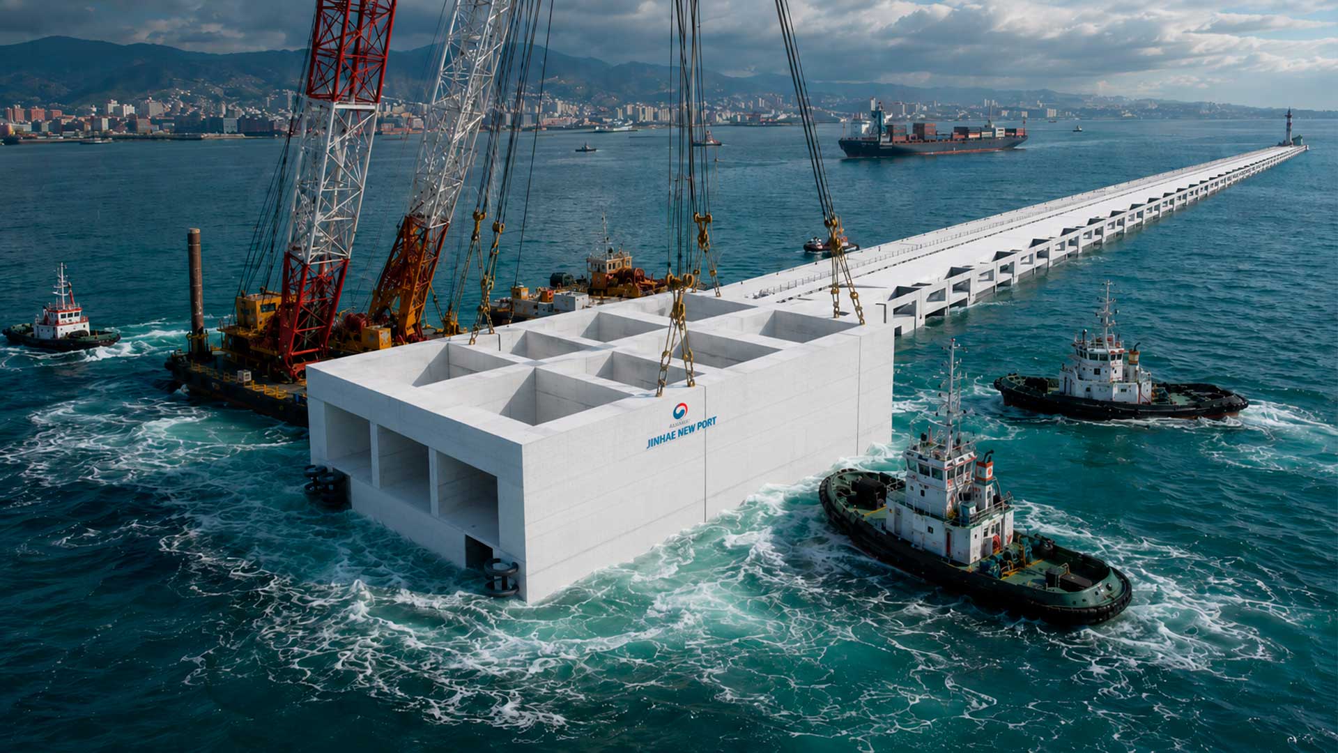
South Korea to Sink 20 Massive Concrete Coffers Off Busan Coast to Build 1.4 km Breakwater at Jinhae New Port, Part of $9.4 Billion Expansion to Rank Among World’s Top 3 Ports

-
Venice Deploys 78 Massive Steel Gates to Shield City from Extreme Adriatic Tides

-
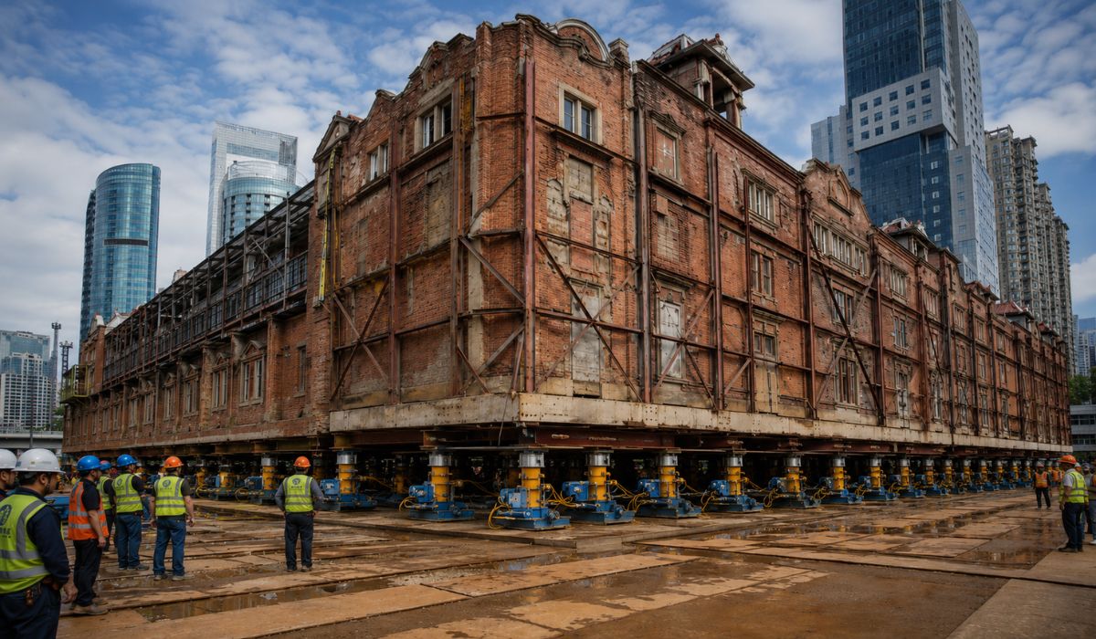
China Uses 432 Robots to Move a 7,500-Ton Historic Building in Shanghai, Preserving Architecture While Creating Space for Underground Center
-
World Cup Ball Chip Uses Technology to Detect Invisible Touches, Confirms Offside, Secures Portugal’s Victory Over Croatia


In Mato Grosso do Sul, the alert regions include the Southwest, the South Mato Grosso Pantanal, and the East of the state. In São Paulo, the affected areas are concentrated in Itapetininga and the South Paulista Coast, regions that lie in the path of the cold front associated with the cyclone. The simultaneous coverage of the alert across four states reflects the scale of the meteorological system, which intensified as it moved from the Argentine and Uruguayan coast towards Brazilian territory.
What the cyclone can cause: winds, rain, hail, and floods
The combination of winds up to 100 km/h with accumulated rain of 100 mm in one day creates conditions for significant damage in urban and rural areas. Gusts of this intensity are sufficient to knock down trees, tear off roofs, overturn road signs, and cause prolonged power outages. The predicted volume of rain can saturate the soil and drainage systems, causing floods in low-lying areas and flash floods on slopes.
The risk of hail adds a layer of concern. Hailstones can damage vehicles, crops, roofs, and unprotected structures in a matter of minutes, and the forecast for isolated storms makes it difficult to predict exactly where the hail will fall. For rural producers in Santa Catarina and Paraná, the possibility of crop loss due to hail in late May is a scenario that requires early protection when possible.
Why the extratropical cyclone formed and how it moves
The **cyclone** originated from a cold front that advanced along the **coast** of Rio Grande do Sul and Uruguay, gaining energy by interacting with the relatively warm waters of the South Atlantic. **As the system deepens, it organizes the counter-clockwise wind circulation**, pulling moisture from the ocean and cold air from the southern continent in a dynamic that produces severe instability in the affected area.
The **cyclone**’s movement continues from Southwest to Northeast, which explains the sequence of affected **states**: first Rio Grande do Sul, then **Santa Catarina** and **Paraná**, and finally **Mato Grosso do Sul** and **São Paulo**. **The intensification of the system in the open sea maintains the supply of moisture and energy that sustains the storms** for hours on end, unlike convective storms that form and dissipate quickly. The result is a prolonged event that can affect the same regions for more than 24 hours.
What to do during Inmet’s danger alert
The Civil Defense of **Santa Catarina** issued specific recommendations for the population during the **alert** period. **In case of strong winds, the guidance is to avoid walking or seeking shelter near trees, signs, walls, and power poles**, which can collapse under the pressure of gusts. During **storms**, the recommendation is to seek shelter, away from windows and objects that could be thrown.
For situations of intense **rain** with **flooding**, the rule is categorical: never cross flooded streets or submerged bridges and culverts. **The force of moving water can drag vehicles and people even in seemingly shallow levels.** The Civil Defense can be called by phone 199, and **Inmet** maintains constant updates of alerts on its website and app, allowing residents of affected areas to follow the evolution of the **cyclone** in real time.
What to expect in the coming hours and when the weather improves
The most intense **storms** are expected to occur throughout this Sunday and extend until Monday (27) morning in the regions covered by the **alert**. **The passage of the extratropical cyclone also marks the entry of a cold air mass that will drop temperatures in Southern Brazil** between Monday and Wednesday, with lows that can reach 0°C in the Serra Gaúcha and the Planalto Sul Catarinense.
After the system passes, the weather should gradually stabilize starting Tuesday, although the cold will persist. **For those living in Santa Catarina, Paraná, Mato Grosso do Sul, and São Paulo, the next few hours are the most critical**, and early preparation can make the difference between facing the storm safely or dealing with damages that could have been avoided.
**Are you in one of the regions affected by the cyclone or have you already felt the first storms this Sunday?** Tell us in the comments what the weather is like in your city and if the Civil Defense sent alerts to your phone.