
 Portuguese
  Spanish
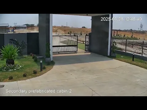
Images Captured by a Security Camera Show, for the First Time, the Right Lateral Slip on an Active Fault. See the Video That Could Redefine Seismic Studies.
The ground literally splits in half as a camera records everything. A road, a fence, and suddenly the landscape slides like drifting floating ice.
An unprecedented phenomenon has been documented in Myanmar: for the first time in history, a security camera has allegedly captured the exact moment a tectonic fault ruptures during an earthquake, showing how the ground literally divides in half.
On March 28, 2025, a devastating earthquake with a magnitude of 7.7 shook Southeast Asia, with its epicenter near Mandalay, the second-largest city in Myanmar. The security camera that documented this extraordinary event was installed at the Green Power Energy solar project in Tha Pyay Wa, capturing with unprecedented clarity the precise moment a fault ruptures at the surface during a major quake.
-
A Tiny Belgian Village Factory Produces Nearly 80% of the World’s Billiard Balls Using a Secret Resin for Decades-Long Durability

-
Glacier Express: The World’s Slowest Train Offers Spectacular Views of the Swiss Alps, Crossing 291 Bridges and 91 Tunnels Over 219 km

-
Asian fruit related to lychee gains popularity on a São Paulo farm, attracting attention for its sweet taste and unique appearance, turning a little-known crop in Brazil into a distinctive rural investment.
-
Brazilian Company Known for Brooms Grew for 95 Years to Become One of Latin America’s Largest Brush Manufacturers, with Over 300,000 Sales Points and Revenue of $150 Million


Viral Video Shows Surface Rupture in Real Time
The video, which went viral after being initially shared on Facebook and then on Reddit, begins with seemingly calm scenes: an entrance road, a security fence, and dusty hills on the horizon. Everything seems normal until a nearly imperceptible tremor occurs. The fence starts to vibrate gently, like a foreboding of what is to come.
In a matter of seconds, the scene transforms completely. The fence disconnects from its mechanism, the pavement of the road cracks, and before the astonished eyes of viewers, the right side of the landscape slides several meters, as if it were a giant floating ice slab. It is the very ground splitting — a geological process that usually occurs hidden beneath the surface and which, for the first time, has been documented with extraordinary clarity.
Geophysics Experts Highlight Unique Scientific Value
“As far as I know, this is the best video we have of a surface rupture during a major earthquake”, stated Rick Aster, a geophysicist at Colorado State University, to Live Science, suggesting that this footage could be the subject of future academic studies. His colleague John Vidale, from the University of Southern California, agrees: they have never seen a recording that clearly and in detail shows how the Earth’s crust ruptures to the surface.
The earthquake occurred along the Sagaing Fault, a significant tectonic fracture that runs through Myanmar from north to south. This fault is similar to the famous San Andreas Fault in California: both are strike-slip faults where tectonic plates move horizontally alongside one another. According to Aster, the movement observed in the video extends from the surface to a depth of between 20 and 30 kilometers.
As reported by EarthSky, the video clearly shows an example of right lateral slip: the right side of the ground shifts beyond the other, confirming the nature of the Sagaing Fault as a meeting point between the Indian Plate and the Sunda Plate.
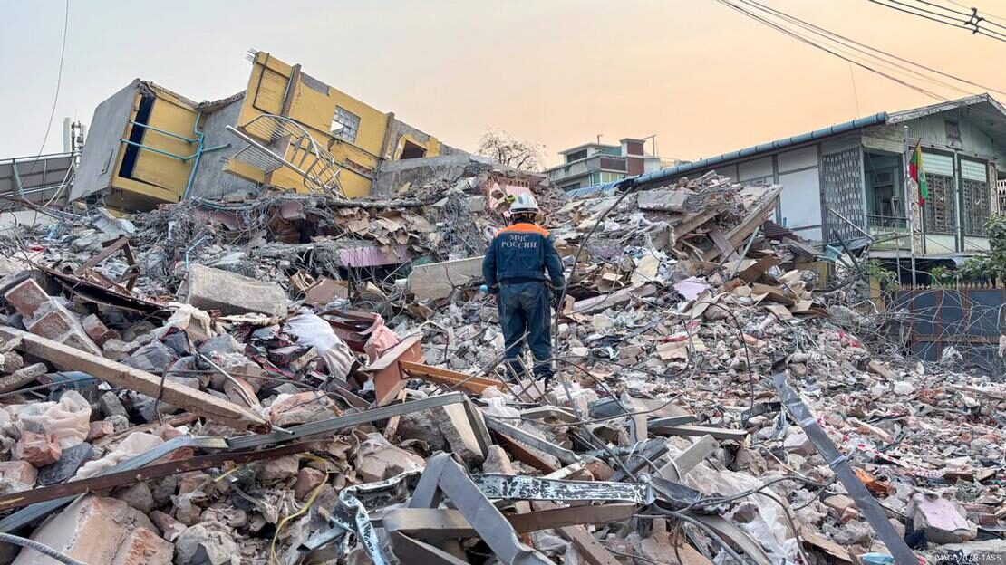
Humanitarian Crisis in Myanmar Following the Seismic Disaster
In addition to the geological spectacle, the human tragedy was devastating. According to the latest estimates from the UN, more than 3,800 people lost their lives, and thousands were injured. The catastrophe struck a country already facing an extremely complex situation, with a military dictatorship in power and an ongoing civil war.
The crisis is not over: with the monsoon season approaching, the UN warns that affected communities now face the additional risk of landslides and flooding, which could further exacerbate the humanitarian situation in the region.
Now, researchers hope to utilize this footage to better understand the dynamics of surface faults. Aster has no doubts: if it is possible to specify the details of location and context, the video will likely be the subject of scientific publications.


