
 Portuguese
  Spanish
Hidden beneath the Bahian backlands, Toca da Boa Vista gathers extensive galleries, preserved fossils, and rare geological formations in an underground system associated with Brazil’s natural history and research on large caves.
Toca da Boa Vista, in Campo Formoso, in northern Bahia, is the largest known cave in Brazil and South America, with 114 kilometers of mapped galleries as of 2020, according to the Geological Service of Brazil.
Beneath the caatinga, the underground system is distributed in a dry and labyrinthine network, formed by corridors, halls, fossils, and features associated with rare geological processes described in studies about the cavity.
Located in an arid landscape area, near the district of Laje dos Negros, the cave houses an extensive natural structure underground, whose dimension is not perceptible from the surface.
-
12-Year-Old Discovers 80-Million-Year-Old Marine Tylosaurus Fossil During Kansas Field Trip

-
At 24, Beatriz Becomes First Woman from Mato Grosso to Work on Live Power Lines with Energisa, Starting as a Meter Reader in 2022
-
Metal Detectorist Uncovers Up to 15,000 Roman Coins in Wales, Potentially the Largest Find of Its Kind in the Country

-
Top U.S. Bank Executive Fired After Dumping Trash on Street, Taking Bin Home, and Receiving Two Fines


The Geological Service of Brazil classifies the set formed by Toca da Boa Vista and the neighboring Toca da Barriguda as a geosite of international relevance, with scientific value linked to speleology, paleontology, and the reconstruction of ancient natural environments.
Toca da Boa Vista forms an underground labyrinth beneath the caatinga
The comparison with an underground city is used to gauge the scale of Toca da Boa Vista, but the main technical data lies in the extent mapped by the Geological Service of Brazil.
There are 114 kilometers already mapped in a single system, a distance greater than that separating many Brazilian municipalities and difficult to gauge for those observing only the external landscape of Campo Formoso.
Unlike a cave with a linear path and few halls, the cavity is organized like a dry labyrinth, with galleries branching out and changing direction in various internal sectors.
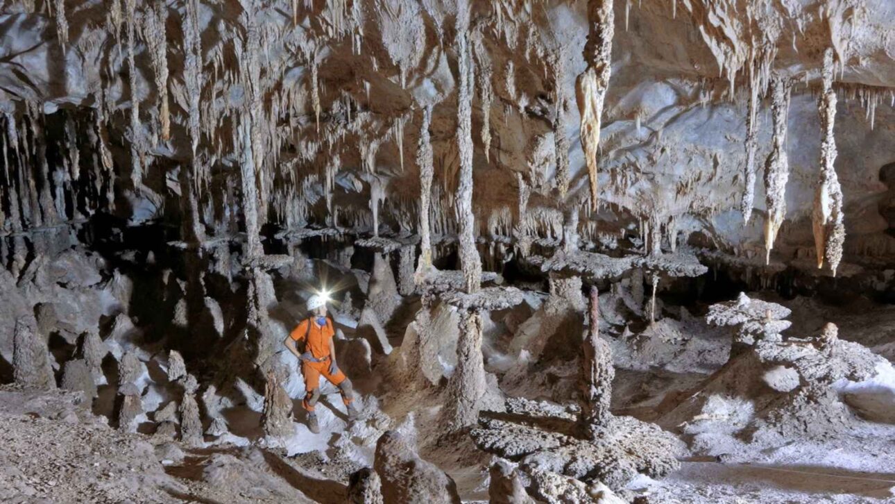
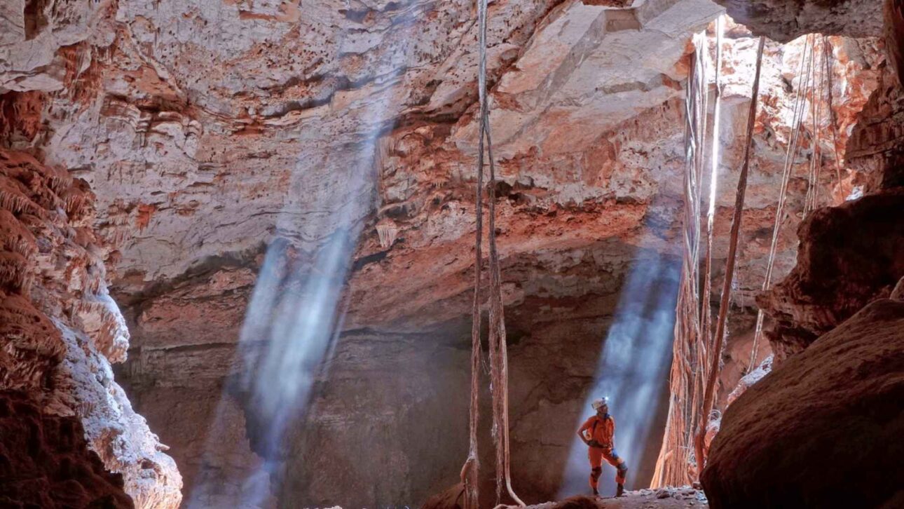
In several sections, narrow conduits alternate with wider spaces, a characteristic that requires technical exploration, specialized topography, and orientation procedures compatible with large underground systems.
According to the Geological Service of Brazil, the morphology of Toca da Boa Vista is complex and features conduits associated with folds and layers of dolomite in an approximately horizontal plane.
This configuration makes the cavity a reference in research for studies on large karst systems, especially in underground formations developed in carbonate rocks.
The main entrance is about 11 kilometers from Laje dos Negros, accessible via an unpaved road and a final stretch covered by trail.
Despite the relatively defined access to the entrance, internal circulation requires preparation, as the difficulty increases as the galleries advance to areas further from the starting point.
Rare fossils enhance the scientific importance of the cave
The relevance of Toca da Boa Vista is not limited to the extent of the galleries, according to the Geological Service of Brazil.
The cavity is identified by the agency as one of the main speleological and paleontological sites in the country, with fossil records used in studies on environmental changes that occurred in the Northeast during the Quaternary.
Among the materials already associated with the cave are preserved skeletons of extinct species, as well as records related to ancient fauna that occupied the region in periods prior to the current landscape.
The geosite’s registry mentions fossils linked to extinct primates, such as Cartelles coimbrafilhoi and Caipora bambuiorum, considered relevant for research on fossil vertebrates in Brazil.
Preserved in the underground environment, these materials serve as natural records of times prior to the current occupation of the area by human communities and typical caatinga vegetation formations.
In caves with these characteristics, the stability of certain internal sectors can contribute to the conservation of skeletons and sediments, allowing analyses on fauna, climate, and environmental transformations.
Radiometric datings conducted on secondary carbonates and fossil skeletons were also used in the reconstruction of episodes of climate change in the region.
According to the Geological Service of Brazil, the data indicate periods of greater humidity in the last 210 thousand years, when more forested environments occurred in areas now associated with the caatinga.
Hypogenic formation differentiates the underground system
The development form of Toca da Boa Vista is another element highlighted by the Geological Service of Brazil in the technical descriptions of the cavity.
Morphological, structural, hydrochemical, and isotopic evidence indicates that the dissolution of dolomites occurred through hypogenic processes, without direct relation to water coming from the surface.
In geology, hypogenic processes involve the action of fluids at depth, unlike formations primarily associated with rainwater infiltration from the soil.
This dynamic helps explain the distribution of the galleries and differentiates Toca da Boa Vista from caves formed by more frequent mechanisms in traditional karst areas.
The cave is associated with dolomitic carbonates of the Salitre Formation, in the geological context of the São Francisco craton.
Combined with structural controls and the circulation of underground fluids, this rock base produced a wide and dry system, with features analyzed in national and international research on carbonate caves.
During explorations, different internal sections received informal names used by researchers and speleologists, such as “Classic Boa Vista,” “New World,” “Third World,” “End of the World,” and “I-World.”
These names help in identifying sectors with their own characteristics and in orientation within a cavity where navigation depends on technical knowledge and detailed mapping.
Toca da Barriguda reinforces Bahia’s geological relevance
Near Toca da Boa Vista, the Toca da Barriguda is considered the second longest cave in Brazil, with 35 kilometers mapped according to the Geological Service of Brazil.
The two cavities are distinct and have no known physical connection, but are separated by about 700 meters and present similar geological characteristics.
The proximity between the two systems contributes to the scientific importance of the Campo Formoso region in the study of large Brazilian caves.
Besides the size of the cavities, the area gathers geological, paleontological, paleoenvironmental, and educational value, factors that reinforce the need for continuous research and conservation measures compatible with the fragility of the environment.
Toca da Barriguda also gathers large halls, fossil remains, and environmental records considered relevant in technical surveys about the geosite.
Even so, Toca da Boa Vista maintains a prominent position due to its mapped extension, the complexity of its internal labyrinth, and its role in research on hypogenic caves in ancient carbonate rocks.
Conservation of Brazil’s largest cave requires access control
The size of Toca da Boa Vista does not make it a conventional tourist attraction, as indicated by the technical descriptions of the cavity.
The Brazilian Geological Service’s registry indicates that unregulated visitation, even if sporadic, represents the main source of potential impact, with occasional records of degradation in areas accessed without control.
The complexity of the galleries, the internal temperature that can reach 29°C, and the almost absence of water make exploration more difficult, especially in sectors far from the main entrance.
For this reason, the environment requires the action of prepared teams, technical mapping, and care to avoid damage to formations, sediments, and fossil records preserved inside the cavity.
Initiatives to mark internal trails have been adopted to organize circulation and reduce impacts in visited sections of Toca da Boa Vista.
This measure helps protect sensitive sectors, but the proper management of the natural heritage depends on access control, specialized research, and recognition of the scientific importance of the underground system.
Under the Bahian hinterland, Brazil’s largest cave reveals a little visible dimension of the national territory.
The dry surface landscape contrasts with an underground network that preserves fossils, signs of ancient climates, and clues about geological processes responsible for the formation of a natural labyrinth of continental scale.


