Portuguese
  Spanish
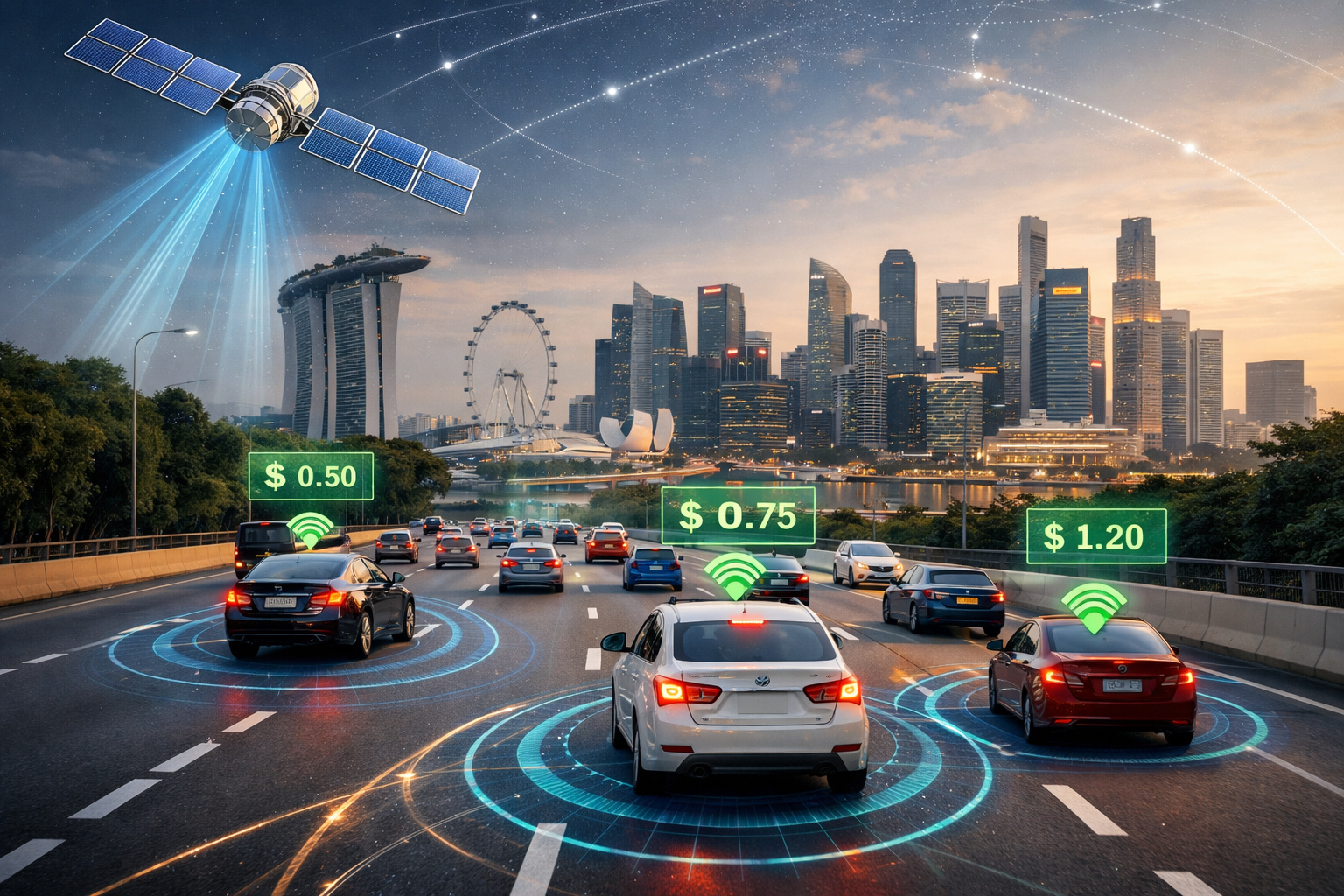
Singapore implements satellite toll that eliminates gantries and charges drivers based on real-time geolocation, transforming urban traffic.
In 2025, Singapore initiated one of the largest transformations ever made in urban mobility management worldwide by replacing its traditional electronic toll system with a new satellite-based architecture. The project, led by the Land Transport Authority, marks the transition from the classic model of physical gantries to a digital system known as ERP 2.0 (Electronic Road Pricing 2.0).
The change is not only technological but structural. For the first time, the toll collection no longer depends on visible fixed points and begins to operate through continuous geolocation. This means that drivers can be charged not only when passing a specific point but based on their real-time position within the city, creating a concept that experts are already describing as “invisible toll.”
According to official information from the transport authority, the new system began to be gradually implemented starting in 2023 and continues to expand until the complete replacement of the previous model. The transition includes the mandatory installation of an onboard unit in vehicles, capable of communicating with satellites and terrestrial networks.
-
2027 Toyota Corolla Cross Unveiled: New Design, Enhanced Fuel Efficiency, Reduced Maintenance Costs, Advanced Technology, Connected Services, and Up to 10-Year Warranty

-
Fiat Cronos Precision 2018: Affordable Sedan with Spacious Trunk and Reliable Maintenance
-
Volkswagen to Cut Production by 1 Million Cars by 2030, Reducing Jobs and Platforms, Focusing on More Profitable Models

-
Toyota Launches First 100% Electric Car in Brazil: bZ4X with 343 HP, All-Wheel Drive, 361 km Range, Priced at $419,990 BRL, Limited to 99 Units


ERP 2.0 how the satellite toll that eliminates gantries works
The new ERP 2.0 system uses GNSS (Global Navigation Satellite System) technology to track the position of vehicles with high precision. Each car receives an onboard unit that records movements and interacts with the central system. Unlike the previous model, where charges occurred only when passing physical gantries, ERP 2.0 allows for a much more flexible logic.
The charges can be applied by segment, by zone, by time, or even by distance traveled, depending on the policy defined by the authorities. This paves the way for a dynamic model, where rates can vary in real-time according to the level of congestion.
End of physical gantries completely changes the logic of traffic
Singapore has been a pioneer in the use of electronic tolls since the 1990s, with gantries strategically distributed throughout the city. With ERP 2.0, these gantries are no longer necessary. Monitoring and charging now occur digitally, without visible infrastructure on the road.
This transforms urban space and eliminates physical limitations, allowing for toll collection to expand to areas where it was previously not feasible to install structures.
Every kilometer could become a charge in the future of the system
One of the most relevant changes is the possibility of charging based on the distance traveled. Although the system is still in a transition phase, the technology already allows for this type of application.
This means that the model can evolve into a scenario where each kilometer traveled in certain areas has an associated cost.
Traffic is no longer regulated only by access to specific points and is monitored throughout the entire route, creating an unprecedented level of control.
Penalties continue to exist even without visible gantries
Despite the absence of physical structures, the system maintains penalty mechanisms. Drivers who do not have the mandatory onboard unit, who attempt to circumvent the system, or who do not pay the charges are subject to administrative and financial sanctions.
For foreign vehicles, for example, there are already specific rules that include mandatory daily charges if the vehicle is not equipped with the appropriate system. Enforcement is no longer visible, but remains active and integrated with government databases, allowing for the application of penalties even without direct intervention.
System allows dynamic tariffs and real-time control
One of the main objectives of ERP 2.0 is to enable more efficient traffic management. With real-time data, the government can adjust tariffs to reduce congestion during peak hours or in specific areas.
This creates an adaptive system, where the cost of driving can vary throughout the day. The driver begins to make decisions based on price, not just time, altering routes and schedules to avoid higher charges.
Singapore was already a global reference and now redefines the model
Even before ERP 2.0, Singapore was already considered one of the most advanced cities in the world in traffic management. The new system reinforces this position by introducing a model that other countries are just beginning to study.
The city becomes a real laboratory for smart mobility, where technology, economy, and urban planning integrate directly.
Impacts on behavior and urban planning
The introduction of such a sophisticated system has direct effects on driver behavior. With greater cost predictability and constant monitoring, there is an incentive to reduce car use under certain conditions. This also influences long-term decisions, such as housing choices, public transport use, and travel planning.
Like any geolocation-based system, ERP 2.0 raises discussions about privacy. Although authorities claim that the data is protected and used only for mobility purposes, the fact that the system records movements in real-time generates debates.
The same technology that improves traffic also enhances the capacity to monitor individual behavior, which requires regulation and transparency.
A new global model of urban mobility is beginning to emerge
The satellite toll in Singapore represents a paradigm shift. It shows that the future of traffic may lie in the combination of geolocation, real-time data, and dynamic pricing. Mobility ceases to be just movement and becomes a digitally managed service, with costs adjusted according to usage and impact.
Do you believe that the future of traffic will be based on charging per kilometer and real-time monitoring? Leave your opinion in the comments.