Portuguese
  Spanish
While Southern Brazil was preparing for the arrival of the most intense polar air of 2026, a wave of storms hit Paraná between Saturday, May 16, and Sunday, May 17, with winds over 60 km/h, heavy hail, and widespread damage to at least 200 homes in Ponta Grossa, according to a report by meteorologist Estael Sias published by MetSul.
The instability line combined 3 dangerous meteorological factors. A low-pressure center mixed with warm surface air and the advance of a cold front associated with a polar air mass.
The clash between the 3 masses created severe convective storms.
-
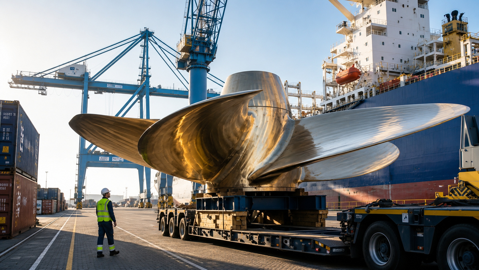
131-Ton Naval Propeller, Costing Up to $4 Million and Taking 4 Months to Manufacture, Powers the World’s Largest Cargo Ships Almost Invisibly

-
Brazil’s Maceió Port Joins Decarbonization Efforts with Study to Supply Clean Energy to Cruise Ships

-
Brazilian Port Expands Ship Capacity to 9.5 Meters, Boosting Cargo Transport and Reducing Logistics Costs
-
New Smart Radar Begins Issuing Fines to Solo Drivers in Carpool Lanes, Uses Cameras to Count Occupants, Changing Traffic Enforcement Rules on Busy European Roads


The result was a trail of destruction in 4 cities. Ponta Grossa, Porto Rico, Dourados, and Coronel Sapucaia reported roofs torn off, fallen trees, downed poles, broken windshields, and blackouts in entire neighborhoods, according to the state Civil Defense.
What happened in Ponta Grossa and Porto Rico
The city of Ponta Grossa, in the south-central region of Paraná, was the hardest hit. According to the municipal Civil Defense, about 200 homes suffered structural damage on Saturday, with at least 1,000 people directly affected.
According to MetSul, the winds were accompanied by intense rain, hail, and lightning. The facade of a steakhouse collapsed in the city center.
Structures of an outdoor event were destroyed in half an hour.
In Porto Rico, in the northwest of Paraná, on the banks of the Paraná River, similar winds knocked down trees onto the power grid and cut off electricity in 7 neighborhoods for more than 14 hours.
Copel mobilized 12 emergency teams.
Meanwhile, the event also spread to Mato Grosso do Sul. In Dourados, winds over 60 km/h were recorded.
In Coronel Sapucaia, on the border with Paraguay, Civil Defense counted 38 properties with roofs partially or completely torn off.
The numbers that separate severe storms from common ones
The force of the winds placed the event in the “gale” category according to the classification of the National Institute of Meteorology (INMET). The official criterion considers a gale to be sustained winds above 50 km/h.
According to INMET, winds from 60 to 90 km/h are typically categorized as “severe,” capable of knocking down fragile trees and tearing off zinc roofs.
Above 90 km/h, they reach the level of a “cyclonic storm” and can knock down older masonry structures.
Paraná recorded on May 17 gusts of up to 80 km/h at least in 4 automatic stations. The state’s average in the autumn months ranges between 12 and 18 km/h, according to a 25-year INMET history.
Meanwhile, the hail on the TORRO classification scale reached levels H2 and H3 in Ponta Grossa. These codes correspond to stones 1 to 3 cm in diameter, enough to tear off tiles and break windshields of parked vehicles.

Technical reveal: why 3 air masses created chaos
In the background, meteorology explains the event as a “mesoscale convective system” (MCS). It forms when 3 different air masses collide at high speed in the atmosphere.
According to MetSul’s technical details, on Saturday, May 16, a cold front began to advance from Rio Grande do Sul. At the same time, warm and humid air from the Amazon basin was pushing from the North.
And an Antarctic polar air mass was preparing to descend from Patagonia.
The clash created a vertical instability layer 12 km high. When the warm air rose rapidly, it condensed into “supercell” cumulonimbus clouds.
These clouds are responsible for more than 80% of hail and tornado cases in Brazil.
Meanwhile, the low-pressure center acts as a trigger. It reduces local atmospheric pressure by up to 18 mbar below the average of 1,013 mbar. This relative vacuum accelerates horizontal wind near the surface.
How Paraná’s Civil Defense responded
The institutional response mobilized 5 agencies in parallel. The state Civil Defense coordinated municipalities, the Fire Department, Copel, Sanepar, and the 2nd Military Police Battalion.
According to Paraná Civil Defense, 14 red alerts were issued via SMS on Saturday night to registered cell phones in the system.
The alert covered 36 municipalities in the south-central and northwest regions of the state.
The response schedule followed protocol. Within 4 hours after the event’s peak, teams began damage assessments. Within 24 hours, temporary covering material, tarps, and tiles were delivered to 23 families.
The initial direct cost is estimated at R$ 1.2 million by the state Civil Defense.
Above all, the state is preparing a request for federal emergency recognition to the Ministry of Integration and Regional Development. The process usually takes 7 to 14 days to release federal resources between R$ 5 and R$ 25 million depending on the impact.

Human reveal: meteorologist Estael Sias and the early warning
The human face of the preventive work is meteorologist Estael Sias from MetSul. She issued the first alert for the event on Thursday, May 14, 48 hours before the convective system reached Paraná.
According to MetSul’s history, Sias has been working in severity forecasting for 22 years. She coordinates the issuance of alerts for public agencies in Southern Brazil in partnership with the Civil Defense of the 3 states.
The meteorology company was founded in Porto Alegre in 1992 and covers the Southern Cone.
Meanwhile, the early forecast allowed municipalities to reinforce 4 measures. Preventive suspension of classes in 11 municipalities, mobilization of 320 Civil Defense agents, readiness of 18 health units, and opening of 6 temporary shelters.
On the other hand, the official SMS alert system of state governments still has uneven coverage in Brazil. In São Paulo, adherence reaches 78% of the urban population.
In Paraná, it is 54%. In Northern states, it is below 30%.
How the event connects with the polar air of May 19-20
The convective system on the 17th acted as a prologue to the polar air mass that arrived on May 19-20.
According to MetSul, it is a classic pattern: severe storms precede the entry of cold air by 36 to 72 hours.
According to MetSul, Rio Grande do Sul recorded on May 19 and 20 minimums close to -5 °C in Bagé, São José dos Ausentes, and Vacaria.
São Paulo capital had the coldest afternoon of the year on May 19.
Meanwhile, the meteorological sequence does not end there. According to MetSul’s analysis, a second polar corridor is expected to advance between May 25 and 30.
Temperatures in the South may return to levels comparable to the May 19-20 event.
Above all, the pattern of severe storms followed by cold air tends to repeat 3 to 5 times between May and August.
Autumn and early winter are more turbulent climate transition periods in Southern Brazil.

Future reveal: the next climate window until June
The next step predicted by MetSul is the monitoring of 2 new cold fronts until the end of May 2026.
The first is expected to cross the South between May 25 and 27. The second arrives in the first week of June.
Meanwhile, Paraná’s Civil Defense is preparing a contingency plan for winter. The goal is to reduce the average response time to the homeless by 30%, currently at 7 hours in the state.
The fleet of vehicles and the stock of tarps and tiles will be doubled.
According to Anac and INMET bulletins, the 4 capitals of the South (Curitiba, Porto Alegre, Florianópolis, and São Paulo) are expected to record at least 8 days with frost in the winter of 2026.
It is worth remembering the coverage of other relevant operational fronts in the Brazilian mobility sector.
- Event date: May 16-17, 2026 (Saturday night to Sunday)
- Affected cities in PR: Ponta Grossa, Porto Rico
- Also in MS: Dourados, Coronel Sapucaia
- Wind speed: over 60 km/h (up to 80 km/h in gusts)
- Affected homes: about 200 in Ponta Grossa
- People affected: approximately 1,000
- Origin: mesoscale convective system (3 air masses)
- Initial direct cost: R$ 1.2 million (Civil Defense PR)

The points that still depend on reconstruction
Despite the early warning, 3 fronts still depend on sustained response. The reconstruction of roofs in the 200 homes in Ponta Grossa is expected to take between 30 and 60 days.
On the other hand, the request for federal emergency recognition needs to be approved by the Ministry of Integration. The result determines the pace of releasing up to R$ 25 million in federal resources.
Finally, the SMS alert system needs to expand coverage in Paraná, currently at 54% of the urban population.