


LiDAR Technology exposes pre-Hispanic remains under the Chocó Andino forest and expands the archaeological record in a region of difficult access, marked by biodiversity, rugged terrain, and ancient occupations still little documented.
An archaeological investigation conducted with LiDAR technology identified more than 200 mounds, over 100 terraces, and ancient roads under the dense vegetation of the Chocó Andino, northwest of Quito, Ecuador.
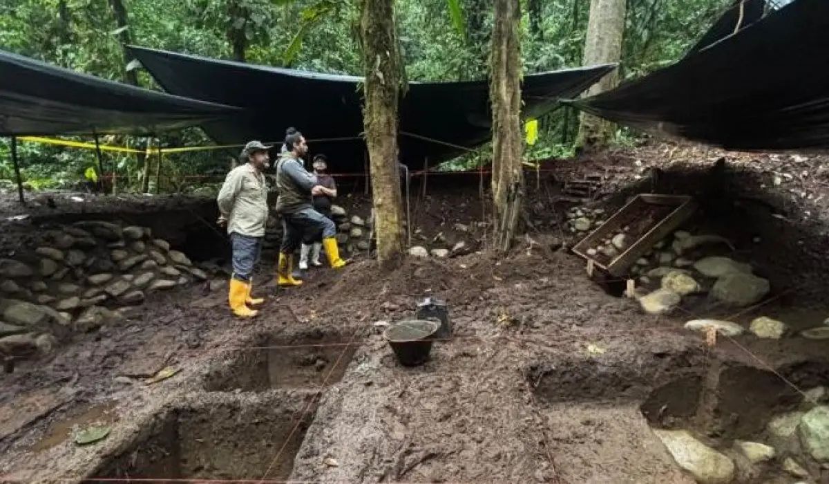
The survey was conducted in December 2025 by the Metropolitan Institute of Heritage (IMP), in the community of San Francisco de Pachijal, in the parish of Pacto.
The data expands the known record of pre-Hispanic structures in an area of approximately 600 hectares.
-
Fossils millions of years old reveal that giant capybaras once dominated Chile, a country where the largest rodent on the planet simply no longer exists today.

-
Former coal mining area in the central United States receives nearly 17,000 solar panels generating 9.8 megawatts, serving over 650 subscribers and including about 200 low-income families without installing anything on rooftops.

-
Hidden beneath a small entrance in Namibia’s underground, the largest underground lake in the world is the size of 2 football fields, 264 meters deep, and even has rare animals that survive without sunlight.

-
The industry relies on oil to manufacture plastic, but a 16-year-old girl used banana peels and managed to create a bioplastic after two years of attempts.


Before the use of the technology, the area was described as a smaller set, consisting of about 40 mounds and 10 terraces.
Remote sensing of the terrain, however, revealed a broader distribution of constructions covered by the forest.
The research was developed to document and protect the cultural heritage of the Chocó Andino, a region marked by rugged terrain, dense vegetation, and high biodiversity.
These characteristics hinder traditional archaeological surveys and help explain why part of the structures remained without detailed records for so long.
LiDAR Technology revealed structures under the forest
LiDAR, an acronym for Light Detection and Ranging, uses laser pulses to penetrate the tree canopy and generate precise maps of the ground surface.
The technique allows identifying changes in the terrain even in areas covered by dense forest, without relying solely on direct field observation.
In the case of San Francisco de Pachijal, the technology recorded mounds, terraces, and ancient paths distributed throughout the analyzed area.
Circular and rectangular structures were also identified, along with connections between different points in the landscape.
According to archaeologist Juan Jijón, consultant for the IMP, these marks indicate deliberate human modification of the environment.
The presence of geometric shapes and connecting roads suggests a territorial organization associated with productive, social, and ceremonial activities.
The analysis still depends on the continuation of studies, but the data already allows the IMP to treat the region as a pre-Hispanic cultural landscape.
This interpretation is based on the number of structures found, the relationship between them, and the way they appear integrated into the terrain.
Studied area is small compared to the Andean Chocó
The mapped area corresponds to about 600 hectares.
The Andean Chocó, in turn, occupies more than 280,000 hectares, according to the data cited in the survey.
Therefore, researchers believe that new structures may be identified if the investigation is expanded to other areas of the region.
This proportion is relevant to gauge the reach of the finding without turning the hypothesis into a definitive conclusion.
The survey confirms the existence of an extensive archaeological area within the analyzed sector, but it does not yet allow us to state what the total size of the undocumented pre-Hispanic occupation is.
The formulation adopted by the researchers is one of caution.
The material found indicates a more complex landscape than previously known, but the real extent, precise chronology, and limits of this occupation still need to be defined by new research stages.
Even so, the number of mounds and terraces located in a fraction of the territory reinforces the need for heritage protection.
According to the IMP, one of the project’s objectives is to strengthen the heritage management of Quito and prevent the loss of archaeological evidence in hard-to-reach areas.
Structure near the San Francisco River was compared to Tulipe
During the fieldwork, archaeologists also recorded a sunken rectangular structure near the San Francisco River.
According to the project’s description, the construction shows similarities with architectural elements found in the Tulipe Archaeological Complex, located in the regions of Gualea and Nanegalito.
The comparison with Tulipe was cited by researchers because of the formal characteristics of the structure and its relationship with hydraulic knowledge.
The original text points out that this type of vestige may indicate technical mastery in water management by the populations that occupied the area.
Without an absolute dating published, it is not possible to precisely define the construction period of the structure.
The association with the Yumbo culture was made based on the material culture related to the site and the existing knowledge about the pre-Hispanic occupation of the Andean northwest.
The Yumbos are mentioned by experts as a pre-Hispanic society associated with this region of Ecuador.
In the original text, the remains are attributed to this group, but detailed confirmation about chronology, function of the structures, and phases of occupation depends on complementary archaeological analyses.
Archaeological heritage of Quito enters the focus of research
For the IMP, the investigation has a scientific and heritage purpose.
Archaeologist Dayuma Guayasamín stated that the objective is to protect the sites, understand how cultural landscapes were formed, and strengthen Quito’s heritage.
The statement places the survey within a preservation policy.
In areas like the Andean Chocó, where the forest hinders access and visualization of the structures, the use of mapping technology can help guide measures for recording, research, and conservation.
The protection of these remains also depends on more detailed information about location, state of conservation, and risk of impact.
For this reason, identifying the structures is just one step in the process, which still requires technical interpretation and territorial management actions.
The survey shows that the Andean Chocó forest preserves marks of human occupation prior to Spanish colonization.
According to the archaeologists involved, reading these marks can help understand how pre-Hispanic societies organized space, circulated through the region, and used areas near rivers and slopes.
Dating and total extent still depend on new analyses
The investigation released by the IMP presents numbers on the mapped area and the main types of structures identified, but does not provide all the necessary data for a complete interpretation of the site.
The exact date of the constructions, the time of occupation, and the total extent of the archaeological landscape have not yet been confirmed with certainty in the available material.
There are also not enough details in the original text about the complete analysis methodology, the materials found in the field, or the technical criteria used to link all the remains to the Yumbo culture.
Therefore, the cultural attribution should be treated as the interpretation presented by the specialists, and not as a closed conclusion about each structure.
Based on the available data, the central point is that LiDAR technology has significantly expanded the knowledge about the pre-Hispanic presence in San Francisco de Pachijal.
What previously appeared as a smaller set of mounds and terraces has now been recorded as an area with hundreds of human modifications to the terrain.
For the reader, the main question left by the research is not only in the number of structures already identified, but in what future mapping stages may reveal in other parts of the Chocó Andino.


Be the first to react!