
 Portuguese
  Spanish
Small municipality in the interior of Mato Grosso occupies a rare landscape, marked by relief rings, deformed rocks, and traces of an ancient impact that made the Araguainha Dome a reference for geological studies in South America.
Araguainha, in Mato Grosso, is linked to one of the continent’s rarest geological formations, the Araguainha Dome, considered the largest known impact crater in South America, with about 40 kilometers in diameter.
Located on the border between Mato Grosso and Goiás, the structure originated from the collision of a celestial body with the Earth’s surface approximately 245 million years ago, near the boundary between the Permian and Triassic periods.
With 1,010 inhabitants in the 2022 Census and an estimated population of 997 people in 2025, the municipality occupies an area marked by relief rings, valleys, and rocks deformed by the impact.
-
Federal Police involved in the case to identify the person responsible for hacking the Civil Defense system, which sent ten false alerts, frightened residents of different capitals, and turned messages about real risks into notifications with “misanthropy” and even alien attacks.

-
Extreme drought causes ghost village to reappear at the bottom of the reservoir that supplies Athens, revealing houses, a school, and ruins swallowed since the 1980s as the lake shrinks and exposes the water crisis threatening the capital of Greece.

-
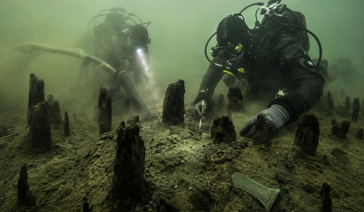
An entire village lay asleep at the bottom of a lake for 3,000 years: divers suction sediments in Italy and reveal more than 600 wooden stakes, bronze tools, and traces of a Bronze Age settlement hidden underwater.
-
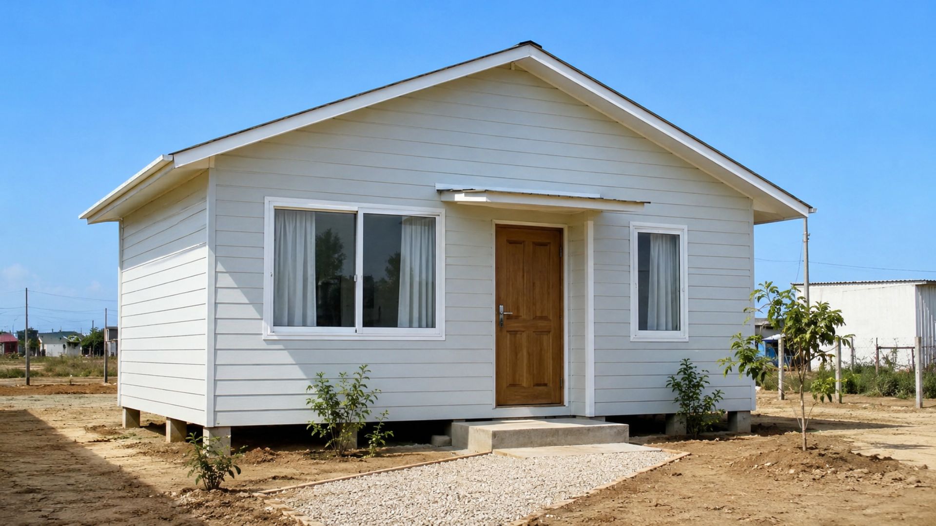
They call it the “Shopee house” and even cardboard, but the R$ 20,000 house is a certified Wood Frame from Alea, financed by Minha Casa Minha Vida: understand if it’s worth more than masonry.


Now partially eroded, the landscape still preserves geological signs studied for decades by Brazilian and foreign researchers, who analyze the marks left by a rare event in the continent’s natural history.
Largest impact crater in South America
Although popularly called a crater, the Araguainha Dome does not appear as an open cavity visible in its entirety, as the structure has been modified by erosion, sedimentation, and other natural processes.
In geology, ancient formations of this type are called astroblemes, a term used to identify impact marks that have partially survived after millions of years of transformations on the Earth’s surface.
The formation was born from the collision of a celestial body in an area that, according to geological studies, was likely covered by a shallow marine platform before environmental changes altered the region.
With the force of the impact, sedimentary rocks of the Paraná Basin and parts of the crystalline basement were affected, deforming deep layers and bringing older materials to the surface.
At the center of the structure, the impact produced a raised core, a common phenomenon in complex craters and responsible for exposing pre-Devonian granite in an area of approximately 6.5 kilometers in diameter.
Around this core, sedimentary units appear distributed in rings, composing a relief formed by annular depressions, valleys, arcs of hills, and steep terraces that help reveal the impact’s dimension.
In some sections, sandstone layers of the Furnas Formation appear inclined at very steep angles, forming elevations that reach about 150 meters above the surrounding areas.
Location of the Araguainha Dome
Between the localities of Araguainha and Ponte Branca, in Mato Grosso, lies the approximate center of the Araguainha Dome, at coordinates 16º47’S and 52º59’W.
The Araguaia River cuts through the structure and separates portions located in Mato Grosso and Goiás, showing that the formation exceeds the administrative boundaries of the municipality that gives it its name.
Even though it is mainly associated with Araguainha, the dome spreads over a wider area, and studies on the geopark proposal indicate that about 40% of the structure is in Goiás.
Before being recognized as the result of a celestial body impact, the circular relief was interpreted as a product of Earth’s internal processes, including hypotheses related to intrusions and volcanic activity.
The impact origin theory gained strength from the works of Robert Dietz and Bevan French in 1973, and was later reinforced by research conducted by Alvaro Crósta and other scholars.
Among the evidence considered decisive are shock metamorphism features, impact breccias, and lamellae in quartz crystals, records that do not usually appear in common geological processes.
Evidence of the impact on the rocks
The most important evidence of the collision is not only in the circular shape seen in satellite images but also in the deformed rocks, altered minerals, and outcrops exposed by erosion.
The impact produced microscopic deformations in minerals, shatter cones, breccias, and planar features in quartz, feldspar, and mica, all linked to extreme pressures.
Since they form under conditions far exceeding the normal pressures of the Earth’s crust, these marks help geologists differentiate impact craters from structures caused by volcanism, erosion, or tectonic movements.
In the Araguainha Dome, the most relevant outcrops appear in the uplifted core and along road cuts, especially on the connection between Ponte Branca and Araguainha.
In these spots, the exposure of rocks allows observation of part of the sequence affected by the impact and subsequent erosion, providing important material for research on ancient impacts on Earth.
With an approximate area of 1,300 square kilometers, the complete structure does not easily impose itself on the view of those traveling through the municipality, but becomes more evident in aerial images and geological maps.
Relief of Araguainha and local life
Amid hills, valleys, and undulating surfaces, Araguainha developed over a landscape shaped by ancient geological processes, although urban routine also depends on historical, economic, and regional factors.
The presence of the dome helps explain the terrain configuration, but it does not solely summarize the occupation of the municipality, which maintains characteristics common to small towns in the interior of Mato Grosso.
With a reduced population and low population density, Araguainha records 1.50 inhabitants per square kilometer in the 2022 Census, an indicator that reinforces the sparsely populated profile of the municipal area.
In the local economy, rural activities and public services predominate, while scientific interest in the dome serves as an element of visibility in debates on geological conservation, education, and tourism potential.
In recent years, the formation has been cited in initiatives aimed at valuing geosites and creating a geopark, a proposal that seeks to protect areas of scientific interest.
This discussion involves preserving the landscape, expanding the educational use of the territory, and preventing unplanned interventions from compromising natural evidence associated with the impact that formed the Araguainha Dome.
Preservation of the Araguainha Dome
Preserving the Araguainha Dome is relevant because the structure contains records of a rare event in the continent’s geological history, in a scenario where many terrestrial craters have been destroyed or masked by erosion.
Each preserved astrobleme helps researchers reconstruct impact processes on Earth, especially when it retains visible evidence in rocks, landforms, and microscopic features associated with extreme pressures.
In the case of Araguainha, scientific interest increases due to its size, age, and the variety of available records, which include macroscopic and microscopic marks of shock metamorphism.
The conservation of outcrops, landforms, and areas of scientific access allows researchers to continue analyzing the origin of the structure and the changes that occurred after the impact.
Without proper planning, construction, slope cuts, and interventions on exposed rocks can damage important observation points, reducing the scientific value of a unique landscape on the continent.
At the same time, geological recognition does not automatically transform the region into a consolidated tourist destination, as qualified visitation depends on infrastructure, signage, environmental protection, educational actions, and continuous public management.
What science knows about the impact
The most cited studies place the formation of the Araguainha Dome around 245 million years ago, although promotional materials often round this age to about 250 million years.
This difference does not alter the overall classification of the event, but it is relevant for journalistic accuracy, especially because the date brings the impact closer to the boundary between the Permian and Triassic periods.
The final crater is about 40 kilometers in diameter, while geological estimates suggest that the transient crater, formed immediately after the impact, would have been smaller.
After the collision, the initial deepening was modified by collapse, central uplift, and long erosion processes, responsible for transforming the original feature into the landscape observed today.
The dome also stands out for being among the few known and studied impact structures in South America, where the number of confirmed craters is small.
In Brazilian territory, the formation occupies a prominent position due to its size, the exposure of deformed rocks, and the ability to reveal geological processes that occurred long before human occupation.
The current landscape of Araguainha, therefore, combines a small town, a continentally relevant geological structure, and preserved traces of an event that predates human history in the Brazilian Midwest by far.


Be the first to react!