Portuguese
  Spanish
The frequency of alerts in Santa Catarina is linked to climatic, geographical, and urban factors that explain the constant attention of the Civil Defense and help understand the impact of extreme events in the state.
In 2025, Santa Catarina concentrated 333 of the 805 natural disaster risk alerts issued in Brazil by the national severe warning system, equivalent to just over 41% of the total.
The data, released by Agência Brasil based on the Civil Defense alert service, places the state as the main destination for notifications in the country that year, ahead of São Paulo and Amazonas.
The number alone does not represent all disasters that occurred in Santa Catarina.
-
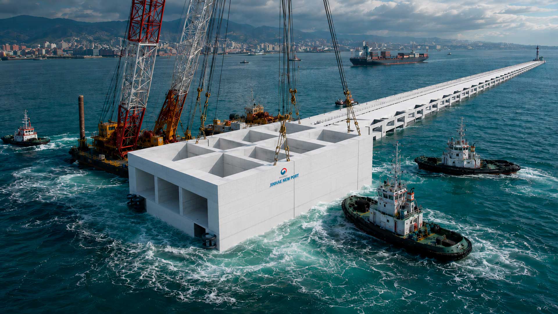
South Korea to Sink 20 Massive Concrete Coffers Off Busan Coast to Build 1.4 km Breakwater at Jinhae New Port, Part of $9.4 Billion Expansion to Rank Among World’s Top 3 Ports

-
Venice Deploys 78 Massive Steel Gates to Shield City from Extreme Adriatic Tides

-
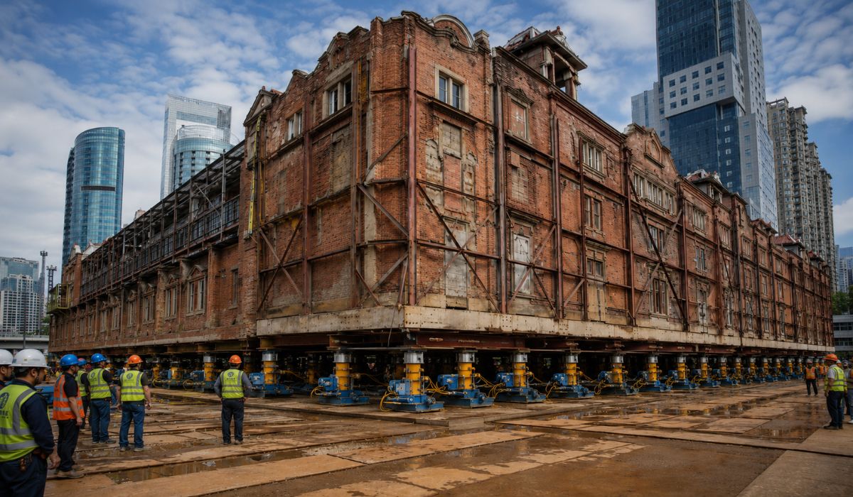
China Uses 432 Robots to Move a 7,500-Ton Historic Building in Shanghai, Preserving Architecture While Creating Space for Underground Center
-
World Cup Ball Chip Uses Technology to Detect Invisible Touches, Confirms Offside, Secures Portugal’s Victory Over Croatia


It indicates the number of alerts sent by the national system for severe or extreme risk situations, in a state whose geographical configuration, according to meteorologists and monitoring agencies, favors the occurrence of phenomena such as intense rains, gales, floods, flash floods, and landslides.
Why Santa Catarina concentrates so many alerts
Santa Catarina’s geographical position helps explain the frequency of adverse meteorological events.
The state is located in an atmospheric transition zone, where cold air masses coming from the South can meet warm, humid air from the Amazon and the Central-West.
When these systems meet, the atmosphere can become unstable and favor the formation of heavy clouds.
According to meteorologist Maria Laura Rodrigues, from Epagri/Ciram, both heatwaves associated with storms and cold waves, which can cause frosts and snow in higher areas, are common in the state.
“Both heatwaves, which cause storms with torrential rains, and cold waves, with frosts and even snow, are common,” states Maria Laura Rodrigues, meteorologist and area coordinator at Epagri/Ciram.
The meteorologist states that the clash between air masses with different characteristics forces the warm air to rise.
This process is associated with the formation of severe storms, with heavy rain, electrical discharges, hail, wind gusts, and, in specific situations, phenomena such as microbursts and tornadoes.
Santa Catarina’s relief also interferes with the distribution of rain and temperature.
Mountains near the coast favor the elevation of humid air and can intensify precipitation in certain areas, while valleys, plateaus, and slopes create local variations in temperature and humidity.
Extratropical cyclones in Southern Brazil
In addition to the meeting of air masses, Santa Catarina is influenced by extratropical cyclones, low-pressure systems common in mid-latitudes.
According to Epagri/Ciram, these phenomena form when warm and cold air masses meet and can cause rapid changes in weather and sea conditions.
When they intensify near the coast, cyclones can cause rain, strong winds, temperature drops, rough seas, and coastal surges.
Epagri/Ciram reports that gusts can exceed 60 km/h in coastal regions and southern Santa Catarina, posing a risk to navigation, fishermen, bathers, and coastal areas.
This set of factors does not turn all events into disasters, but it increases the need for constant monitoring.
In urbanized areas, intense rain can have a greater impact when it affects regions with nearby rivers, occupied slopes, insufficient drainage, or a history of flooding.
El Niño keeps attention on Santa Catarina’s climate
Climate projections also factor into the risk assessment.
Inmet reported, based on NOAA forecasts issued on April 20, 2026, that neutrality in the equatorial Pacific is expected to give way to an increased probability of El Niño formation throughout the year.
According to Inmet, the chance of the phenomenon establishing itself exceeds 60% starting from the May-June-July quarter and could reach 90% or more in the August-September-October quarter.
In Brazil, El Niño usually has different effects by region, and in the South, it can favor periods of above-average rainfall, depending on the intensity of the phenomenon and other atmospheric factors.
The forecast does not allow stating that there will be a disaster in a specific location.
The data serves as a reference for monitoring agencies because frequent or heavy rainfall events, when combined with waterlogged soil and high rivers, increase the risk of occurrences in vulnerable areas.
Natural disasters marked Santa Catarina’s history
The state’s exposure also appears in historical records.
The Tubarão flood, in March 1974, is described in a study by the Military Fire Department of Santa Catarina as the natural flood that caused the highest number of deaths in the state.
In March 2004, Hurricane Catarina hit southern Santa Catarina and northern Rio Grande do Sul.
The government of Santa Catarina describes the episode as a milestone in Brazilian meteorology, as it is the only hurricane officially recorded in the South Atlantic to date.
Four years later, the November 2008 rains caused floods and landslides in the Itajaí Valley and other areas of the state.
A report by the World Bank and CEPED/UFSC estimated the total costs of that event at R$ 4.75 billion, a value equivalent to about 2.67% of the state’s GDP at the time.
In 2023, Santa Catarina once again recorded a large volume of occurrences recognized by the federal government.
According to the Presidency’s Communication Secretariat, there were 281 recognitions of emergency situations or states of public calamity in 171 municipalities in Santa Catarina, mainly involving intense rains, hail, gales, drought, flash floods, and floods.
How Civil Defense alerts work
Communication with the population occurs through two main systems.
The first is the Civil Defense SMS, which requires prior registration and works without internet.
To receive alerts, citizens must send the ZIP code of the locality of interest to the number 40199 free of charge.
The second is Defesa Civil Alerta, based on Cell Broadcast technology.
In this case, the message appears directly on the screens of cell phones connected to 4G or 5G antennas within the risk area, without the need for registration, an app, or an internet connection.
The system works with two levels of severity.
The severe alert indicates a very high danger situation and advises the population to follow the recommendations sent; the extreme alert indicates an emergency with imminent risk to life and requires immediate action, according to Santa Catarina’s Civil Defense.
Santa Catarina leads adherence to Civil Defense SMS
Santa Catarina also appears at the top for proportional adherence to the SMS service.
According to data released by the state government in February 2026, 10.54% of Santa Catarina’s population was registered to receive early warnings or alerts of imminent risk, a rate higher than the national average of 5.18%.
Greater adherence to the system can expand the reach of preventive messages, but it does not eliminate the need for other forms of communication.
In situations of power outages, road blockages, signal failures, or displacement of residents, the actions of municipal civil defense, local radios, sirens, official social media, and field teams continue to be part of the response.

Climate monitoring was expanded in the state
The monitoring structure also underwent expansion.
In April 2026, Santa Catarina’s Civil Defense reported the completion of the hydrometeorological network expansion to 172 stations distributed throughout the state, with 130 new units added to 42 existing ones.
These stations measure variables such as river levels, rainfall volume, temperature, humidity, atmospheric pressure, wind direction, and speed.
According to the Civil Defense, data is updated every 15 seconds and used for real-time monitoring of meteorological and hydrological conditions.
The network assists in issuing alerts and the work of technical teams, especially in situations of intense rain, rapid river rises, and storms.
The state government informed that the project received an investment of R$ 9 million and provides for continuous maintenance of the equipment.
Climate change enters risk planning
The increase in global temperature has also become part of disaster risk planning.
The IPCC, a panel of scientists linked to the UN, points out that warming intensifies extreme precipitation events on a global scale, because a warmer atmosphere can retain more water vapor.
According to Maria Laura Rodrigues, periods of more significant warming in the Atlantic were accompanied by a trend of increasing intensity and frequency of extreme events in Santa Catarina.
She also states that a warmer atmosphere can make meteorological systems more intense and concentrate rain in shorter periods and smaller areas.
This scenario requires a regionalized reading of risks.
In the same state, excessive rain may occur in one area, drought in another, and a sharp drop in temperature in high-altitude regions, depending on the season, atmospheric circulation, and oceanic conditions.
The sequence of alerts shows that Santa Catarina combines natural and urban factors that require permanent monitoring.
With faster warning systems and a population more connected to official channels, the challenge for municipalities in Santa Catarina is to transform alerts into actions before the risk becomes an emergency.