Portuguese
  Spanish
An extratropical cyclone off the coast of Rio Grande do Sul brings heavy rain between Saturday (25) and Sunday (26) to Santa Catarina and Paraná, with temperatures in the mountains potentially reaching 0°C, highs of only 17°C in south-central Paraná, a low of 20°C in Florianópolis, and 18°C in Curitiba.
The last weekend of April brings a sudden change in weather for Southern Brazil, with intense rain and a sharp drop in temperature caused by the formation of an extratropical cyclone off the coast of Rio Grande do Sul between Saturday and Sunday (25 and 26). According to Meteored, the system takes shape between Friday night and Saturday morning (25), with a cold front already changing the weather in the region since the early hours of the day, and instability intensifies throughout the weekend with strong downpours and a risk of storms, especially in the Far West of Santa Catarina. In the mountainous areas, the rain is accompanied by temperatures that can approach 0°C, an early winter that surprises those who expected severe cold only in May.
The combination of the cyclone and cold front will progressively affect different regions. On Saturday morning, the weather will already be cloudier in Santa Catarina and southern Paraná, with weak and isolated precipitation in the Mid-West, Plateau, and Southern Coast of Santa Catarina. During the afternoon and evening, the rain intensifies and begins to affect the Greater West of SC and areas of western and southwestern Paraná. On Sunday (26), instability expands, with precipitation forecast throughout the day in Santa Catarina territory and a risk of storms advancing in the morning and evening also over the central region of Paraná.
Where the rain will be most intense during the weekend
The precipitation map shows that the rain will not be uniform. The Far West of Santa Catarina concentrates the highest risk of severe downpours on Sunday, while in Paraná the most critical scenario should develop between the west, southwest, and central region, where rain can reach moderate to strong intensity throughout the day. The coastal regions of both states will also receive precipitation, but with less intensity compared to the interior, a typical pattern for cyclonic systems that draw moisture from the ocean and discharge it mainly over continental areas.
-
Germany Opens World’s Largest Smart Power Semiconductor Factory with €5 Billion Investment, Creating 1,000 Jobs and Doubling Capacity for AI and Energy Needs

-
Kazakhstan’s Torysh Valley Holds Thousands of Giant Stone Spheres, Intriguing Scientists with Ancient Oceanic “Cannonballs”

-
Egypt Discovers 18 Ancient Tombs with Gold Tongues, Unveiling Unusual Funeral Rituals and Amulets Believed to Give Voice to the Dead

-
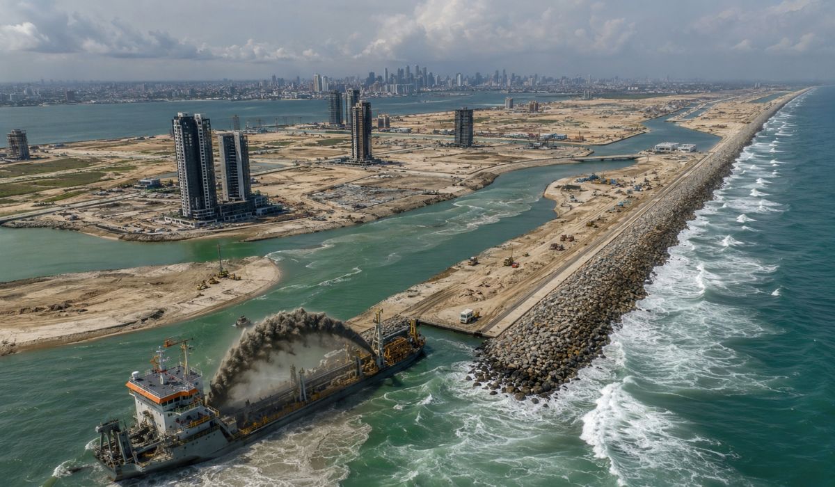
Nigeria Dumps 120 Million Tons of Sand into Atlantic to Build Massive City with 8.4 km Sea Wall for Protection Against Ocean Waves and Erosion


The alert for heavy rain is not limited to the volume itself. Storms associated with extratropical cyclones frequently produce wind gusts, localized hail, and rapid water accumulation in urban areas, conditions that increase the risk of flooding, falling trees, and power outages. For residents of the South who planned outdoor activities this last weekend of April, the recommendation is to follow civil defense warnings and avoid unnecessary travel during periods of more intense rain.
How temperatures will plummet after the rain and cyclone pass
The thermal drop accompanying the extratropical cyclone is the second component of the drastic weather change. On Sunday (26), temperatures already recede from the early hours of the day, and in the mountainous regions of Santa Catarina, thermometers can approach 0°C, a mark usually only regularly reached from June onwards. Afternoon highs remain contained in most of SC and Paraná: they should not exceed 25°C, with the exception of the extreme north of Paraná where thermometers still reach 30°C.
In specific regions, the cold will be even more pronounced. South-central Paraná and the northern mountainous region of Santa Catarina record highs between 17°C and 18°C, values that in mid-April evoke consolidated winter conditions. The capitals will also feel the effects of the change caused by the cyclone: Florianópolis is expected to fluctuate between a minimum of 20°C and a maximum of 23°C, while Curitiba records 18°C for the minimum and 25°C for the maximum, a noticeable drop compared to previous days when the rain had not yet arrived.
What the extratropical cyclone has to do with simultaneous rain and cold
Extratropical cyclones form when a low-pressure atmospheric system associates with a cold front advancing towards the continent. The combination of warm, moist air coming from the north and the cold air mass pushing the front creates intense atmospheric instability, generating the heavy rain that characterizes these systems and subsequently drawing in polar air that drops temperatures after the precipitation passes. This is why the rain on Saturday and Sunday will be followed by intense cold in the subsequent days, a pattern that marks the transition between autumn and winter in Southern Brazil.
The formation off the coast of Rio Grande do Sul positions the cyclone to directly affect Santa Catarina and Paraná. Its proximity to the Rio Grande do Sul coast allows the system to channel oceanic moisture inland to the two states, increasing rainfall in areas further from the coast and maintaining instability for longer than a conventional cold front would. For those who thought April would end without climatic surprises, this weekend’s extratropical cyclone serves as a reminder that autumn in the South is a transition season, and transitions are rarely smooth.
What to expect in the coming days after this weekend’s rain
The trend for the beginning of the week is a gradual stabilization of the weather, but with temperatures remaining below average. The cold air mass following the cyclone will keep nights chilly in the mountains and early mornings uncomfortable even in the capitals, signaling that the winter of 2026 may arrive earlier and with more vigor than usual. For rural producers in Paraná and Santa Catarina, the combination of heavy rain followed by intense cold requires special attention to crops sensitive to early frosts.
The weekend also serves as a warning for the climatic pattern of the coming weeks. If extratropical cyclones already produce heavy rain and temperatures near 0°C in April, May promises even more severe conditions, and early preparation of homes, vehicles, and winter clothing makes a practical difference when the cold arrives before the calendar. Those who thought winter only started in May will discover this weekend that the atmosphere doesn’t follow a schedule.
And you, have you already felt the rain and cold arriving in your city? Do you think the winter of 2026 will be harsher? Leave your opinion in the comments.