Portuguese
  Spanish
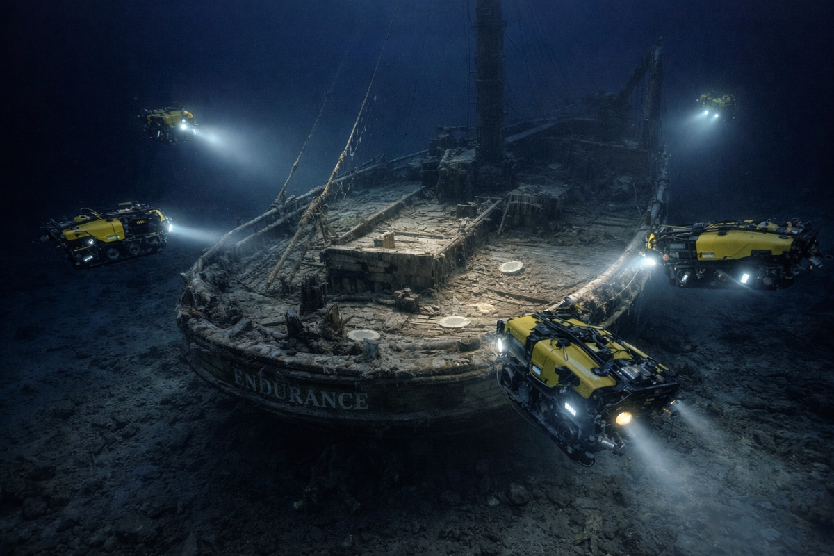
Technology has brought back, in digital form, one of the most famous shipwrecks in the world. The 3D mapping of the Endurance revealed preserved objects on the deck and showed how the sea has kept the ship for 107 years.
The Endurance, the ship from Ernest Shackleton’s expedition, has returned to the spotlight with an underwater mapping that transformed the wreck into a highly detailed 3D reconstruction. The hull is located at 3,008 meters in the Weddell Sea, in Antarctica, and can now be seen almost as if the water had been removed from the site.
Located on March 5, 2022, the ship that sank in 1915 gained new public interest by becoming a digital model and also an exhibit piece in 2026, without a single part being removed from the seabed.
The story draws attention because the wreck remains protected by the Antarctic Treaty and a strict conservation plan. Instead of disturbing the site, technology has begun to return to the human eye one of the most famous ships of polar exploration.
-
How to Prevent Brown Recluse Spider Bites: Common Hiding Spots and Free Tips to Reduce Risks

-
Natto: The Unusual Japanese Superfood Gaining Popularity on Social Media and Driving Record Exports
-
Brazilian Mayor Goes Undercover as Homeless for 24 Hours to Assess Public Services

-
15-Year-Old Entrepreneur Malu Lira Publishes 20 Children’s Books on Financial Education, Earns $500,000, and Expands Her Project to the Amazon Rainforest


The hull appeared whole on the seabed of Weddell
What impresses the most is the state of preservation. Even with fallen masts and structural damage, the hull remains well preserved, with the ship’s name still visible and parts of the deck clearly recognizable more than a century after the sinking.
The extreme cold and the absence of wood-consuming organisms in that area helped maintain the Endurance in rare conditions for a wreck of this age and depth. This has turned the site into a true time capsule of the heroic age of Antarctic exploration.

Plates, boot, and gun continue to be scattered on the deck
The 3D images show plates, a leather boot, and even a signal gun among the objects left when the crew abandoned the ship. The items appear scattered on the deck and in the debris field around the vessel, impressively preserved by the cold environment.
The signal gun has symbolic weight because it is linked to the farewell given to the ship before it disappeared. The isolated boot is associated in analyses with Frank Wild, Shackleton’s right-hand man, although this identification is treated as a hypothesis.
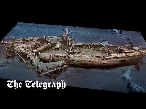
Over 25 thousand images assembled a precise digital twin

According to the Falklands Maritime Heritage Trust, the organization that led the search for the wreck, the mapping gathered over 25 thousand high-resolution images with **laser** and **sonar** data to assemble a scientifically precise digital twin of the site. The result shows the ship from **bow to stern** and also the trail left on the seabed.
Submarine robots scanned from all angles, and the records were joined by photogrammetry, in addition to color corrections that attempt to reveal how the scene would appear under natural light. This process opened up a much deeper reading of the structure, the wood, and the objects scattered around the hull.
Dundee to exhibit in 2026 the replica born from the ocean floor
In **2026**, part of this work gained a new public showcase in **Dundee**, Scotland, with the exhibition of a physical model created from the digital twin. The exhibition brings to the surface a heritage that remains untouched on the seabed and reinforces the worldwide fascination with the history of the **Endurance**.
The model presented in the museum was produced to scale and translates into physical form the data captured by the expedition. The proposal is to allow the public to see up close details that, in the original location, remain hidden under ice, darkness, and extreme depth.
What this mapping changes for underwater archaeology
The case of the **Endurance** shows how underwater archaeology has entered a new phase. Instead of removing artifacts from the ocean floor, the trend now is to record, preserve, and study with extreme precision, reducing risk to fragile and protected historical sites.
In the case of this shipwreck, technology has done more than create impactful images. It has expanded access, deepened research, and transformed one of the greatest symbols of polar exploration into a concrete visual experience for scientists, students, and the general public.
The sea did not return the ship to the surface, but it returned its presence to the world through data, light, and digital reconstruction. This is the point that makes the Endurance circulate strongly again in 2026.
More than 107 years after the sinking, the result is a rare encounter between memory, heritage, and extreme technology. What was trapped on the seabed can now be explored in 3D, with forgotten objects on the deck and a historical scale that continues to impress.