Portuguese
  Spanish
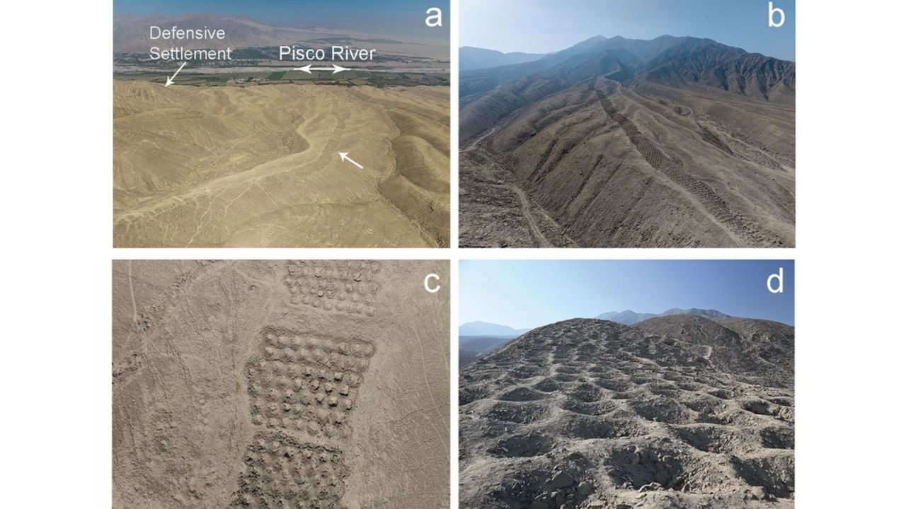
The holes in Peru have once again intrigued archaeologists after a new study by the University of Sydney suggested that the formation of Monte Sierpe, in the Pisco Valley, may have been used as an ancient indigenous market and accounting system. The structure consists of about 5,200 pits aligned over approximately 1.5 km along the edge of the valley.
According to the Refractor, on December 22, 2025, it proposes an economic and social explanation for the site. What once seemed like just a mysterious strip on the mountain may now reveal how products like corn, cotton, and other goods were organized, measured, and traded in the landscape itself.
An archaeological enigma that began from the sky
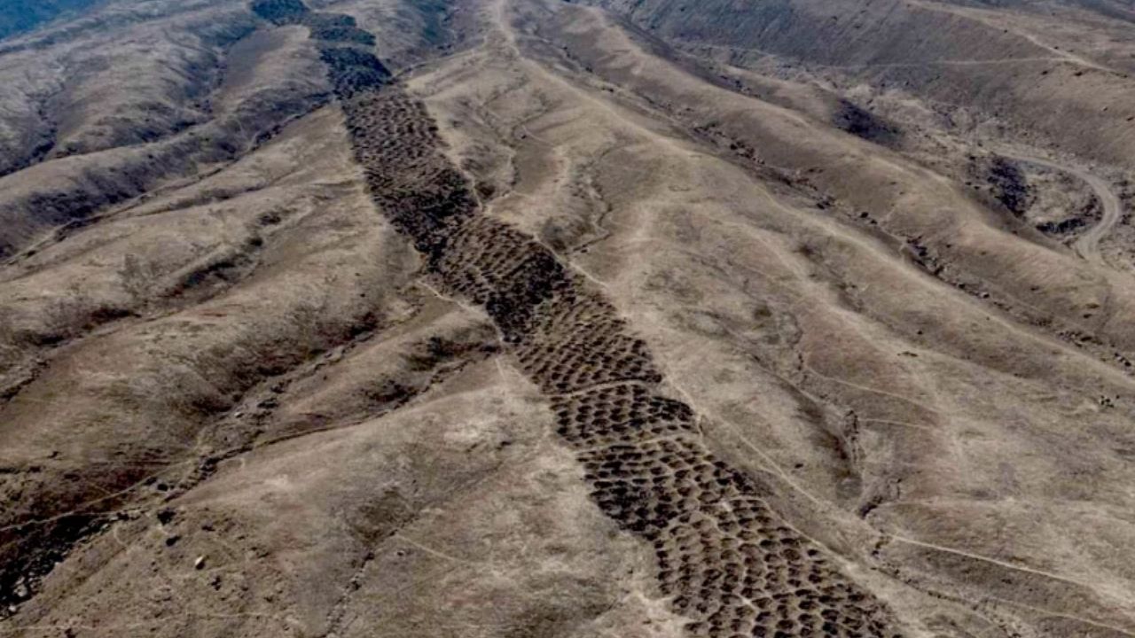
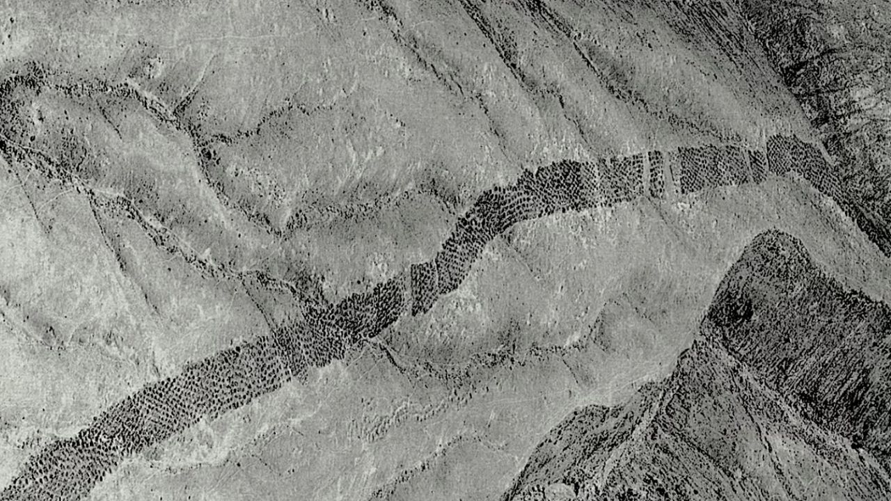
Monte Sierpe, also called the “Band of Holes,” caught international attention in 1933 when aerial images published by National Geographic showed an unusual sequence of open pits in the terrain. Seen from above, the formation resembled a serpent crossing the slope, which is why the name Monte Sierpe became associated with the site.
-
The Little-Known Story of a Home-Built Airplane That Promised Freedom but Faced Safety Issues After Numerous Accidents

-
He Didn’t Build a Plane, But Spent Decades Trying to Make Bicycles Fly with Wings and Pedals; Remaining Models Tell This Unusual Story in Germany
-
Roraima Security Secretary Poses as Doctor to Expose Technician Charging $600 for Free Public Health MRI in Brazil; Technician Confessed

-
To Protect Its Beaches, the Netherlands Deposits 21.5 Million Cubic Meters of Sand into the Ocean, Letting Nature Reinforce Dunes and Shoreline


For decades, the holes in Peru have led to various hypotheses. Some researchers even considered functions related to storage, defense, water collection, agriculture, gardening, or fog harvesting. The problem is that none of these explanations could simultaneously fit the size, pattern, and strategic location of the formation.
What the drones revealed about Monte Sierpe
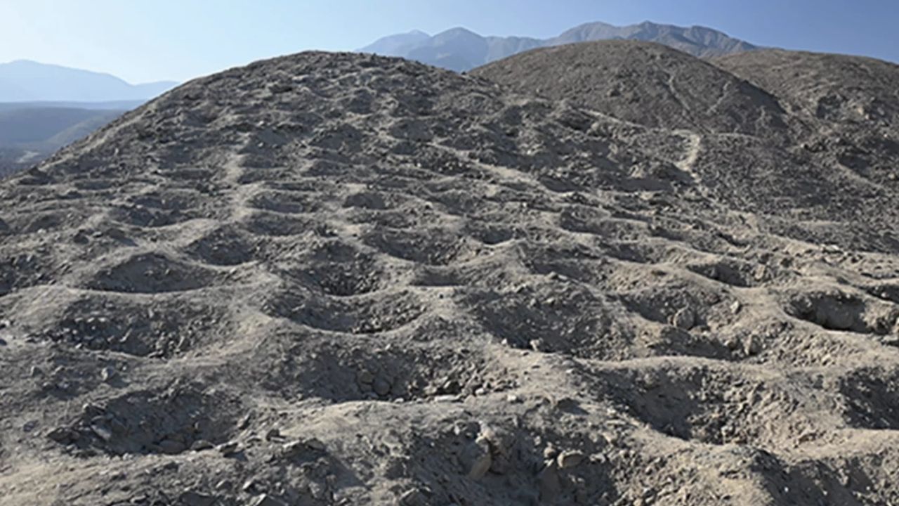
The new stage of the research used drones to map the site more precisely. This survey allowed us to observe that the pits are not randomly scattered. They appear organized in blocks, rows, and sections, separated by empty spaces that seem to allow for the circulation of people.
This organization caught attention because some parts repeat numerical patterns. In others, there is an alternation between specific quantities of holes. For the researchers, this repetition suggests that Monte Sierpe may have functioned as a kind of visual counting system, much closer to a social infrastructure than a simple geological curiosity.
Holes in Peru may have functioned as large-scale accounting
The strongest hypothesis of the study is that the holes in Peru served to make quantities visible. In a society without modern currency, products could be placed in pits, grouped by type, origin, or exchange value, allowing merchants and communities to quickly assess stocks.
This idea brings Monte Sierpe closer to quipus, Andean instruments made with cords and knots used to record information. The difference is that, in this case, the possible accounting system would be drawn on the ground. Instead of a spreadsheet, an entire strip of the mountain could have helped organize exchanges, tributes, or goods.
Corn, cotton, and plants outside the local environment
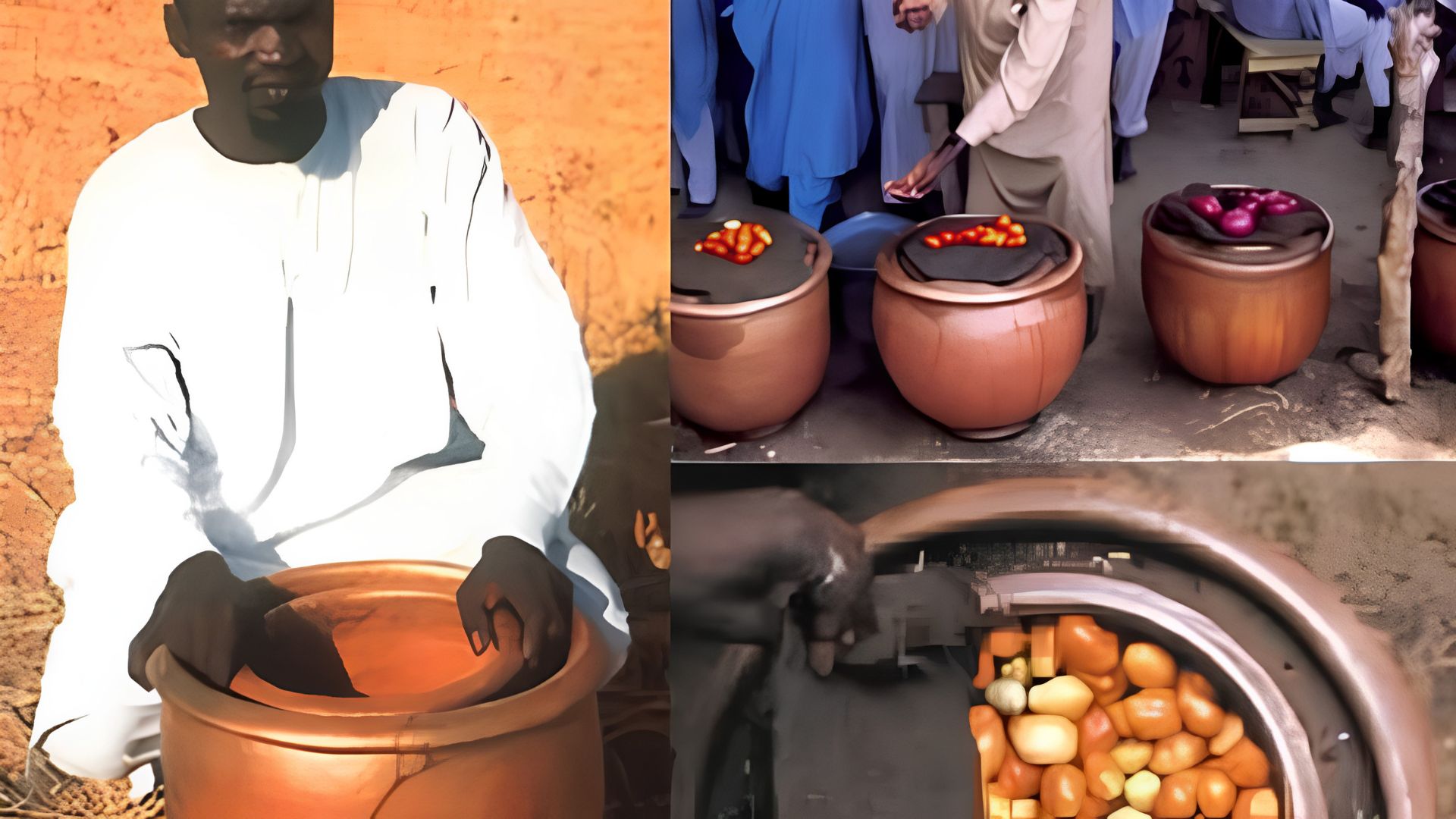
One of the most important points of the research came from the analysis of sediments taken from the pits. Scientists found microbotanical traces of corn, cotton, squash, amaranth, pepper, and other plants. Indications of reeds, traditionally used in basket making, were also identified.
This detail weighs in the interpretation because many of these plants are not typical of the arid area where Monte Sierpe is located. Moreover, some of them do not spread pollen easily by wind. This reinforces the possibility that products were brought to the site by people and deposited in the pits during commercial or administrative meetings.
An indigenous market before the Incas?
Researchers are considering the possibility that Mount Sierpe was used as an indigenous market or trading center before the Inca consolidation in the region. The site is located in a strategic area, close to routes that connected different ecological areas and pre-Hispanic paths.
This position would have favored meetings between farmers, fishermen, llama caravans, and itinerant traders. If the hypothesis is correct, the holes in Peru were not just marks on the ground, but part of a social technology created to bring people together, organize goods, and facilitate negotiations.
The role of the Chincha in the region’s economy
Dating and archaeological context indicate significant use during the Late Intermediate Period, when the Chincha Kingdom had a strong presence in the Pisco Valley. Historical records describe the Chincha as important traders, with networks extending along the coast and inland.
This makes the market hypothesis even more plausible. A society with intense product circulation needed efficient ways to measure, compare, and record goods. Mount Sierpe may have served precisely as an interface between landscape, commerce, and administration, before eventually being adapted to the Inca system.
Why the function is not yet fully determined
Despite the evidence, the researchers themselves avoid treating the case as a definitive answer. The exact function of Mount Sierpe is still a subject of investigation, and the study presents a hypothesis strengthened by drones, mathematical patterns, and plant residues, not an absolute conclusion.
This caution is important because complex archaeological sites rarely have a single explanation. The holes in Peru may have had different uses over time, transitioning from a local exchange space to an instrument of recording, counting, or control in another political context. The landscape may have changed function as the societies that used it changed.
What Makes Monte Sierpe So Rare
The mystery also remains because a formation of this type does not appear replicated with the same clarity throughout the Andes Mountain Range. If it was so useful, why didn’t something similar become common in other regions? This question remains open.
One possibility is that Monte Sierpe responded to a very specific combination of geography, trade, population, and regional power. Another is that similar structures may have existed but were not preserved or identified. The fact is that the alignment of 5,200 pits over 1.5 km remains one of the most intriguing examples of human modification of the Andean landscape.
An Ancient System Without Currency, But With Its Own Logic
The most fascinating part of the research is showing that ancient societies could create complex accounting systems without relying on alphabetic writing, metallic currency, or paper. The organization could be in ropes, knots, paths, objects, baskets, and even holes dug in the ground.
In this sense, Monte Sierpe changes the question. Instead of asking only “what were these holes for?”, the study suggests another question: how did indigenous peoples transform the landscape into a tool for economic organization? This shift makes the site more than a visual mystery: it becomes a clue about ancestral administrative intelligence.
The Mountain May Have Been an Ancestral Spreadsheet
The holes in Peru show how a seemingly silent place can hold information about trade, counting, and social coexistence. Monte Sierpe intrigued scientists for almost a century because it seemed too large to be accidental and too strange to be explained by a simple function.
Now, with drones, soil analysis, and comparison with Andean accounting practices, the hypothesis of an ancient indigenous market gains strength. It is not yet a definitive answer, but it is the most human explanation so far: people using the mountain itself to organize products, meetings, and numbers. Do you think it is more likely that Monte Sierpe was a market, an accounting system, or is there still another hidden function in these 5,200 holes? Leave your opinion in the comments.