
 Portuguese
  Spanish
The rotation is so slow that it advances less than a nail grows, and the most curious thing is that it reversed the direction of the region’s past geological history. Researchers combined decades of earthquakes with satellite positions to reach this conclusion, which helps map faults capable of generating tremors in southern Iberia.
Spain and Portugal are on land that rotates slowly clockwise, in a movement of only a few millimeters per year caused by the collision between the African and Eurasian tectonic plates. The conclusion is from a study published in the scientific journal Gondwana Research, in January 2026, which mapped with unprecedented precision the tectonic stresses of the Western Mediterranean, in the region where the two large plates meet, south of the Iberian Peninsula.
The research was led by geologist Asier Madarieta-Txurruka, from the University of Granada and the University of the Basque Country, in Spain, and combined two types of data to reconstruct how the Earth’s crust is deforming today. According to the authors, the Eurasian and African plates approach each other by about 4 to 6 millimeters per year, an advance slower than the growth of a nail, and it is this constant and uneven pressure that makes the Iberian Peninsula rotate slowly as a block.
How the study discovered the rotation of the plates

On one hand, they analyzed the focal mechanisms of earthquakes, which reveal how the rock fractured during each tremor and what type of stress acts in depth. On the other, they used GNSS data, satellite positioning systems similar to GPS, capable of measuring tiny displacements on the Earth’s surface, on the millimeter scale.
-
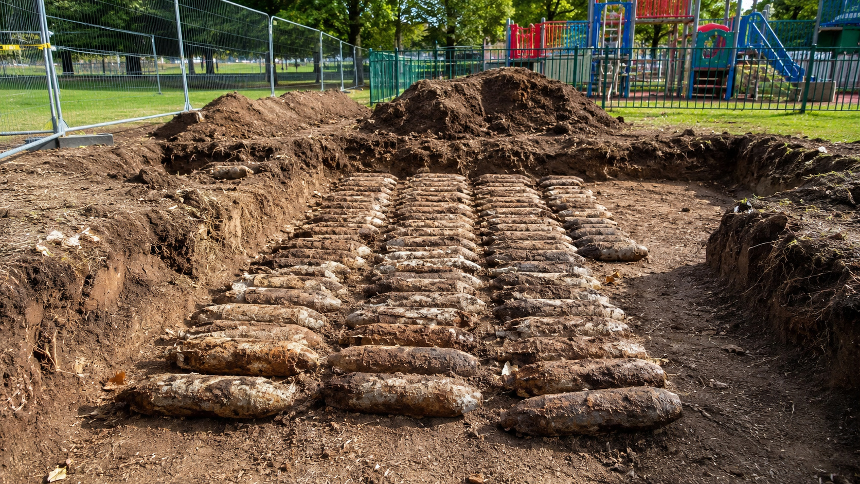
Workers renovating a playground in northern England uncover 176 World War II bombs buried underground; training artifacts still contained explosives.

-
Brazilian Architect Transforms Waste into Sustainable Homes with Solar Power and Rainwater Systems for 40 Years

-
Security Guard Becomes Doctor at Louisiana Hospital Where He Once Worked, Studied Chemistry Between Shifts

-
Woman Rescued from Luxury Complex in Brazil Worked Without Pay for 55 Years, May Be Entitled to Over $300,000


These satellite data came from monitoring networks such as EUREF and the Spanish ERGNSS, as well as partner agencies in Portugal and Morocco. By combining seismic stress fields with deformation rates measured by satellite, the team produced maps of tectonic stresses and surface deformation with a much more detailed resolution than previously available, offering a current portrait of how the plates interact in the region.
Why the Iberian Peninsula rotates clockwise
The rotational movement happens because the convergence between the Eurasian and African plates occurs obliquely in relation to the southwest margin of the Iberian Peninsula. Instead of a frontal and uniform push, the pressure arrives at an angle, and this, combined with the complex geological structure of the region, generates a kind of torque, a twisting force that makes the Iberian block slowly rotate clockwise.
A detail that enriches the discovery is that this clockwise rotation represents a reversal in relation to the geological past of the region, which has already rotated in the opposite direction throughout its long history. It is worth remembering that the Iberian Peninsula functions as a complex tectonic system, where fragments of crust of different ages and characteristics interact. The boundary between the plates, in this area, is not a single clear fault line, but a diffuse zone of distributed stresses.
The four tectonic sectors of the Western Mediterranean
The study divided the region into four main tectonic sectors, each responding differently to the pressure between Africa and Eurasia: the Atlantic, Gibraltar, Alboran, and Algerian-Balearic sectors. In the Atlantic sector, stresses are transmitted more directly between the two plates, with a clearer contact between them.
Further east, part of this energy is absorbed in areas where the Earth’s crust is thinner, especially in the Alboran Sea and along the continental margins of the Gibraltar Arc and the Tell Atlas in North Africa. Researchers also identified tectonic activity in inland regions, far from the main plate boundaries, which show low deformation rates but still record regional compression, including areas traditionally seen as stable, such as the Iberian interior and the Pyrenees.
What this means for earthquake risk
In addition to confirming and quantifying the rotation, the research has a direct practical application in seismic risk assessment. By better understanding how stresses are distributed along this diffuse boundary between the plates, scientists can identify which faults and geological structures have the greatest potential to generate earthquakes, what the possible magnitude of these tremors would be, and how the crust tends to move in the region.
This is especially relevant because the south of the Iberian Peninsula and the north of Africa already have a history of significant earthquakes, and the region of contact between the plates is even pointed out as capable of generating large tsunamis. Building a more complete database of active faults and integrating different sources of information, as this study did, helps improve prediction models and calculate deformation even in little-studied areas, which has concrete value for the protection of populations.
A snapshot of the present, not a closed certainty
Despite the unprecedented precision, the authors themselves make important caveats that deserve to be highlighted, in the name of rigor. The study is described as a small window into geological evolution, that is, an instant snapshot of a process that unfolds over millions of years. What satellites and earthquakes show today is the clearest picture ever obtained, but still limited to a few decades of observation.
The researchers also warn that, in some areas, the stress directions indicated by earthquakes and the deformation measured by satellite do not always perfectly coincide. Therefore, they recommend caution not to overinterpret weak patterns in regions with few monitoring stations. It is, therefore, a high-resolution advance, but with recognized uncertainties, and not a definitive and closed conclusion about the behavior of the plates.
The discovery that the Iberian Peninsula slowly rotates clockwise, pushed by the collision between the African and Eurasian plates, is a fascinating reminder that the ground beneath our feet, even seeming solid and immobile, is always in motion. More than a curiosity, the study offers valuable tools to understand the earthquake risk in the Western Mediterranean, showing how science can capture, millimeter by millimeter, the slow dance of the continents over geological time.
Did you know that entire continents can slowly rotate due to the movement of tectonic plates? What impresses you the most when thinking that the land under Spain and Portugal moves a few millimeters per year? Leave your comment, tell us what you think of this discovery, and share the article with those interested in geology, science, and the mysteries of our planet.


