Portuguese
  Spanish
The image of rivers is a metaphor: it is not liquid lava, but corridors of hotter and weakened rock that flow in the mantle over millions of years. Even so, the finding is surprising, suggesting that the most stable heart of a continent may be being corroded from within.
A scientific discovery is changing what was known about the Earth’s depths. Hidden hundreds of kilometers deep, what scientists describe as two rivers of molten rock are slowly devouring the ancient base of the North American continent towards the Black Hills, overturning the old certainty that this core was an untouchable and immovable anchor of the planet.
The research was conducted by a team led by geophysicist Xiaotao Yang, a professor at Purdue University in the United States, and published in the scientific journal Nature Communications. First of all, an important caveat is needed: the expression rivers of molten rock is an illustrative image, as it is not liquid lava flowing underground, but corridors of hotter and deformable rock in an extremely slow flow. Next, we explain what was found, how scientists came to this conclusion, and why this changes the way we understand continents.
What are these rivers of molten rock
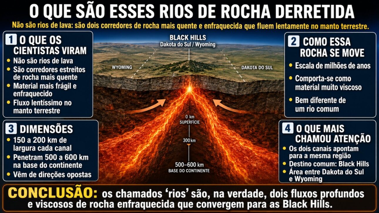
What the researchers identified are not rivers of lava, but two narrow corridors of hotter, fragile, and weakened rock that move in the Earth’s mantle at an extremely slow pace, on the scale of millions of years, behaving more like a very viscous material than like a liquid, quite different from the image of a common river.
-
Project Daedalus: The 190-Meter Spacecraft Aiming to Reach Another Star with Nuclear Fusion and a 50-Year Fuel Supply

-
When Do Brazil and Japan Face Off in the World Cup?

-
Giant 2.2 km Device Sweeps Plastic from Pacific Ocean, Cleaning an Area the Size of a Football Field Every 5 Seconds to Contain World’s Largest Ocean Garbage Patch
-
Brazil’s Public Health System Launches Study on Semaglutide’s Impact on Obesity


Each of these channels is between 150 and 200 kilometers wide and penetrates 500 to 600 kilometers into the base of the continent, coming from opposite directions.
The detail that most caught the scientists’ attention is that both point to the same region, the Black Hills, between South Dakota and Wyoming, as two watercourses that converge at the same point within the territory.
The ancient heart of the continents
To understand the importance of the discovery, it is necessary to know the disturbed structure.
Continents form around a craton, the oldest and most rigid core of the Earth, supported by a thick root of cold, resistant rock that plunges deep into the mantle and acts as an anchor, keeping the continent stable for billions of years, according to the classical model of geology.
It was precisely this stability that seemed unshakeable.
Regions like Kansas, Nebraska, and the Dakotas, in the interior of the United States, are known for their geological calm, in contrast to the Pacific coast, full of volcanoes, faults, and earthquakes.
The novelty brought by the study is that even this supposedly untouched core is being worn away from below, something that contradicts one of the most established ideas about how continents are maintained.
How scientists saw so deep
No one dug hundreds of kilometers to make this discovery.
To see the depths, the team used a technique called seismic noise tomography, which takes advantage of the Earth’s constant hum, the vibrations generated by ocean waves and the climate, captured by thousands of sensors spread across the surface, to create a kind of three-dimensional image of the planet’s interior.
The principle is similar to that of a medical imaging exam, but applied to the Earth.
Seismic waves travel quickly through cold, rigid rocks and more slowly through warmer, more fragile regions.
By mapping these speed differences, researchers were able to distinguish solid zones from weakened zones, revealing the corridors that penetrate the craton and had never been mapped before.
A new explanation for continental erosion
The discovery also changes the theory about what causes this erosion.
Until now, the main explanation attributed the erosion to water released by an ancient oceanic plate that sank beneath the western states, which would have softened and weakened the edge of the craton, but the new model shows that the wear extends across the entire western margin, and not just at a specific point.
According to the study, this weakening accompanies the movement of the mantle, and not just the trajectory of the ancient plate that sank.
This difference is important because, if the mantle’s own flow can erode the base of a continent, the same process could be happening in other ancient cores around the world.
Rare volcanic rocks from the region, such as kimberlites, which bring fragments from the depths to the surface, reinforce the idea of a long and irregular erosion over geological time.
What this means for the future
Despite the dramatic tone, there is no reason for immediate alarm.
This is a process that occurs on the scale of millions to billions of years, with no imminent risk to people, and what is at stake is the scientific understanding of how continents are born, transform, and can lose part of their structure over immense geological periods, and not a threat to future generations.
Scientists raise the possibility that, in a distant geological future, pieces of the base of this root could detach and sink into the hotter mantle, thinning the continent in stages.
This type of knowledge has practical value, as many deposits of valuable minerals form on the edges of cratons, and mapping how these edges erode helps both in the search for resources and in reading the long history of the planet.
The study, in the end, shows that not even the most stable heart of a continent is as permanent as once imagined.
The discovery of the so-called rivers of molten rock beneath North America is one of those findings that rewrite what we have learned about the planet, revealing that the oldest and most stable core of a continent may be slowly eroded by deep flows in the mantle.
More than a threat, it is a fascinating window into the invisible processes that shape the Earth over billions of years.
Understanding these mechanisms helps science piece together the puzzle of how continents emerge, change, and, one day, may transform into something very different from what we know.
And you, did you ever imagine that the seemingly solid interior of a continent could be transforming in the depths? What did you think of this discovery about the Earth’s innards? Leave your comment, share your opinion, and help spread the article to those interested in geology, science, and the mysteries of our planet.