
 Portuguese
  Spanish
In the Castelo region, 100 km from Corumbá via the Paraguay River, the improvised 8 km road was opened after the natural channel was blocked by aquatic vegetation. According to Campo Grande News, Civil Defense and Dnit assessed the situation, with disagreement over conditions for clearing during the reported period locally.
The improvised 8 km road opened in the Castelo region, in the southern Mato Grosso Pantanal, emerged as an emergency logistical route after the natural access channel to Baía do Castelo, via the Paraguay River, was blocked. The situation was reported by Campo Grande News on March 2, 2026.
The channel, used as a waterway connection to the region, was blocked by the concentration of baceiro, a formation of dense and floating aquatic vegetation. With navigation compromised, residents opened a land path to the riverbank, creating a temporary alternative for access, circulation, and support for local activities.
Channel blockage affected the main waterway access route
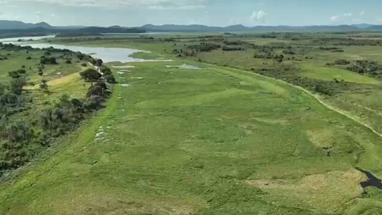
The natural channel connecting the Paraguay River to Baía do Castelo was closed by the concentration of aquatic vegetation. According to the report, the blockage had occurred about a month before the publication, interfering with the movement of residents and the functioning of economic activities linked to the region.
-
Over 60,000 People Displaced in Brazil’s Maceió After Sinkholes Expose 35 Underground Salt Mines Linked to Braskem Disaster

-
Brazil Sets Record with 9.3 Million Foreign Tourists in 2025, a 37% Increase

-
Brazil’s Grupo Boticário Earned $7.5 Billion in 2025, Now World’s Largest Beauty Retail Network

-
Scientists Warn Extraterrestrial Life May Have Left Clues on Other Planets, But Humans Might Be Missing Them in Space Missions


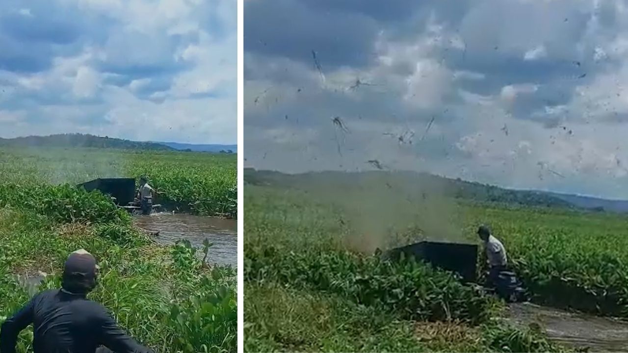
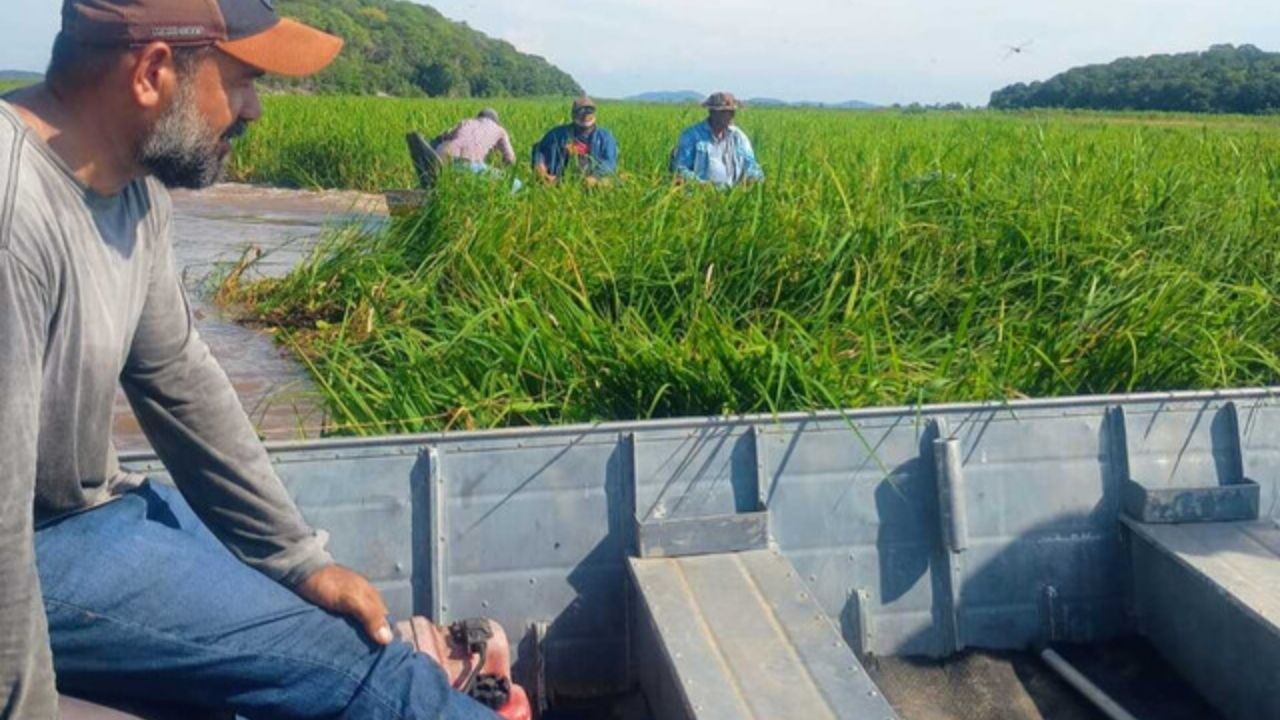
The baceiro is formed by grasses, water hyacinths, water lettuce, and roots. In areas of the Pantanal and influenced by the Paraguay River, this material can cluster into dense floating masses, creating obstacles to navigation in narrow channels or sections with lower flow.
From an infrastructure perspective, the central problem was the interruption of a natural transportation route. In Pantanal regions, rivers and channels function as access corridors, especially where road circulation is limited, seasonal, or dependent on environmental conditions.
The Castle Bay is mentioned in the report as an area of hills, striking landscape, and a passage for embarked tourists. The blockage of the channel, therefore, affected both local mobility and the operation of activities related to livestock, sport fishing tourism, and riverside life.
Improvised road became an 8 km land alternative
Faced with the obstruction of the channel, residents of the Castle opened an improvised road of 8 km to the riverbank. The route was created as an emergency measure to restore some land access while the waterway remained blocked.
The region is about 100 km from Corumbá via the Paraguay River, southwest of the municipality. This distance makes water access especially relevant for circulation, transportation of supplies, movement of people, and support to local properties.
The improvised road should be understood as a provisional logistical solution, not as a definitive replacement of the channel. It meets an immediate need for circulation but does not resolve the blockage of the natural water route.
The case also highlights the need for planning alternative routes in areas subject to environmental changes. In the Pantanal, access infrastructure needs to consider periods of flooding, drought, floating vegetation, navigability, and maintenance of land paths.
Civil Defense conducted a survey and Dnit pointed out technical limitations
The municipality’s Civil Defense conducted a survey of the situation in mid-February and passed the information to Dnit, the National Department of Transport Infrastructure. The federal agency evaluated the possibility of clearing the channel but pointed out limitations at that time.
According to the report, Dnit informed that the removal of vegetation would require higher waters. The agency also indicated the risk of the equipment not being able to move the undergrowth and even suffering damage during the operation.
The technical evaluation involved water level, type of equipment, and capacity to move the accumulated vegetation. The structure mentioned was a tugboat with a kind of “fork” at the front, used to try to open a passage in the floating material.
Dnit stated, based on videos received by the technical area, that the water level at the site would be below waistline. This assessment was one of the factors used to justify the infeasibility of the operation at that time.
Discrepancy over depth altered the operation’s assessment
Residents of the region contested the assessment of the water level. Rancher Ozéias Araujo, who manages Fazenda Nova Jerusalém with his family, told Campo Grande News that the measurement considered by the agency was made in another section, not in the channel bed.
According to Araujo, although the Paraguay River was low, the channel would be deep enough for large vessels to pass, reaching five meters in the bed. The discrepancy shows how measurements at different points can change the reading on the feasibility of an unblocking operation.
This point is relevant because infrastructure decisions depend on an accurate diagnosis of the affected section. In natural channels, small variations in depth, current, and vegetation concentration can alter the risk and cost of intervention.
The report also states that the channel blockage occurs almost every year, but in that episode, the concentration of vegetation was higher and the river was holding back the current. This indicates a recurring problem, but with varying intensity depending on environmental conditions.
Blockage imposed a challenge for maintaining navigability
The obstructed section involves about 1,200 meters up to the large Baía do Castelo. The length helps explain why the removal of the blockage would not be simple, especially with dense vegetation and the need for appropriate equipment.
Ozéias Araujo reported that residents tried to open a passage with a small boat, but the concentration of vegetation made the attempt unfeasible. One of the alternatives mentioned was to use a freighter, a larger vessel used for freight, to manually remove part of the accumulated material.
Maintaining navigability in the Pantanal involves different challenges than those found on conventional roads. The obstacle is not just physical; it changes according to water, wind, current, vegetation, and river level.
Therefore, the improvised 8 km road appears as an access response, while the unblocking of the channel remains a matter of managing the river route. There are two distinct fronts: one terrestrial and emergency, the other hydrographic and dependent on technical conditions.
Ranching and fishing tourism depend on predictable access
The report cites livestock as the predominant activity in the Castelo region. In remote areas of the Pantanal, regular access is important for supply, worker transportation, property management, and communication with other locations.
Sport fishing tourism was also affected, as it depends on navigable routes, safe transportation, and predictability for the arrival of boats. When a natural channel is blocked, the activity loses efficiency and may have to reschedule trips.
Access infrastructure in the Pantanal supports economic chains that depend on both water and land. When navigation fails, emergency land routes can reduce impacts but do not fully replace the function of the channels.
For riverside residents, the interruption of the channel also alters the operational routine of transportation. The issue is not limited to tourist or productive transport; it involves daily circulation in a territory where the river is part of the basic infrastructure.
Case reinforces the need for plans for alternative routes
The blockage of the Baía do Castelo channel shows how infrastructure in the Pantanal needs to deal with recurring natural phenomena. Aquatic vegetation, variable water levels, and narrow channels can compromise circulation at different times of the year.
A more structured response could include periodic monitoring of critical channels, pre-definition of alternative routes, communication protocols between the community, Civil Defense, and federal agencies, as well as clear technical criteria for evaluating clearing.
The improvised road solved an immediate access need, but the episode points to a greater demand for territorial planning. In Pantanal areas, infrastructure needs to be flexible because paths may change according to water and vegetation behavior.
The case of the Castelo region, near Corumbá, shows that logistics in the Pantanal do not depend solely on opening roads or maintaining navigable rivers. It depends on integrating both forms of circulation, with technical response, local diagnosis, and planning for blockage periods.
Do you think that regions of the Pantanal should have permanent plans for alternative routes when natural channels are blocked by vegetation? Leave your opinion in the comments and tell us if the priority should be quick clearing of the channels, emergency roads, or preventive monitoring of the routes.


