Portuguese
  Spanish
The passage of an instability system keeps municipalities in Rio Grande do Sul under attention this Sunday, with forecasts of strong winds, heavy rain, and changes in weather conditions in part of the South Region.
The National Institute of Meteorology issued a potential danger warning for gales in 24 municipalities of Rio Grande do Sul, with a forecast of winds up to 60 km/h this Sunday (26).
The area included in the communiqué is in the Southeast and Southwest of Rio Grande do Sul, in a scenario of instability associated with the formation of an extratropical cyclone and the advance of a cold front.
The warning starts at 00h01 and continues until 23h59 on the same day, according to Inmet.
-
South Korea to Sink 20 Massive Concrete Coffers Off Busan Coast to Build 1.4 km Breakwater at Jinhae New Port, Part of $9.4 Billion Expansion to Rank Among World’s Top 3 Ports

-
Venice Deploys 78 Massive Steel Gates to Shield City from Extreme Adriatic Tides

-
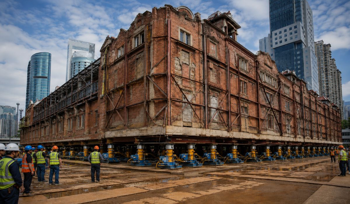
China Uses 432 Robots to Move a 7,500-Ton Historic Building in Shanghai, Preserving Architecture While Creating Space for Underground Center
-
World Cup Ball Chip Uses Technology to Detect Invisible Touches, Confirms Offside, Secures Portugal’s Victory Over Croatia


The potential danger classification indicates the possibility of the meteorological phenomenon occurring within the informed period, which places the municipalities under monitoring during the system’s passage.
The institute’s guidance, in case of wind gusts, is not to shelter under trees, due to the risk of falling and electrical discharges.
Inmet also recommends that vehicles not be parked near transmission towers and advertising signs.
Additional information can be obtained from the Civil Defense and the Fire Department, by calling 199 and 193.
Cities in Rio Grande do Sul under gale warning
The municipalities mentioned in the warning are Aceguá, Alegrete, Arroio Grande, Bagé, Barra do Quaraí, Candiota, Cerrito, Chuí, Dom Pedrito, Herval, Hulha Negra, Jaguarão, Lavras do Sul, Pedras Altas, Pedro Osório, Pinheiro Machado, Piratini, Quaraí, Rio Grande, Rosário do Sul, Santana do Livramento, Santa Vitória do Palmar, São Gabriel, and Uruguaiana.
The localities are in areas of Rio Grande do Sul territory that appear in the communiqué as affected by the risk of gales.
The warning does not mean that all cities will experience the same weather behavior, but it indicates that they are within the range where Inmet forecasts favorable conditions for the occurrence of wind gusts during the validity period.
In the meteorological service, the dissemination of this type of warning serves to guide the population and local agencies about predicted conditions.
As the alerts have a determined deadline, the recommendation is to follow official updates throughout the day, especially in municipalities included in the risk area.

Photo: Reproduction/Inmet/ND Mais
Extratropical cyclone and cold front change weather in the South
According to Meteored, a low-pressure region over Rio Grande do Sul deepened and gradually began to transform into an extratropical cyclone over the Atlantic Ocean.
During this process, the system favors heavy rain over parts of south-central Brazil.
The same forecast indicates the formation of a second, more intense cyclone, off the coast of Argentina over the weekend.
This system is expected to push a cold front towards Brazil between Saturday (25) and Sunday (26), influencing the South Region in the coming days.
Between Friday (24) and Saturday (25), the instability mainly affects Rio Grande do Sul, according to Meteored.
On Sunday (26), the cold front moves north and brings showers to Santa Catarina and Paraná, with the possibility of storms in parts of these states.
The forecast also indicates that, in the following days, the system remains relatively stationary.
As a result, storms may affect parts of Santa Catarina and Paraná, while Rio Grande do Sul tends to experience drier weather after the main phase of instability, according to the meteorological analysis published by Meteored.
Rainfall above 150 mm is also forecast
In addition to the gale warning in Rio Grande do Sul, Meteored’s forecast indicates accumulated rainfall that could exceed 150 mm until Wednesday (29) in the State and, subsequently, in Paraná.
Some forecast rounds cited by the meteorological service indicate volumes of up to 200 mm in certain areas.
The predicted volume is related to the combination of the cyclone, the cold front, and the available atmospheric moisture.
According to Meteored, the systems are expected to cause significant rain in the South Region, with a gradual shift of the instability band from Rio Grande do Sul towards Santa Catarina and Paraná.
Meteored also cites the risk of power outages, falling trees, floods, overflowing rivers, and damage to crops during the weekend and the first days of next week.
These impacts are associated with the forecast of storms and high accumulated rainfall.
As accumulated rainfall can vary from one city to another, the predicted condition should not be interpreted as a uniform volume across the entire Gaúcho territory.
In events of this type, the distribution of rain depends on the movement of unstable areas and the intensity of showers in each region.
Inmet Guidelines for Wind Gusts
In case of strong winds, Inmet advises avoiding shelter under trees and keeping vehicles away from transmission towers and billboards.
The recommendation aims to reduce exposure to falling branches, structures, and electrical discharges during gusts.
Residents of the cities included in the warning should follow Inmet bulletins, Civil Defense announcements, and information from municipal authorities.
Updates are important because meteorological warnings can be terminated, extended, or altered according to the evolution of atmospheric conditions.
In emergency situations, Civil Defense can be reached by phone at 199.
The Fire Department can be reached at 193.
These channels are indicated for occurrences such as falling trees, structural damage, floods, risk to the population, and other situations associated with bad weather.
Gale Warning Valid During Sunday
The gale warning’s validity focuses attention on Sunday (26), between dawn and late evening.
During this period, Inmet forecasts winds of up to 60 km/h in the areas included in the statement, while instability associated with the cyclone and cold front influences the weather in the South of the country.

After the passage of the cold front, the forecast indicates a change in weather conditions in part of the South Region.
Rio Grande do Sul should see a reduction in instability after the most active phase of the system, while Santa Catarina and Paraná may still record storms in the following days, according to Meteored.
Monitoring official alerts remains a guiding measure for residents of the 24 municipalities cited by Inmet.